 Pembina River--The Pembina River flows from the northern part of Turtle Mountain in a rather crooked easterly course through southern Manitoba and the edge of North Dakota about 130 miles, measured in a direct line, to its mouth at Pembina and St. Vincent. From its junction with the outlet of Pelican Lake to Walhalla, at the base of the First Pembina Mountain, its valley varies from 175 to 450 feet in depth. Rock Lake and Swan Lake, on this part of the river, each several miles long and from a half mile to 1 mile wide, are due to deposits brought into this valley by tributaries after it ceased to be the avenue of drainage from the Souris basin. In crossing the Red River Valley the Pembina runs in a channel only 20 to 40 feet deep. Its descent from the northern base of Turtle Mountain to Walhalla is about 700 feet, and thence to its mouth 186 feet, its junction with the Red River being 748 feet above the sea. Long or White Mud River, Clear Water or Cypress River, and Tongue River are its chief tributaries, all from the south side.
WELL AT HUMBOLDT, MINN.
Humboldt is a station of the Great Northern Railway, about 7 miles southeast of St. Vincent, at the farm of Mr. D. H. Valentine, on which this well is situated. It is on the flat plain of the Red River Valley, 6 miles east of the river and 5 miles south of the international boundary. The elevation of the surface is 792 feet above the sea, being a few feet above the highest flood stage of the Red River. On account of the saltness of its water, an analysis of which is given in Chapter X, the well is not used.
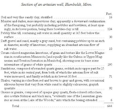
Prof. N. H. Winchell has reported this section,(14) shown by samples from the boring, a summary of which is as follows:

Drift deposits here reach a depth of 180 feet, below which are 458 feet of strata referable to the Trenton, Chazy, and Calciferous series of the Lower Silurian system. Next beneath the drift is a thick formation of magnesian limestone, shown by comparison with the other wells to be the Galena and Trenton strata, classed together as one formation under the second of these names by Whiteaves and Tyrrell, which outcrops at a distance of 75 to 85 miles northward, in the vicinity of Lower Fort Garry and East Selkirk, Manitoba. Its top and bottom at Humboldt, however, are respectively 612 and 317 feet above the sea, the entire formation here being thus beneath the level of Lake Winnipeg. In southeastern Minnesota, southwestern Wisconsin, and adjoining portions of Iowa and Illinois, the Galena and underlying Trenton limestones together range from 200 to 300 feet or more in thickness. The sandstone next below, having a thickness of 71 feet, is evidently the equivalent of the St. Peter sandstone, referable to the Chazy epoch, which in southeastern Minnesota underlies the Trenton limestone, and ranges in thickness there from about 75 feet to 164 feet. Its continuation in Wisconsin, as described by Chamberlin and Irving, averages probably between 80 and 100 feet thick, varying from a maximum of 212 feet down to a fraction of 1 foot. In this and adjoining States, according to Irving, it is continuous "over a region whose diameters are 500 and 400 miles."(15) Beneath this the Humboldt well penetrated 92 feet of shales, partly arenaceous and calcareous, which correspond to the Lower Magnesian or Shakopee limestone of southeastern Minnesota, ranging from 96 feet in thickness at Shakopee to 200 feet in Houston County, while in Wisconsin it is from 65 to 250 feet thick. The reports of the geological surveys of these States regard this formation as of Upper Cambrian age, but Walcott, in his more recent review of the Cambrian,(16) assigns the Lower Magnesian limestone wholly or mainly to the base of the Lower Silurian system. Its eastern equivalent is the Calciferous sandrock of New York. The entire Cambrian and Algonkian systems are wanting in this section, and the Lower Silurian strata rest directly on the Archean crystalline rocks.
From The Glacial Lake Agassiz,by Warren Upham
No comments:
Post a Comment