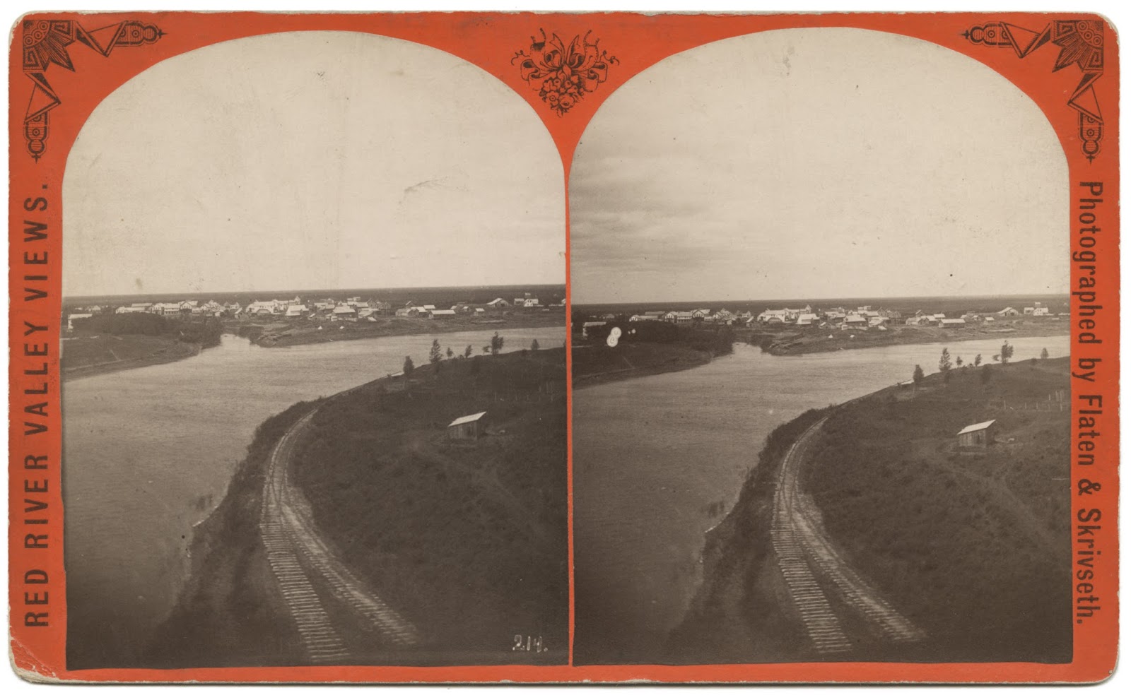
 PHOTO INFO: A stereoview showing the railroad track along the eastern bank of the Red River in St. Vincent. This track is the continuation of the one coming in from the east into town from the "Y". This was laid down early on in anticipation of the main line going through town and over the river, but a rail bridge was never built.
Swan Anderson would get fan mail from people far and wide that had once lived in St. Vincent and the surrounding area, generated from his newspaper columns for the Enterprise, and even from his toll-free phone number into his home. Swan kept sharing history even when he was in the nursing home. And thank goodness he did.
Speaking of fan mail, let me share with you a letter Swan received from the LeMasuriers of Ontario, California; as many reading this may remember, the LeMasurier family lived in St. Vincent at one time. This letter shares some more history about St. Vincent and the railroads. Please note that the story told in the letter is second-hand, being told to the LeMasurier family by George (aka "Shorty") and Bessie Cowan. That does not make it any less true, but I wanted to be sure everyone knows the chain of how the story came to us.
Read on...
Before the turn of the century and when the railroad from Winnipeg east wasn't finished, St. Vincent was a booming railroad town. The round house was out by Lake Stella and had a turntable to turn the engines around. The long depot in St. Vincent housed the Customs and Immigration offices. There was also a Signal House. In 1901 William LeMasurier bought it and moved it to his farm north of St. Vincent. He and his bride, the former Maggie Easter, started housekeeping there in 1902. The land north of St. Vincent and west of the Emerson road was all railroad land. Phillip LeMasurier bought some and later sold it to his sons, William and Arthur. John and George Cowan bought some, also Mose Parenteau and Austin Griffith. The railroad reserved a right-of-way along the top of the river bank. Bessie Cowan told me at one time the railroad had planned to build a bridge across the Red River on Shorty's land.
The Great Northern Hotel was a three-story building with a ballroom on the third floor. Bessie Cowan gave us a picture of it and we left it with the Pembina Museum when we left St. Vincent. When the hotel was torn down, the attached section that was the kitchen was bought by the Russells and made into their home. Later, Harold Easton bought it and finally Milton Gregoire bought it and tore it down, and built what is now known as the Nellie Blair house.
The land that the railroad bridge would have crossed into/from is located on this plat map in the northwest corner of Section 35, labeled George Cowan . . .
There was a strip of land from the Red River to the Emerson road, 137 acres in the Village of St. Vincent on its north side. Austin Griffith bought the 36 acres next to the Emerson road and Charlie LeMasurier bought the rest from Peter Monro. Harris remembers when Charlie had a lot cleared along the river. The man doing the work used oxen. Mrs. Morrow, who lived in St. Vincent, used to pick roots and would give Harris fifty cents to haul a load to town for her.


