The Red River of the North has provided a focal point up and down the Red River Valley.
 The River is the thing that separates St. Vincent from Pembina, and also the thing they share. It brought people to them, took goods away, and flooded.
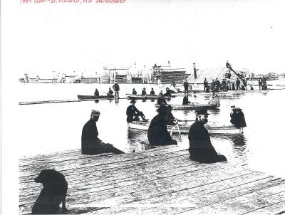
As long as there have been records, and surely even before, the Red River of the North has flooded on a regular basis. A few years may go by without a major flood, but not one year goes by when those living by the river don't watch with apprehension as the snows melt and the spring rains come down, hoping that the waters stay within their banks.
 A recent report suggests that indicators in the natural record (sediment, tree rings, etc.) can help us understand the climatic environment and probable flooding patterns of the Red River's past.
 "...data suggest that [the] climate has been much more variable in the past and that these past climatic changes have substantially increased or decreased the frequency and magnitude of local flooding...research confirms historical accounts that suggest that [the region] was much wetter in the 19th century."
 This photo shows St. Vincent and Pembina from the air during the infamous 1950 flood. My sister Betty was born just as waters started to recede. There's another photo of my mother in a small boat with my sister Sharon, getting helped from it by my Dad, with my Grandpa looking on; they are on main street, looking towards the river, the rest of the town under water...
nice suprise to see this site.
ReplyDeleteThank you from a former Pembina resident