Showing posts sorted by relevance for query stereoview. Sort by date Show all posts

Saturday, December 08, 2007

1882 Emerson Stereoview


A stereoview shows the bustling town of Emerson hit with a catastrophic flood, taken on April 25, 1882. Floods like this was one factor that caused Emerson's boom to bust around this time...

Source: Archives of Manitoba, Emerson 63, N16080.

Thursday, September 05, 2013

"Hell on Wheels" - St. Vincent Style

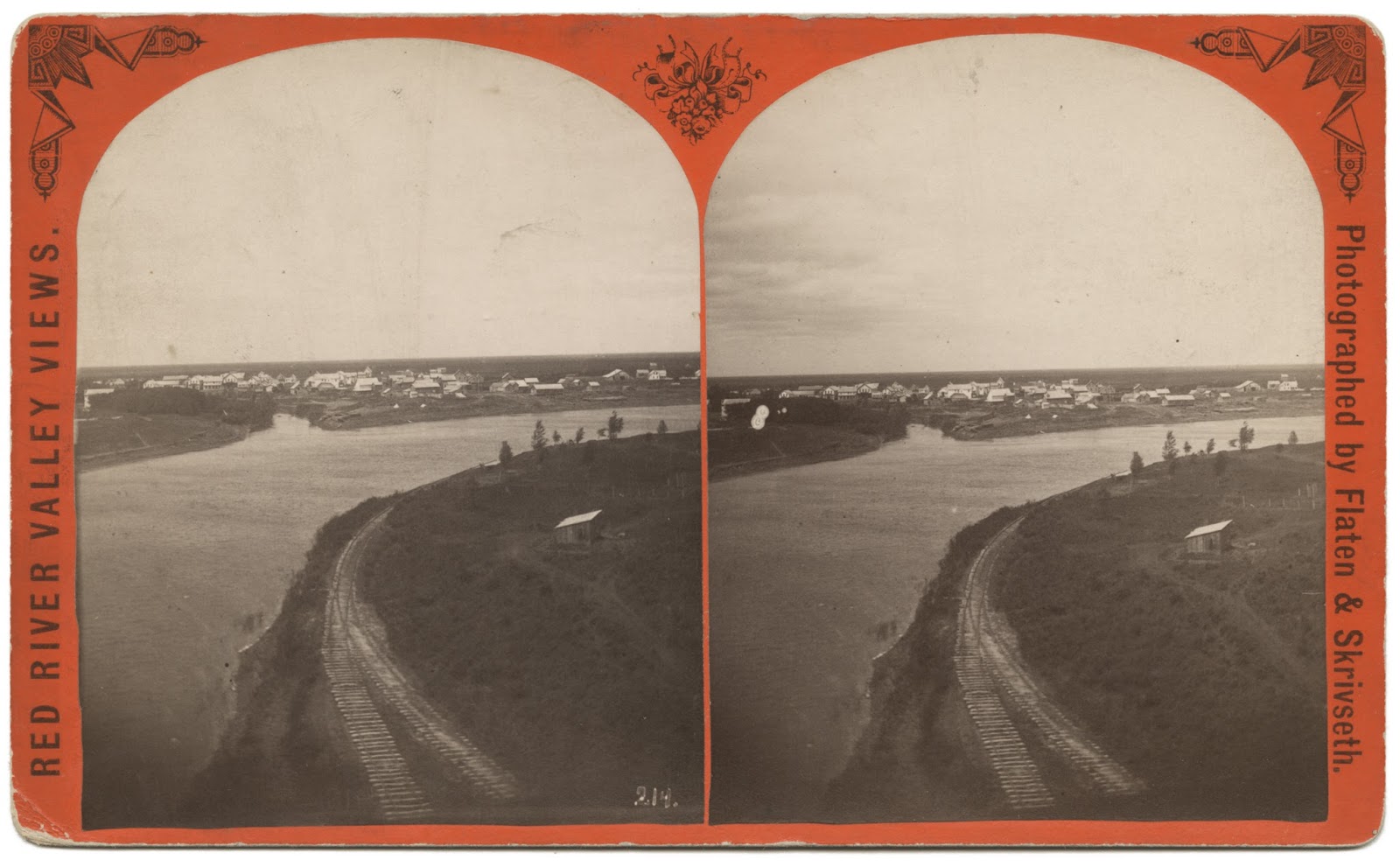
The early spur track into St. Vincent went down to the river,
then followed it some ways north.  In this stereoview, you
can see Pembina in the background looking west, and the
Pembina River tributary  (Date Unknown)1
[Click to Enlarge...]


Three things defined St. Vincent from its beginning:  The river that ran by it, the land that surrounded it, and later, the railroad that was built through (and by) it.

I wanted to share the story of how the railroad came to St. Vincent.  No one that lived during that time is left to share that story with us, so we must go to the records of history and pull the story out, to shed light on it, to let it tell us why it happened, how it affected us, and what the legacy of it once being here is.

Please, dear Reader, read on!  This is just the tip of a much larger iceberg, a tiny paragraph of a much larger story of how the iron horse not only changed St. Vincent, but our entire country!


...to be technically known as the St. Vincent Extension of the St. Paul & Pacific Railroad, from St. Cloud, 375 miles, to Pembina, near the northwestern corner of Minnesota, and on the border of the British Province of Manitoba. This is to be completed before the close of 1872. It will drain the richest portion of the Red River valley and open direct communication with the British settlements of Winnipeg and the productive valley of the Saskatchewan. It will also serve as the southeastern arm of the Northern Pacific road, reaching to St. Paul and Minneapolis.
Source: Scientific American, Volume XXVI, Number 13, New York, 23 March 1872
Just as construction crews completed the line to St. Vincent, and the Associates eliminated the NPR as a competitor for the CPR contract, the Canadian government slapped up a tariff wall that virtually halted business between St. Paul and Winnipeg.
Source: Boosters Hustlers and Speculators: Entreprenurial Culture and the Rise of Minneapolis and St Paul, 1849-1883, by Jocelyn Wills
In 1857, the Minnesota and Pacific Railway Company was formed with the goal of constructing a mainline from Stillwater to Breckenridge...and a branch line to St. Vincent near the mouth of the Pembina River

After the mainline was completed, the Northern Pacific began construction on the St. Paul and Pacific branch line to St. Vincent, but 1872 witnessed a sluggish market for securities.  This decline was compounded by the Panic of 1873, and the NP was forced to relinquish control of the St. Paul and Pacific.  It went into receivership in August 1873 to a Jesse P. Farley.2

NOTE:  During this time, there was much economic instability in the country, and deep concerns by investors, resulting in the Minnesota legislature enforcing conditions of repayment and investor lawsuits.  This resulted in the Associates stepping in...

The Associates2 raised finances, rights to routes, and secured Dutch bonds, thus making it possible to lease the St. Vincent Extension from Farley [in September 1876], and the contract for completing the line to the Red River and Manitoba.  The St. Vincent Extension [into St. Vincent itself] wasn't constructed until 1878, and was required to be finished by the end of that year.  December 2, 1878 saw the final spike driven in the Extension, and four days later first train of the St. Paul & Pacific travel from St. Paul to Winnipeg via the St. Vincent Extension.
Source: Railroad Development in Minnesota, 1862-1956
The first Minnesota railways going east to west, south to north...
[Click to Enlarge]
To expedite construction, Hill had John S. Kennedy try to convince Farley to lease the St. Vincent Extension to the Red River & Manitoba Railway and to grant Hill and Kittson the contract for laying rails on the unfinished portions of that line.  "The lease would give the Associates control of all operations on the Extension, free them to run it in such way as to facilitate construction, and enable them to channel earnings into the corporation they managed."

But, Farley initially resisted.  The Associates worried because they perceived Farley as being slow in getting the work done.  "Alert to the possibility of losing the land grant, Hill traveled often to the end-of-the-track with Farley, whom he regarded as dilatory and inefficient.  Under stern pressure from the Associates, Farley finally agreed to let Hill and Kittson take over responsibility for construction of the St. Vincent Extension in September 1878."

Yet, rather than being controlled, the work seemed to do the controlling.  Suppliers lagged in delivering materials; October floods covered land and track; construction trains were delayed when locomotives were deprived of water because balky windmills failed; workmen drifted off the job; and snow, with extreme cold, came early.

Construction crews of the St. Paul, Minneapolis and Manitoba
(predecessor of the Great Northern Railway), moving up to the
rail-head; accompanied by soldiers who are on the lookout for
hostile Indians. The 3-story cars were dormitories for men.

[Source:  NDSU Institute for Regional Studies]


Despite frustrating delays, the First Division met the legislative deadlines in 1878.  The nearly 105 miles added in one year was more new track than had been laid by the St. Paul & Pacific companies for some seasons...Soon track-laying was completed from Warren to St. Vincent...and on November 10, 1878, the first train from St. Vincent pulled in to St. Paul.
Source:  The Great Northern Railway: A History
The line from St. Vincent to the St. Vincent Junction was removed in 1952. Railway Service to St. Vincent was over...
_______________

1 - The photograph that was used to create this stereoview was taken by Jacob Skrivseth. In the fall of 1879, Skrivseth became a partner of O. E. Flaten in Moorhead, Minnesota. The two men built a traveling wagon with a built-in darkroom. Flaten stayed in Moorhead, and Skrivseth traveled throughout the Red River Valley shooting town and farm scenes. Flaten & Skrivseth also were the official photographers for the St. Paul, Minneapolis, & Manitoba Railroad (which later became the Great Northern Railway...)

2 - Jesse Farley had two decades of experience in railroading, but he also had liabilities...He had next to no political influence in Minnesota,...he was nervous, jealous, and often tactless.  Farley nevertheless worked hard to carry out an almost impossible task.  The northern 104 miles of the St. Vincent Extension were a great worry.  Earlier, the First Division had laid track from south of Glyndon, where it crossed the NP, to north of Crookston, ending there in "...an uninhabited prairie with no human habitation in sight." [Source:  The Great Northern Railway, by Muriel E. Hidy]

3 - The Associates were Donald Smith (Hudson Bay Company), James J. Hill, John S. Kennedy, Norman Kittson, and George Stephen (Bank of Montreal), formed in 1877. They made sure the Dutch investors got paid, the St. Paul & Pacific got good management, and remained solvent.  Later, the CPR Syndicate was formed in 1881 by Hill with Stephen, Smith, and Richard Angus; their original investment of $100,000 yielded an eventual 17 million dollars after 4 years.

Sunday, June 23, 2013

What Could Have Been

From the 1893 Plat Atlas - Click to Enlarge
[Map Credit:  Library of Congress]

In the section of Pembina shown above - part of the 1893 Plat Map of Pembina County - you can see how the railroad was set up to come in north/south, but had a spur going southeast towards St. Vincent. In a stereoview of St. Vincent, it shows a spur coming up from the main track into town from the east, that then turn north and goes along the river to the exact point across the Red from the Pembina spur. At that time, the only thing needed was a railway bridge over the river, but that never happened, and that was one reason of many that discouraged more growth in St. Vincent. There was some serious missed opportunities, poorly thought-out politicking, etc. that went into it all. The nail in the coffin came around the infamous 1897 flood, after which J.J. Hill wanted to move the town out to the wye, aka the Junction and higher ground.  But Mayor Deacon said no to the offer, without discussing it with any other city council member, let alone the townspeople.  We can only speculate as to his reasons.

St. Vincent Spur that once went round north to opposite bank
from Pembina's spur, meant to cross river via bridge never
built, every likely thanks to William Deacon's fateful decision


Sunday, June 09, 2019

"...reserved a right-of-way along the top of the river bank"

PHOTO INFO: A stereoview showing the railroad track along the eastern bank of the Red River in St. Vincent.  This track is the continuation of the one coming in from the east into town from the "Y".  This was laid down early on in anticipation of the main line going through town and over the river, but a rail bridge was never built.

Swan Anderson would get fan mail from people far and wide that had once lived in St. Vincent and the surrounding area, generated from his newspaper columns for the Enterprise, and even from his toll-free phone number into his home. Swan kept sharing history even when he was in the nursing home. And thank goodness he did.

Speaking of fan mail, let me share with you a letter Swan received from the LeMasuriers of Ontario, California; as many reading this may remember, the LeMasurier family lived in St. Vincent at one time.  This letter shares some more history about St. Vincent and the railroads. Please note that the story told in the letter is second-hand, being told to the LeMasurier family by George (aka "Shorty") and Bessie Cowan. That does not make it any less true, but I wanted to be sure everyone knows the chain of how the story came to us.

Read on...

Before the turn of the century and when the railroad from Winnipeg east wasn't finished, St. Vincent was a booming railroad town. The round house was out by Lake Stella and had a turntable to turn the engines around. The long depot in St. Vincent housed the Customs and Immigration offices. There was also a Signal House. In 1901 William LeMasurier bought it and moved it to his farm north of St. Vincent. He and his bride, the former Maggie Easter, started housekeeping there in 1902. The land north of St. Vincent and west of the Emerson road was all railroad land. Phillip LeMasurier bought some and later sold it to his sons, William and Arthur. John and George Cowan bought some, also Mose Parenteau and Austin Griffith. The railroad reserved a right-of-way along the top of the river bank. Bessie Cowan told me at one time the railroad had planned to build a bridge across the Red River on Shorty's land.

The land that the railroad bridge would have crossed into/from is located on this plat map in the northwest corner of Section 35, labeled George Cowan . . .
The Great Northern Hotel was a three-story building with a ballroom on the third floor. Bessie Cowan gave us a picture of it and we left it with the Pembina Museum when we left St. Vincent. When the hotel was torn down, the attached section that was the kitchen was bought by the Russells and made into their home. Later, Harold Easton bought it and finally Milton Gregoire bought it and tore it down, and built what is now known as the Nellie Blair house.

There was a strip of land from the Red River to the Emerson road, 137 acres in the Village of St. Vincent on its north side. Austin Griffith bought the 36 acres next to the Emerson road and Charlie LeMasurier bought the rest from Peter Monro. Harris remembers when Charlie had a lot cleared along the river. The man doing the work used oxen. Mrs. Morrow, who lived in St. Vincent, used to pick roots and would give Harris fifty cents to haul a load to town for her.