Thursday, December 29, 2005

Early St. Vincent Area Settlers & Land


This is a land patent, or grant, for a quarter section of land my great grandfather William A. Fitzgerald bought in 1890 near St. Vincent.

Some interesting additional information from the source website, about land records (or "patents") in general from this time period:

Before the homesteaders, soldiers, and other entrymen received their patents, some government paperwork had to be done. Those purchasing land from the United States had to be given receipts for payments, while those obtaining land through military bounty land warrants, preemption entries, or the Homestead Act of 1862, had to file applications, give proof about military service, residence on and improvements to the land, or proof of citizenship. The paperwork generated by those bureaucratic activities, compiled into land entry case files, is held by the National Archives and Records Administration.

The earliest land entry files, those dating from 1788 to the mid-1850's, generally contain little substantive genealogical information. They simply document a financial transaction or provide evidence of military service. Still, for some researchers just knowing that someone purchased land or received a bounty land warrant, that they were at a certain place at a certain time is often more information than they had before viewing the copies of the records.

No two land entry files are alike, nor is the evidence described above guaranteed to be in each case file. Each is an adventure because one never knows in advance what information and documentation it will contain.

Tuesday, December 27, 2005

Context

Part of what I want to do here is learn some of the bigger picture that St. Vincent is part of, meaning how the history of Minnesota evolved in the region beginning with Europeans arriving...

17th Century

1659-1660 - French fur traders Groseilliers and Radisson explore western end of Lake Superior and environs.

1673 - French explorers Marquette and Joliet discover the upper portion of the Mississippi River.

1679 - Frenchman Daniel Greysolon, Sieur du Luth meets with Dakota Indians near Mille Lacs.

1683 - Catholic Missionary Father Louis Hennepin returns to France after exploring Minnesota and being held captive by the Dakota to write the first book about Minnesota, Description de la Louisiane.

18th Century

1745 - The Ojibwe Indians defeat the Dakota Indians at the Kathio, driving the Dakota into southern and western Minnesota.

1763 - Spain receives Louisiana Territory (includes Minnesota west of the Mississippi River) from France in compensation for its loss of Florida during the Seven Years War. Great Britain wins claim to what is now eastern North America (east of the Mississippi River) and Canada.

1770-1804 - Grand Portage (Minnesota) evolves into the western fur-trading headquarters of the British Empire in North America. British troops stationed here act as only military force in Minnesota during the American Revolution. Fur trading continues to be the main source of commerce in Minnesota through the early 19th century.


1775-1783 - American Revolution

1783 - The newly formed republic of the United States of America wins the eastern portion of Minnesota (from the Mississippi river east) from Great Britain in the American Revolution.

1787 - Eastern Minnesota officially designated part of the American Northwest Territories of the United States of America. David Thompson, working for the North West Company (fur-trading) completes the first formal mapping of Minnesota.

19th Century

1800 - France acquires Louisiana Territory from Spain.

1803 - The United States of America purchases Louisiana Territory from France, gaining ownership of the western portion of Minnesota. Boundary disputes with British Canada keep British fur companies in Minnesota until 1818.

1805 - Lieutenant Zebulon Montgomery Pike leads the first United States expedition through the Minnesota country.

1812-1814 - War of 1812 between the United States and Great Britain with their Dakota, Winnebago, and Ojibwe allies.

1815 - Peace treaty negotiated between the Dakota Indian nation and the United States government. First American fur traders enter Minnesota.

1818 - Northern boundary of Minnesota fixed at the forty-ninth parallel. Boundary negotiations with British Canada continue until 1931. Lawrence Taliaferro instated as first United States Indian agent at Fort Snelling.

1819 - Colonel Josiah Snelling begins construction of Fort St. Anthony on land purchased from the Dakota Indians for $2000 US.

1824 - Fort St. Anthony completed. Name changed to Fort Snelling in Honor of Colonel Josiah Snelling's work.

1832 - Henry Schoolcraft credited with finding the source of the Mississippi River at Lake Itasca, Minnesota with his Ojibwe guide Ozawindib.

1836 - Creation of Wisconsin Territory which encompassed Minnesota.

1837 - Land-cession treaties negotiated with the Dakota Indians and the Chippewa Indians for United States rights to a portion of land between the Mississippi and St. Croix rivers. This new land stimulates the lumber industry in Minnesota.

1841 - Chapel of Saint Paul built. Later it would serve to name the state capitol which sprang up around it.

1838-1848 - St. Paul, St. Anthony, and Stillwater (Minnesota's first towns*) founded.

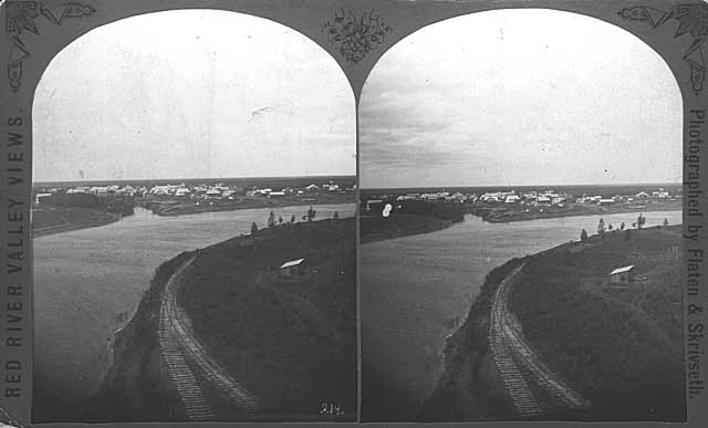
*NOTE: I take exception to this - St.Vincent, although not an 'official' town at this time, is part of the trading posts/forts around Red/Pembina Rivers and has been for many years before this time...most acknowledge that our area is one of the oldest settlements in the upper midwest...

1848 - Wisconsin admitted into the union as a state, leaving residents of the area between the Mississippi and St. Croix rivers (current day eastern Minnesota) without a territorial government or legal system.

1849 - Minnesota Territory formed with present day eastern and southern boundaries set. The population amounts to less than 4000 people, not including persons of pure Native-American heritage. Law provides for free public schools to be open to all people between four and twenty-one years of age. Minnesota Historical Society formed to collect, publish, and educate people about Minnesota history. James Madison Goodhue begins publishing Minnesota's first newspaper, the Minnesota Pioneer.

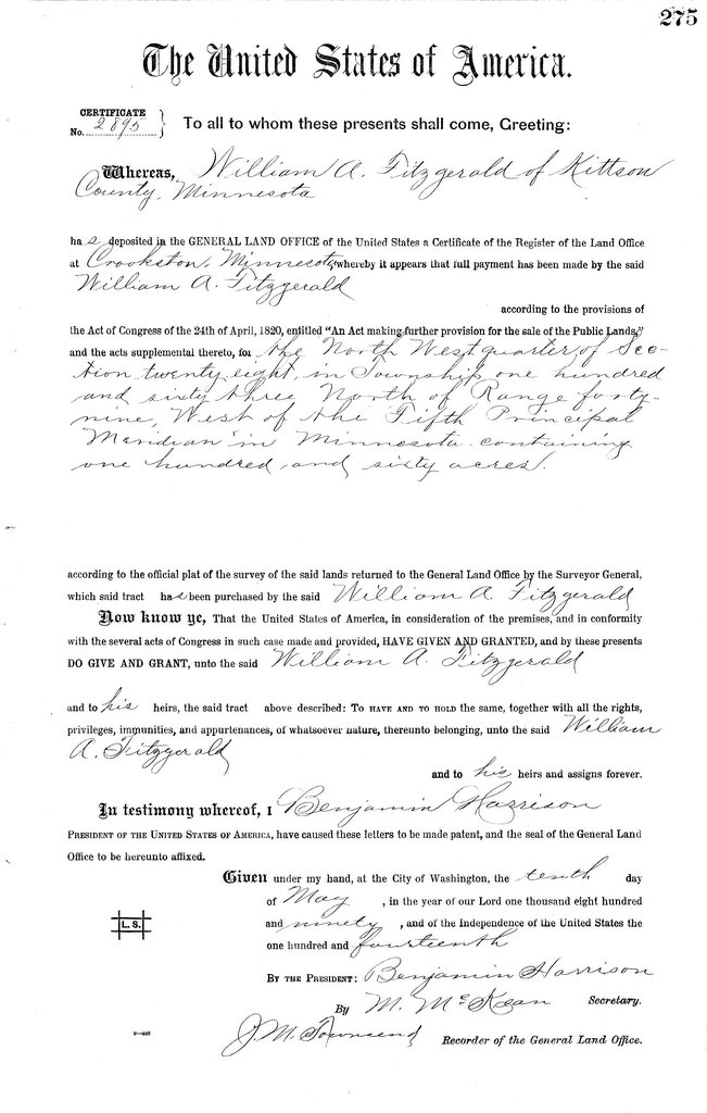
1850 - Treaties concluded at Traverse des Sioux and Mendota with the Dakota Indians whereby the Dakota ceded their lands east of the Red River, Lake Traverse, and the Big Dakota River and south of a boundary line between the Dakota and Chippewa in 1825. In return the Dakota received $1,665,000 US, $1,360,000 of which was set into a trust fund, of which the interest would be distributed to chiefs partly in cash, partly in supplies, and partly in education and civilization funds. The vast majority ended up being used to pay off Indian debts to white traders. Wheat becomes a major crop in Minnesota.

1851 - Charter granted to the University of Minnesota, the first collegiate institution in the territory.

1853-1857- Population explosion occurs in Minnesota from 40,000 people in 1853 to approximately 150,000 people in 1857.

1854 - St. Paul becomes a city with a total area of four square miles.

1855 - Die Minnesota Deutsche Zeitung (The Minnesota German Newspaper), Minnesota's first non-English newspaper, rolls off the press for the first time in St. Paul.

1857 - The Dred Scott Decision is rendered by the United States Supreme Court, where a Missouri slave, Dred Scott, sued for his freedom based in part upon his residence in Minnesota. Amidst the sectional and racial animosity sweeping the nation, the court ruled Scott remained a slave. The residents of the Minnesota territory ratify the state constitution almost unanimously. The Panic of 1857 sends prices skyrocketing. Banks bust and businesses fail. Depression lingers until 1861.

1858 - Newspaper promotion of the Minnesota Territory prompts over one thousand steamboat arrivals in St. Paul, filled with settlers. On May 11 Minnesota becomes the thirty-second state admitted to the Union of the United States of America. State seal adopted by the Minnesota Legislature.

1858-1859 - Henry Sibley instated as first governor of Minnesota.

1859 - First Minnesota State Fair held.

1861 - Civil War of the United States begins. Minnesota volunteers one thousand men for service in the Union Army. Minnesota eventually provides 24,000 men for service in the Union Army for fighting in the Civil War or the Indian Outbreak.

1862 - The Dakota Conflict sweeps across Minnesota with a series of attacks motivated by hungry Dakota enraged by the failure of land treaties and unfair fiscal
practices of local traders. By the end of the conflict 486 white settlers would be dead. On December 26 thirty-eight Indians were hung at Mankato. Minnesota's first railroad is completed, connecting Minneapolis and Saint Paul.

1863 - At the Battle of Gettysburg the First Minnesota Regiment makes a heroic charges, losing 215 of 262 men.

1865 - Civil War of the United States ends.

1868 - Mankato receives a city charter. The Minnesota Legislature authorizes establishment of the 2nd State Normal School in Mankato (now known as Minnesota
State University, Mankato).

1873 -A three-day blizzard hits Minnesota in January, killing seventy Minnesotans.

1878 - 68.98% of tilled land in Minnesota devoted to wheat production, the high point for wheat farmers in Minnesota. After five consecutive summers of devastating infestations of Rocky Mountain Locusts (called the great Grasshopper Plague) which thrived on wheat, farmers decided to diversify, and wheat production was slowly replaced by other crops and dairy farming. A massive explosion in a Minneapolis flour mill kills 18.

1880 - Telephone communication begun between St. Paul and Minneapolis.

1881 - St. Paul is destroyed by fire.

1883 - Mayo Clinic founded by Dr. William Worrall Mayo in Rochester, Minnesota after a tornado sweeps through Rochester, killing 35. With his two sons, Dr. William
James Mayo and Dr. Charles Horace Mayo, he begins a clinic world-renowned for
its dedication to the latest advances in medicine and surgical procedures.

1884 - Minnesota iron ore begins to be exported heralding the dawn of iron mining in Minnesota. Over the next two decades mines spring up on the Mesabi, Cuyuna, and Vermilion iron ranges, spurring the rapid growth of mining cities such as Evelyth, Chisholm, Virginia, and Hibbing, Minnesota as well as the port cities of Duluth, Minnesota and Superior, Wisconsin.

1886 - Sauk Rapids is flattened by a tornado. Seventy-nine people die. St. Paul holds its first winter carnival.

1887 - St. Paul hosts the first ski tourney in the Midwest.

1888 - Western Minnesota receives a major blizzard on January 12 which takes 109 lives.

1890s - Electric streetcars become commonplace in large Minnesota cities.

1893 - The Minnesota state flag, designed by Amelia Hyde Center of Minneapolis, is accepted by the Minnesota Legislature. Virginia, Minnesota destroyed by fire.

1894 - A massive forest fire caused by clear-cut logging debris encompasses Hinckley, Minnesota and several other nearby communities. Over four hundred die.

1898 - The Spanish-American War begins. Minnesota, the first state to volunteer, raises four regiments, one of which serves in the Philippines. Disease proves to be the biggest killer, with combat fatalities accounting for only four Minnesota soldier deaths. Farmer Olof Ohman finds a stone tablet with runic carvings on it in his field near Kensington, Minnesota. The runes indicate a party of Viking explorers passed through that area in 1362. Initially considered a hoax, it was accepted by the Smithsonian Institution in 1948. Opinions differ, but most academic sources today doubt its veracity.

1899 - Minnesota's lumber industry reaches its peak. By 1930 only 1/3 of the state would remain forested, with very little of that virgin growth.

20th Century

1900 - Virginia, Minnesota destroyed by fire again.

1902 - Approximately twelve automobiles appear in Minneapolis. Tom Shevlin, son of a lumber magnate, gets arrested for violating the ten mile per hour city speed limit.

1905 - John A. Johnson, Minnesota's first native-born governor, elected to the first of his three terms. Lumber production peaks in Minnesota.

1906 - William Williams is hanged in the county jail in St. Paul on February 13, ending capital punishment in Minnesota.

1908 - Chisholm, Minnesota is virtually obliterated by a late summer forest fire.

1914 - World War I begins. Minneapolis becomes the home of the Federal Reserve Bank.

1917 - The United States of America enters World War I. 118,497 men from Minnesota serve in the war.

1918 - World War I ends with 1,432 Minnesotans in uniform giving their lives for their country. The new Farmer-Labor Party becomes the second largest political party in Minnesota and capitalizes on the rural depression which plagues Minnesota until 1824 to gain a broad base of support. Influenza spreads to Minnesota. Labeled a "pandemic of influenza", this disease managed to kill 7,521Minnesotans in 1918 and more than 4,200 over the course of the following two years. Cloquet and Moose Lake, Minnesota are destroyed when seventy mile an hour winds change minor forest fires into major conflagrations.

1919 - Minnesota ratifies the 19th amendment (women's suffrage) to the United States constitution. A tornado strikes Fergus Falls, Minnesota killing 59.

1920 - Minnesota authors receive international recognition. Main Street, written by Sinclair Lewis, earns national recognition as he takes a critical look at his hometown of Sauk Centre, Minnesota. By the end of the decade he had won the Nobel Prize for literature after a string of four more novels won international acclaim. St. Paul native F. Scott Fitzgerald receives much acclaim for his book This Side of Paradise. By 1925 he had published five more works, all focusing on the extravagance and despair of the 1920s in the United States.

1921 - WLB, the first Minnesota radio station, formed at the University of Minnesota.

1927 - Charles Lindbergh, a native of Little Falls, Minnesota, flies solo across the
Atlantic Ocean from New York to Paris.

1929 - Great Depression begins in the United States. The depression begins in Minnesota with the bankruptcy of key employers in Minneapolis and quickly spreads to the rest of the state.

1930-1935 - Over 1/2 of iron ore extracted from the earth originates in Minnesota mines.

1931 - Ancient remains of 20,000 year old skeleton dubbed "Minnesota Man" found in Otter Tail County, Minnesota.

1933 - "Browns Valley Man" remains, estimated to be 8,000 - 10,000 years old, discovered in Brown County, Minnesota.

1934 - Edward G. Bremer of St. Paul kidnapped by the Barker-Karpis gang. His ransom of $200,000 US is one of the largest ransoms in the United States up to that time. By 1936 the kidnappers had been caught and convicted. "Public Enemy Number 1" John Dillinger has a gun battle with FBI agents in St. Paul on March 11 and escapes.

1936 - Temperatures remain below zero for a record thirty-six days beginning on January 18. Later in the summer Moorhead, Minnesota ties a state record high official temperature of 114 degrees Fahrenheit, previously set in Beardsley, Minnesota in 1927.

1939 - A hockey game in the Duluth Amphitheater is interrupted when the ceiling collapses under the weight of snow. No deaths are reported.

1940 - The Armistice Day Blizzard strikes Minnesota leaving a 16.8 inches of snow in twenty four hours. Winds that day exceed thirty two miles per hour with gusts over sixty miles per hour. Forty-nine Minnesota residents die and over $1,500,000 US worth of property is damaged as a result of the storm.

1941 - First tax on taconite, a black magnetic iron-bearing ore, in effect in Minnesota. The United States enters World War II. Singer Bob Zimmerman
(Bob Dylan) born in Duluth.

1944 -The Democratic and Farmer Labor parties merge to form the Democratic-Farmer-Labor Party.

1945 - World War II ends with 6,255 American servicemen from Minnesota giving their lives for their country. The Minnesota state song, "Hail! Minnesota" is adopted by the Minnesota Legislature.

1948 - Minnesota's first television station, KSTP, goes on the air.

1950 - The Korean War begins. By the time of the armistice in 1953, 688 Minnesotans had died in the fighting.

1951 - Over 82% of iron ore extracted from United States mines during this year originates in Minnesota.

1954 - Coya Knutson becomes the first Minnesota woman elected to the Congress of the United States.

1958 - Prince Rogers Nelson (the artist formerly known as Prince) born in Minneapolis.

1959 - The opening of the St. Lawrence Seaway makes Duluth accessible to the Atlantic Ocean.

1963 - Last iron ore shipment leaves the Vermillion iron range.

1964 -Minnesota Senator Hubert Humphrey elected vice-president of the United
States as the running-mate of president Lyndon Johnson. Conventional American ground forces are introduced into Vietnam.

1968 - Senator Eugene McCarthy of Minnesota begins his bid for the presidency by easily winning the New Hampshire presidential primary. Minnesota Senator Hubert Humphrey also runs for president that year, narrowly losing to Richard Nixon. The American Indian Movement (AIM) is founded in Minneapolis to combat racism.

1969 - Warren Burger, a native of St. Paul, named to the Supreme Court of the United States.

1970 - Minnesotan Harry Blackmun named to the Supreme Court of the United States. He would later write the majority opinion in the case of Roe v. Wade, which legalizes abortion.

1975 - The last American military personnel leave Vietnam with the evacuation of the United States embassy in Saigon, completely ending American involvement in Vietnam and the Vietnam War. 1,053 Minnesotans gave their lives over the course of the war.

1976 - Jimmy Carter becomes the 39th president of the United States with Minnesota Senator Walter Mondale as his vice-president. Mondale would later run for president in 1984, losing to Ronald Reagan.

1977 - Rosalie Wahl becomes the first woman justice in the Minnesota Supreme Court.

1980 - Last iron ore shipment leaves the Cuyuna iron range.

1982 - A total of 34.3 inches of snow falls on the Twin Cities on January 20 and 22. Taconite mining emerges as the future employment source for the iron range, with 12,000 workers. The subsequent depression and trend toward mechanization halve that number by 1995.

1984 - Last iron ore shipment leaves the Mesabi iron range, effectively ending Minnesota's direct iron ore industry and confirming a difficult depression on the iron range.

1987 -The Minnesota Twins win the World Series.

1988 - The Indian Gaming Regulatory Act, passed to promote tribal economies, causes a boom in Indian casinos and gambling in Minnesota. By 1990 Minnesota ranks fourth in the nation in per capita gambling sales. Minnesota hit by a record setting drought.

1990 - Soviet President Mikhail Gorbachev visits Minnesota.

1991 - Operation Desert Storm occurs with approximately 11,000 Minnesotans in uniform helping to defeat Iraq and liberate Kuwait. The Minnesota Twins win the World Series. A record-breaking snowstorm hits Minnesota on November 1 depositing twenty-four inches of snow in twenty-four hours.

1996 - Coldest official temperature ever recorded in Minnesota set at -60 degrees Fahrenheit on February 2 near Tower, MN.

1998 - Minnesota becomes home to largest ethnic Hmong population in America.

Wednesday, December 21, 2005

Hometown Trivia


Did you know...?

"...which later became known as the Red River Cart, first made its appearance in 1801 at Pembina Post, at the confluence of the Red and Pembina Rivers, according to the journal of Alexander Henry, the younger, which is the earliest record of this cart. Pembina Post was within the old realm of Rupert's Land, the land grant of Charles II to the Hudson's Bay Co. in 1670."

- Manitoba Historical Society


Measure & Re-Measure

It took most of the 19th century to establish the US/Canadian border. Several surveys, much talking behind closed doors, measure and re-measure...

In 1872, Lindsay Russell, later to be in charge of the Special Survey, in co-operation with the Chief Astronomer to the British members of the International Boundary Commission had established, by telegraphic signals, the difference in longitude between the astronomic station on the 49th parallel at Pembina and the Observatory at Chicago. The first work of the Survey in 1874 was to determine the longitude of the point of intersection of the Winnipeg Meridian with the International Boundary. Thus, with the known relative position of Chicago and Greenwich, and by reference to the Pembina station, the necessary connection of all subsequent surveys with Greenwich was established.

- Manitoba Historical Society

100 Years Ago...

Ever wonder what St. Vincent/Pembina area looked like a century ago?

In 1908, if you wanted to go from St. Vincent to Pembina, you had to use the river ferry. When my grandfather was courting my grandmother, he was the town drayman, and was often working with the ferryman in transporting cargo to town businesses, as well as mail items to the postmaster for delivery...

Here we have a street scene in a residential area of 1910 Pembina. The 'street' is not much more than a track in the dirt. Tales of having to deal with muddy wheels fell on my young, deaf ears from my mother and grandmother. Now when I see the photos as an adult, it's beginning to sink in how primitive things were and what they had to deal with just to get around. We are SO spoiled today...

By the way, according to U.S. Census records, St. Vincent's population at the turn of the last century was 349 (at the last census in 2000, it was 170...)

Monday, December 19, 2005

Selkirk Settlement

The location of 'Fort' Pembina (Post) is incorrectly shown. The dot representing its location should be above the Pembina River at its northwest junction with the Red. The Hudson's Bay post opposite the mouth of the Pembinais shown as 'Old Fort'Shown at left is the Selkirk Settlement circa 1811, the year the land was granted to Lord Selkirk.

At that time, there was no established international boundary between what would become the United States, and Canada. In fact, what would later become the province of Manitoba, and the states of North Dakota and Minnesota, as well as the cities of Winnipeg, Grand Forks, and the towns of Pembina and St. Vincent - while marked on the map - are all still territories, forts, settlements, and trading posts.


The fur trade companies each had a fort of sorts at the junction of the Red and Pembina rivers, the Hudson's Bay on the east bank of the Red, the Northwesters on the north bank of the Pembina. The above sketch (after Peter Rindisbacher - 1822) shows the Nor'Westers' Pembina Post (r) and Fort Daer (l) where the second party of settlers stayed during the winter of 1812-13. - Manitoba Historical Society

Saturday, December 10, 2005

Early Photographs

Click to see bigger From Minnesota Historical Society, this shows the border marker between Canada and USA. I often saw this marker as we would go over to Emerson to shop, go to the hospital, visit the veterinarian, go to my piano lessons, etc.
---------------
Photograph Collection
Location No. FM6.67 p1
Negative No. 24996
Title: Monument 833 near Emerson, Manitoba (looking west), Red River in background
Date: 5/24/1972
Medium: Photograph

Here are a few more of a new batch of photos I uploaded to my St. Vincent Memories FLICKR group today. You can access the full collection via the link on the sidebar to the right on this page...

Click to see biggerThis is a stereograph of Pembina & St. Vincent in the 1870's, taken by Flaten & Skrivseth, the "...official Photographers of the St. Paul, Minneapolis and Manitoba R.R." (precursor to the Great Northern Railroad...) Pembina is seen in the background at the fork of the Pembina River, a tributary, and the Red River of the North. In the foreground is edge of what will be St. Vincent; there are a few brave souls there already, and the Northern Pacific railroad has already made itself known. Close to this area is where the first bridges were built later in the century. For now, people had to use private boats to cross - canoes and such - and later there was a ferry. My grandfather helped with the ferry, and was also the local drayman for a period of time...
Click to see bigger


An early scene of barges on the Red River...

Sunday, December 04, 2005

First Person Accounts

I've been gleaning every reference to my village and surrounding area that I can from the historical record, including those written by regular people who travelled through the area for various persons, during the early years. It gives a fascinating insight into what life was like then...NOTE: I have found evidence in the historical record that the tracks into St. Vincent were to be eventually joined to another railroad over the Red River from the Pembina side, but that never happened. Instead, the line in Pembina stayed there, and went north To Winnipeg…

From MINNESOTA IN 1871:

It is, indeed, the intention of the Northern Pacific Road to construct from the point of junction of the St. Paul and Duluth arms, on the Red River, a branch road, northward to Pembina, and it cannot be long ere it will be continued to Hudson's Bay.


From CANADA, CHRONICLE OF OUR DOMINION:

Other waves of voluntary immigration followed--Ulster Presbyterians, driven out by the attempt of England to crush the Irish woolen manufacture, and, still later, Highlanders, Roman Catholic and Presbyterian, who soon made Gaelic the prevailing tongue of the easternmost counties. By 1767 the colony of Nova Scotia, which then included all Acadia, north and east of Maine, had a prosperous population of some seven thousand Americans, two thousand Irish, two thousand Germans, barely a thousand English, and well over a thousand surviving Acadian French. In short, this northernmost of the Atlantic colonies appeared to be fast on the way to become a part of New England. It was chiefly New Englanders who had peopled it, and it was with New England that for many a year its whole social and commercial intercourse was carried on. It was no accident that Nova Scotia later produced the first Yankee humorist, "Sam Slick."

From COLLECTION OF MN HISTORICAL SOCIETY:


It is interesting to note the rapid growth of population and wealth that has taken place in the Red River valley within thirty years. In that time many cities, villages, and hamlets, have been established and builded, some of which have grown until they may fairly be denominated as magnificent and metropolitan. It is hardly needed to name Fargo and Moorhead (one city in a commercial and social sense, although situated in different states); Grand Forks and East Grand Forks, similarly situated; and likewise Wahpeton and Breckenridge. Pembina and St. Vincent also are somewhat similarly situated, though more distant from each other. Besides there are Crookston, on the Red Lake river, Hallock, Warren, Ada, and Barnesville, in Minnesota, Grafton and Hillsboro, in North Dakota, and many others of less note in both states.

In 1870 the population of the twelve counties was about 1,000. In 1880 it was 56,000. In 1890 it was 166,000. In 1900 it is estimated to be 350,000. The valuation of property in the valley in 1870 was zero. At this date it is estimated at not less than $100,000,000; and I am speaking of assessed valuation, which is, as a matter of course, far short of actual valuation.
-----

On May 20, the Council went into committee of the whole for the further consideration of this bill, and after some time spent therein reported an amendment, striking out all after the enacting clause, and inserting an omnibus railroad bill vesting the land grant in four corporations. The amendment was agreed to and the title changed to correspond. The next day the message of the Council announcing its concurrence in the House bill to encourage the destruction of gophers and blackbirds, with an amendment, was received by the House. A ruling of Speaker Furber that the so-called amendment was not truly such, but was entire new matter, was appealed from effectively, by a vote of 28 to 8. There were but three negative votes on concurrence. The act thus passed and promptly approved, forms chapter I of the Session Laws of 1857, entitled "An Act to execute the trust created by an Act of Congress; and granting certain Lands to Railroad Companies therein named."

The division into three sub-chapters indicates the make-up of the act by simple assemblage. The first of them incorporates the Minnesota and Pacific Railroad Company, and empowers it to build from Stillwater via St. Paul and St. Anthony to Breckenridge on the Sioux Wood river, with a branch from St. Anthony via Anoka, St. Cloud and Crow Wing to St. Vincent, near the mouth of the Pembina river.

From FIRST YEARS OF MINNESOTA:

The editor of the St. Anthony Express gives an incident in his experience, while passing this town, of which we are reminded, and which we quote:

"While sitting upon the deck," he says, "enjoying the delightful breeze and the flavor of a mild Havana, we were accosted by a young man of most genteel address, and faultless moustache, in blandest terms, requesting the favor of lighting his cigar by our own. Assuring him that it afforded us great pleasure to grant him the favor, he drew up a vacant chair on our left—conversation once opened, was not difficult of a continuance, under such circumstances, with so well-informed a person our as new acquaintance seemed to be; especially in regard to Minnesota affairs; for, to believe his own account, he had traveled over nearly every part of the territory, from Iowa to Pembina, from Superior to the Rocky Mountains. He had slain buffalo on the plains, elk on the Red River of the North; dug ores on Superior, trapped with Kit Carson, and sold peltries to the Fur Company in St. Paul...
-------
INHABITANTS OF PEMBINA

Still further up, and extending to the British lines, is Pembina, the most northern county, where one finds a busy, scattered population, of English, French and half-breeds. The latter are mostly living in the manner of their red ancestors, without fixed habitations, abiding for a time in lodges, and in character and habits evincing little of their Anglo-Saxon extraction.

The majority of the half-breeds of this region subsist chiefly by the avails of the hunt. A company of hunters are usually absent from their homes from one to three months, and three or four days are consumed in reaching the heart of their hunting grounds. Their women always accompany them to take charge of the spoils, prepare the food, and perform any other service required by their husbands.

The white traders have mostly married in the Indian country, and their children have few of the benefits of civilization; hence the mixed, uncultivated race that flood the land. Some of these men, however, to their honor be it said, are devoting great care to the education and improvement of their offspring, thus supplying, as far as possible, the want of cultivation and intelligence in their Indian mothers.

They are, as a race, brave and hardy; fine horsemen and skillful marksmen, and might be valuable citizens did they not, as a whole, repudiate civilization. In religion they are Romanists, and strongly attached to its forms and ceremonies.

Efforts have been made to introduce evangelical religion amongst them, and not wholly without success. The Baptist Home Mission Board appointed Rev. James Tanner, a half-breed Chippewa, as their missionary, who made long and fatiguing journeys…

From MINNESOTA AND DACOTAH, DESCRIPTIVE LETTERS (1856):

There is a settlement at Pembina, where the dividing line between British America and the United States crosses the Red River of the North. It didn't extend there from our frontier, sure enough. If it extended from anywhere it must have been from the north, or along the confines of that mystic region called Rainy Lake. Pembina is said to have about 600 inhabitants. It is situated on the Pembina River. It is an Indian-French word meaning cranberry. Men live there who were born there, and it is in fact an old settlement. It was founded by British subjects, who thought they had located on British soil. The greater part of its inhabitants are half-breeds, who earn a comfortable livelihood in fur hunting and in farming. It sends two representatives and a councillor to the territorial legislature. It is 460 miles north-west of St. Paul, and 330 miles distant from this town. Notwithstanding the distance, there is considerable communication between the places. West of Pembina, about thirty miles, is a settlement called St. Joseph, situated near a large mythological body of water called Miniwakan, or Devil's Lake; and is one of the points where Col. Smith's expedition was intending to stop. This expedition to which I refer, started out from Fort Snelling in the summer, to explore the country on both sides of the Red River of the North as far as Pembina, and to report to the war department the best points for the establishment of a new military post. It is expected that Col. Smith will return by the first of next month; and it is probable he will advise the erection of a post at Pembina. When that is done, if it is done, its effect will be to draw emigrants from the Red River settlement into Minnesota.

Now let me say a word about this Red River of the North, for it is beginning to be a great feature in this upper country. It runs north, and empties into Lake Winnipeg, which connects with Hudson's Bay by Nelson River. It is a muddy and sluggish stream, navigable to the mouth of Sioux Wood River for vessels of three feet draught for four months in the year. So that the extent of its navigation within the territory alone (between Pembina and the mouth of Sioux Wood River) is 417 miles. Buffaloes still feed on its western banks. Its tributaries are numerous and copious, abounding with the choicest kinds of game, and skirted with a various and beautiful foliage. It cannot be many years before this magnificent valley shall pour its products into our markets, and be the theatre of a busy and genial life.

One of the first things which drew my attention to this river was a sight of several teams travelling towards this vicinity from a north-westerly direction. I observed that the complexion of those in the caravan was a little darker than that of pure white Minnesotians, and that the carts were a novelty. "Who are those people? and where are they from?" I inquired of a friend. "They are Red River people, just arrived—they have come down to trade." Their carts are made to be drawn by one animal, either an ox or a horse, and are put together without the use of a particle of iron. They are excellently adapted to prairie travelling. How strange it seems! Here are people who have been from twenty to thirty days on their journey to the nearest civilized community. This is their nearest market. Their average rate of travelling is about fifteen miles a day, and they generally secure game enough on the way for their living. I have had highly interesting accounts of the Red River settlement since I have been here, both from Mr. Ross and Mr. Marion, gentlemen recently from there. The settlement is seventy miles north of Pembina, and lies on both sides of the river. Its population is estimated at 10,000. It owes its origin and growth to the enterprise and success of the Hudson's Bay Company. Many of the settlers came from Scotland, but the most were from Canada. They speak English and Canadian French.


… I think the facts which I have herein hastily set down will dispel any apprehension as to the successful cultivation of the soil in the northern part of the territory. It has a health-giving climate which before long, I predict, will nourish as patriotic a race of men as gave immortality to the noble plains of Helvetia. There is one thing I would mention which seems to auspicate the speedy development of the valley of the North Red River. Next year Minnesota will probably be admitted as a state; and a new territory organized out of the broad region embracing the valley aforesaid and the head waters of the Mississippi. Or else it will be divided by a line north and south, including the western valley of that river, and extending as far to the west as the Missouri River. I understand it will be called Dacotah, though I at first thought it would be called Pembina.

What will it be called? If the practice hitherto followed of applying to territories the names which they have been called by their aboriginal inhabitants is still adhered to, this new territory will have the name of Dacotah. It is the correct or Indian the name of those tribes whom we call the Sioux; the latter being an unmeaning Indian-French word. Dacotah means "united people," and is the word which the Indians apply to seven of their band.1

1 The following description of the Dacotah is based on observations made in 1823. "The Dacotahs are a large and powerful nation of Indians, distinct in their manners, language, habits, and opinions, from the Chippewas, Sauks, Foxes, and Naheawak or Killsteno, as well as from all nations of the Algonquia stock. They are likewise unlike the Pawnoes and the Minnetaroes or Gros Ventres. They inhabit a large district of country which may be comprised within the following limits—From Prairie de Chien, on the Mississippi, by a curved line extending east of north and made to include all the eastern tributaries of the Mississippi, to the first branch of Chippewa River; the head waters of that stream being claimed by the Chippewa Indians; thence by a line running west of north to the head of Spirit Lake; thence by a westerly line to the Riviere de Corbeau; thence up that river to its head; near Otter Tail Lake; thence by a westerly line to Red River, and down that river to Pembina; thence by a south-westerly line to the east bank of the Missouri near the Mandan villages; thence down the Missouri to a point probably not far from Soldier's River; thence by a line running east of north to Prairie du Chien.This immense extent of country is inhabited by a nation calling themselves, in their internal relations, the Dacotah, which means the Allied; but who, in their external relations, style themselves the Ochente Shakoan, which signifies the nation of seven (council) fires. This refers to the following division which formerly prevailed among them, viz.:—1. Mende-Wahkan-toan, or people of the Spirit Lake.2. Wahkpa-toan, or people of the leaves.3. Sisi-toan, or Miakechakesa.4. Yank-toan-an, or Fern leaves.5. Yank-toan, or descended from the Forn leaves.6. Ti-toan, or Braggers.7. Wahkpako-toan, or the people that shoot at leaves.—Long's Expedition to Sources of St. Peter's River, vol. 1, pp. 376, 378.

From MINNESOTA PIONEER SKETCHES:

There was a time, many years ago, when I believed the sun to rise just beyond the eastern border line of the State of Maine. After I had come to Minnesota in 1855, I was fully convinced of the fact that the self same sun set somewhere in the vicinity of Sauk Rapids, that being as far up the Mississippi as the steamers could run, before they must turn around and paddle back, assisted greatly on their homeward trip by the swiftly running current.

Later on, the arrival of a caravan of Red River carts, loaded with furs from Pembina, brought the intelligence that there were people and plains and sunsets far beyond the afore-mentioned "Rapids." This statement, however, was so in excess of anything I had even dreamed of that I could not bring myself to place any credence in the report, and so held to the belief of carlier life. But as the years multiplied my ideas began to expand, and I had about made up my mind to accept the theory of a wonderful country far to the north and west of Minneapolis. According to report, it seemed that it would be necessary to make a good long "hop, skip and jump" over a desert vast in extent and irredeemable in character, before that country could be reached. As is usually the case with wide awake people, there were found those, who, guided by a "Fisk" or "Bottineau," were ready to venture and explore this region, and they were numbered by the hundreds. For the prospect of an abundance of "filthy luere" they were willing to risk their lives in crossing plains, fraught with unknown dangers to the Black Hills, the land of gold. This was in 1865 and 1866.

From SETTLER’S GUIDE FOR THE U.S.A. & CANADA, 1862:

For all the great Northern staples—wheat, corn, oats, barley, potatoes, sheep, and cattle—the range and duration of the summer heats form the decisive condition, and as they have been given, prove conclusively the climatic adaptation of the great valley of the Red River, in the northern part of the State, to grain culture, for a distance of 380 miles, and the great valley of the Saskatchawan, whose mighty volume rolls for 1,400 miles from the base of the Rocky Mountains and through Nelson River, discharging itself into Hudson Bay.

Red Lake, and Sioux and Wood rivers in Minnesota, and Shayenne and Pembina in the new Territory of Dacotah, are the principal tributaries of the Red River; and Lake Winnipeg, 264 miles long and averaging 35 miles wide, is the common reservoir of these confluent streams. Throughout nearly the whole slope which forms the undulating prairies of the Winnipeg, is found a rich growth of grasses and herbage, on which countless herds of buffaloes find their favorite ranges in winter. The luxuriant summer climate and exuberant verdure of this secluded basin (the Winnipeg basin), with its sharply defined hills or mountains on the east and north, 5,000 feet above the sea, repeat on a magnificent scale along its borders the abrupt climatic contrasts of the Swiss valleys, whose green summers are girdled by the icy summits of the Alps.

The Red River valley winter season is thus described by a sojourner for several years in that region: "But though the winter of this region is a period of intense cold, during which the mercury sometimes freezes, its effects upon the physical system are mitigated by a clear, dry atmosphere, such as makes the winters of this part of northern Minnesota the season of much enjoyment, sleighing, etc."

The buffalo winter here in myriads on the nutritious grasses of its prairies. The half–breeds and Indians camp out in the open plain during the whole winter, with no shelter but a buffalo–skin tent, and abundance of buffalo–robes to sleep on. The horses. of the settlers run at large in the winter, and keep in good order on the long, dry grasses they find in the woods and bottoms. This country, or the part of Minnesota I have just now described, is in about latitude 50° north, or 10° north of the latitude of New York city; it is not, however, much resorted to by settlers at present, as the more warm and open valleys and prairies of the southern part of the State are only partially and thinly settled yet, and have millions of acres of fine oak openings and prairie land yet unsold.

From WOMAN ON THE AMERICAN FRONTIER:

Minnesota well deserves the name of the pioneer's paradise. Occupying as it does that high table-land out of which gush into the pure bracing air, the thousand fountains of the Father of waters and of the majestic Red river; studded with lakes that glisten like molten silver in the sunshine; shadowed by primeval forests; now stretching out in prairies which lose themselves in the horizon; now undulating with hills and dales dotted with groves and copses, nature here, like some bounteous and imperial mother, seems to have prepared with lavish hand a royal park within which her roving sons and daughters may find a permanent abode.

The country through which the Red river flows from Otter Tail lake towards Richville, is unsurpassed for rural beauty. Trending northward it then passes along towards Pembina, a border town on our northern boundary, through a plain of vast extent, dotted with groves of oak planted as if by hand. Voyaging down this noble river in midsummer, between its banks
embowered with wild roses we breathe an air loaded with perfume and view a scene of wild but enchanting loveliness. Here summer celebrates her brief but splendid reign, then lingering for a while in the lap of dreamy, balmy autumn, flies at length into southern exile, abdicating her throne to winter, which stalks from the frozen zone and rules the region with undisputed and rigorous sway.

In the month of March, 1863, a party of four hunters set out from Pembina, where they had passed the winter, and undertook to reach Shyenne, a small trading post on the west bank of the Red river, in the territory of Dakota. A partial thaw, followed by a cold snap, had coated the river in many places with ice, and by the alternate aid of skates and snow-shoes, they reached on the third evening after their departure, Red Lake river in Minnesota, some eighty miles distant from Pembina. Clearing away the snow in a copse, they scooped a shallow trench in the frozen soil with their hatchets, and kindling a fire so as to cover the length and breadth of the excavation, they prepared their frugal repast of hunters' fare. Then removing the fire to the foot of the trench and piling logs upon it, they lay down side by side on the warmed soil, and wrapping their blankets around them slept soundly through the still cold night, until the sun's edge showed itself above the rim of the vast plain that stretched to the east. As the hunters rose from their earthy couch and stretched their cramped limbs, casting their eyes hither and thither over the boundless expanse, they descried upon the edge of a copse some quarter of a mile to the south a bright-red object, apparently a living thing, crouched upon the snow as if sunning itself. Rising simultaneously and with awakened curiosity they approached the spot. Before they had taken many steps the object disappeared suddenly. Fixing their eyes steadily on the point of its last appearance, they slowly advanced with cocked rifles until they reached a large tree with arching roots, around which were the traces of small shoeless feet. An orifice barely large enough to admit a man showed them beneath the tree a cave. One of the hunters, peering through the aperture, spied within, a girl of ten years crouched in the farthest corner of the recess, covered with a thick red flannel cloak, and shivering with cold and terror. Speaking kind words to the little stranger they succeeded at length in reassuring her. She came out from her hiding-place, and the hunters with rugged kindness wrapped her feet and limbs in their coats and bore her to the fire. The first words she uttered were, "mother! go for mother!" She had gone away to shoot game the night before, the little girl said, and had not returned.

Two of the hunters hastened back and succeeded in tracing the mother's course a mile up the river to a thicket; there, covered thinly with leaves and with her rifle in her stiffened hand, they found the hapless wanderer, but alas! cold in death. Her set and calm features, her pinched and wasted face, her scantily robed form, mutely but eloquently told a tale of fearful suffering borne with unflinching fortitude. Weak and weary, the deadly cold had stolen upon her in the darkness and with its icy grip had stilled for ever the beating of her brave true heart. Excavating a grave in the snow they decently straightened her limbs, and piling logs and brush upon her remains to keep them from the beasts of prey, silently and sorrowfully left the scene.

Who were these lonely wanderers in that wild and wintry waste! The presence of the rifle and of the large high boots which she wore, together with other circumstances, were evidences which enabled the shrewd hunters to guess a part of their story. It appeared that the family must have consisted originally of three persons, a man and wife, with the child now the sole survivor of the party. Voyaging down the Red river during the preceding summer and autumn; lured onward by the fatal beauty of the region, and deluded by the ease with which their wants could be supplied, they had evidently neglected to provide against the winter, which at length burst upon them all unprepared to encounter its rigors.

From MANITOBA, DESCRIPTION OF TRAVELS (1877-1879):

I have already mentioned Red River and its many windings, which it is needless to allude to here. We passed Grand Forks at midnight on Saturday, and, leaving an order for stages to be sent on in the morning to overtake us, got off the steamer at ten o'clock on Sunday, saving more than a day on the river by driving to Fisher's Landing. The farm, where we went ashore, is owned by an Ontario emigrant. The house is situated in the midst of a beautiful grove of oak and birch, among which grassy avenues, with huge branches meeting overhead, formed roads to the neat farmyards and granaries. A big bell hung on cross poles at the entrance to one of the avenues leading to what was once the rolling prairie, now fields of grain--six hundred acres, without a fence, stump, or ditch to mar the effect. The clear line of the horizon was broken only by another farmhouse, owned by a brother-in-law, whose farm lay beyond. The man told us he had emigrated six years before to Manitoba, and had gone as far as Emerson, where the mud frightened him; and, turning back, he had taken up this land, paying a dollar and a quarter an acre for it, and had succeeded so well, that at the end of the second year it had paid all expenses. Since then he had built a good house and barns, and bought extra stock, and he was putting money in the bank. The only trouble he had was the difficulty of getting men at harvest-time, the farms being too scattered to be able to follow the Ontario plan of "Bees;" [Footnote: "Bees" are gatherings from all the neighbouring farmhouses to assist at any special work, such as a "threshing bee," a "raising" or "building bee." When ready to build, the farmer apprises all his neighbours of the date fixed, and they come to his assistance with all their teams and men, expecting the same help from him when they require it. They have "bees" for everything, the men for outdoor work, and the women for indoor; each as quilting or paring apples for drying, when they often pare, cut, and string several barrels in one afternoon. When the young men join them, they finish the evening with high tea, games, and a dance.] and he often had to work eighteen or twenty hours running, the late and early daylight, as well as the bright, clear moonlight, helping him.

The Yankee emigration agents have a powerful assistant in the Pembina mud, in persuading Canadian emigrants to remain in Dakota or Minnesota. But if these emigrants were less impatient, or less easily persuaded, they would find quite as good, if not better land, in Manitoba than on the American side of the line, besides being under our own Queen and laws.

The stage was so long in coming, that some of our party took advantage of the farmer's offer to drive them to Fisher's Landing for seventy five cents a head. We were not long in following them, and after jolting for an hour and a half over a rough road, most of it through farms, we reached Fisher's. How changed the place was since we stopped there on our way up! We found a uniform row of painted wooden houses, shops, offices, ware rooms, and boarding houses, besides several saloons and billiard rooms. Up the slight hill to the south, where had been rude board
shanties, mud, and chaos, one or two pretty cottages had been built, having green blinds, and neatly arranged gardens and lawns. A medium sized wharf and gravelled banks had arisen where was only a dismal swamp, while away over the prairie lay the iron rails of the St. Vincent and St. Paul extension line, soon to be running in connexion with the Pembina branch of the Canada Pacific at the boundary, when the tedious trip upon Red River can be avoided. The side tracks were full of loaded freight, and cars waiting to tranship at the wharf, the steamer which left Winnipeg two days before we did having only just arrived.