Looking to see if anyone might know or have any more info on the story that might be behind this. As you all know the mighty red is far from mighty right now but I still decided to take my boat down to check things out. Came across what looked to be an old sunken boat of some sort. Brought it up to my dad and he said that his grandparents (Bud and Jean Feick) had said that it was an old steamboat that used to run from Forks to Winnipeg in the late 1800s but had gotten hung up and then just left in the river. They had also said that long ago you were able to see one of the masts sticking out of the water once the red would get lower. It sits about 3½ miles south of Pembina. Obviously most is completely covered with mud and/or missing but you can see about 30ft worth of deck right now. These boards are way bigger than they look in the pictures...
There was much excitement in the group in reaction to the post. Over 70 comments exploded the discussion:
Paul Maloney: What do the nails look like, if any survived? And I think remnants of the boiler would still be there if it was a steamboat.
Jake Cosley: All the main nails used to hold the planks down are ¼x¼" square. There were a few large ½-⅝" round spikes used as well
Julie Lindegard: I will ask my dad Bob Cameron if he has any further info. Dad recalled hearing that Humboldt kids (St. Vincent kids were too far away) would often swim in the river and get on the boat and jump off. I can imagine it provided hours of entertainment for kids! He said that the Bockwitz family found and retrieved the anchor. They contacted my dad to take it to the museum in Lake Bronson at least 30 years ago. That's where it is now.
At Right: Evidence of scorched and burned decking could still be seen, over 140 years later...
Hetty Walker: Chuck always talked about the steamboat, that got hung up …that could be it
Janine Rustad: Talk to DeeDee Bakken---she used to say her dad knew exactly where it sunk
Julie Lindegard: Yes dad mentioned it was near/in the area of the Giffen farm.
Donald Burroughs: Does North Dakota have a historical society? Would be an opportunity to salvage some of the boat, those nails and boiler parts, paddle wheel hardware plus its coordinates to build a story around it.
Brandon Lee Legvold: Three (3) miles above Pembina it says which in Red River terms would be south of town so I would definitely say that is the hull of the Dakota that was found.
Trish Short Lewis: Since it’s only partially burned and witnesses say the ship burned, I think the idea of these being one of the two barges might be right. I reserve final judgment until we hear from DeeDee Bakken (hopefully) on what she recalls her father seeing…
Brandon Lee Legvold: [The source of the quoted newspaper article, which is pictured above, is...] the Worthington (Minnesota) Advance. August 19, 1880. Which oddly enough is today. I found this on Chronicling America.
Trish Short Lewis: Full reference citation for article is The Worthington Advance. [volume] (Worthington, Minn.) 1874-1908, August 19, 1880, Image 1
Image provided by Minnesota Historical Society; Saint Paul, MN (Chronicling America)
On August 26th, I took a field trip up to the wreck site south of Pembina. The person who discovered the wreck - Jake Cosley - was kind enough to take me in his boat to the site, which was on the North Dakota side of the Red River of the North. It was an adventurous ride out, the boat hitting bottom and getting stuck at one point, the water levels were that low (that was why the wreck was revealed in the first place...) After a bit of creative 'jiggling', we broke free and were on our way again.
It was pretty exciting to be at the site of a 140 year old wreck! It became more and more apparent - between the onsite examination of the wood, old hardware, and what could be ascertained on the construction - that this was remnants of one or both of the barges that the Dakota had been towing full of freight, and that the ship was likely down the river a ways on the Minnesota side near the old Giffen farm. All the pieces fit, however - this had to be the wreck of the Dakota, it was the only thing that made sense from the evidence so far.
That said, a proper survey and investigation needs to be done. And to that end, I contacted the State Historical Society of North Dakota's chief archaeologist, Andrew Clark. Andrew was intrigued about the find, and expressed a desire to come in-person to evaluate the wreck. However, as always, there is red tape. Funding, authorizations needed, etc. I had several conversations with him about what I saw, and he explained that at the very least, the location of the wreck needed to be updated. There was erroneous information in some records that needed correction. After my site visit, I was able to give him GPS coordinates of the wreck to update any official records out there. I also notified the Minnesota Historical Society about the wreck's connection to Minnesota (the steamboat itself was likely within Minnesota jurisdiction).
It is my hope that next summer the SHSND can make an on-site visit to document this important vestige of our region's transportation history. Andrew Clark shared this about a similar discovery made on the Missouri River last year; it would be amazing if they could do the same depth of investigation with the Dakota - it is a fascinating slice of our local history, for sure!
Part of the Dakota steamboat barge wreck as revealed during
Summer 2021 low water on the Red River of the North . . .
When we were children, my Mother often talked about her childhood: her parents, her brothers, their home life. She had a fund of stories too about aunts and uncles, many of whom we had never met but whom we came to know through the many retellings. This is often the starting point for family history exploration. One detail frequently mentioned was that her father had farmed in Canada at one point in his life and one of his sons from his first marriage had died tragically by going through the ice on the Red River "near Winnipeg" (read: St. Vincent, Minnesota) and his body had not been recovered until the spring. We knew nothing more than that bare outline of a story. It was not until I began to research my Grandfather's life that I came to discover the full extent of the story of John Thomas Mortimer.
My Grandfather, James Mortimer, was born at the Home Farm, Kirkton of Tealing, in the rural hinterland of Dundee in 1841. He came from generations of farm workers, many of whom had had small-scale tenancies on the Glamis estate, especially at Upper Arniefoul. Although James's father Alexander had moved to nearby Tealing, then to Balbeuchley at Auchterhouse, James returned to Glamis to serve his apprenticeship as a blacksmith with Peter Anderson at the smiddy there. Perhaps looking for more lucrative employment after his time was served, he moved to Dundee to one of its many jute mills, Ladybank Mill, and in 1864 married Ann Russell, a steam loom weaver, in Lochee. They were to have six children before Ann's untimely death from cerebro-spinal meningitis in 1876.
John was the fourth of the children, born on 3 March 1871 at 3 Laing Street, Dundee, becoming the eldest son, as the first-born boy, Samuel, had died aged two in 1867. After Ann's death, James was married for a second time in 1880 to Helen Innes (nee Watson), widow of a blacksmith journeyman. Their marriage certificate provided a surprising piece of new information: James's occupation was given as 'Insurance Agent'. From blacksmith to insurance agent – how had this transformation occurred? My Mother had always favoured the Prudential Assurance Agency because of her father's connection to that company. So I felt it would be worthwhile to approach their Head Office in the hope that they might have some archive material about former employees. Their Archivist was able to provide me with a full account of my Grandfather's career with them – treasure trove indeed!
The history of the company, A Sense of Security: 150 Years of Prudential, gives an idea of how field staff were recruited, being 'only capable men of thorough respectability, and of favourable appearance and address'. In his latter years, my Grandfather continued to demonstrate a lively mind and interest in a wide variety of subjects. It is likely that he had pursued evening class studies as a young man and was eager for self-improvement, thus fulfilling the requirement of being seen as capable.
In the Census of 1881, the family was living at 13 North Wellington Street, Dundee, with father working as an Insurance Agent and Helen established as wife and mother to the five children, all still at home, Maggie (13), Annie (11), John (10), Alexander (8) and William (6), all scholars. Between his initial appointment to the Prudential in 1876 and 1884, James held contracts of employment in Dundee and Forfar, then in February 1884 he was appointed to a position in Airdrie, Lanarkshire, where he was to remain for most of the rest of his life.
By the 1891 Census, James and Helen were living at 13 High Street in Airdrie and had only two of the family still living at home, Alexander aged 18, a schoolmaster, and William aged 16, a letter carrier. The daughters had moved out, perhaps into employment, and John was in lodgings in Glasgow at 113 McAslin Street (St. Rollox) and working as a tailor. His fellow-lodger in the home of John and Mary Mitchell was Peter McPherson, who would become his brother-in-law by marrying his sister Maggie.
A moment of serendipity
I need to digress at this point to explain how it was I came to learn of the Canadian part of the story. What follows is a moment of serendipity. I had joined the Tay Valley Family History Society and being distant from the Research Centre in Dundee, was delighted when an e-mailing group, Tay Valley Bridges, was set up to bring into contact the many members worldwide who were not able to visit Dundee regularly. On one memorable occasion, an online conversation was taking place which involved Winnipeg. On a whim, I posted a request to see if anyone could tell me how to go about tracing the death of a young man named Mortimer by drowning in the Red River, on some unknown date. Back came the reply from fellow-member Susan Bethune, who happened to have in her possession a copy of the Dictionary of Canadian Biography, with an entry about John Thomas Mortimer, tailor and Trade Union activist. And so his story unfolded.
It is by no means clear when John first went to Canada. He was registered as an American citizen in St. Vincent, Kittson County, Minnesota, on 11 June 1906, having 'landed at the port of St. Vincent on or about the month of November in the year eighteen hundred and ninety'. This information seems at least debatable.1 His entry in the 1891 Census in Glasgow is quite clear and credible. There would not be any obvious reason why, having made the journey to the USA or Canada, he should immediately return to employment in Glasgow. His connection with St. Vincent came about through his wife, Lena Cameron, of whom more later. The first mention of him living in Winnipeg is in 1895, when we find him listed as a tailor in the Henderson's Directory and resident at 326 McDermot Avenue, Winnipeg. along with Wm. Mortimer, described as an engineer. The brothers remained at that address for each year until 1898.
The year 1895 certainly does seem significant. My Grandfather James and his wife Helen also travelled to Canada in that year. James resigned from his employment with the Prudential in April 1895 and was awarded a gratuity of £30. He and Helen sailed from Glasgow on 25 April, occupying a second-class cabin on the SS Samaritan, and arrived in Montreal on 8 May. They would then have made their way overland to Winnipeg. Little is known of their time there. James had a farm near Brandon, north-west of Winnipeg, which he eventually sold to a James Fraser in 1897 before returning to Scotland. It was always related within the family that Helen was unwell and yearned to go back home to Scotland. Indeed she died in Airdrie in 1898 and is buried in the New Monkland Cemetery. Grandfather James subsequently married for a third time, to Isabella Ann Power, my Grandmother, and had a new young family of which my Mother was the only daughter.
John's involvement with the Trade Union movement in Winnipeg is well documented. John Hample, in his entry about John Thomas Mortimer in the Dictionary Of Canadian Biography, states: After September 1896 he began a rise to prominence in Winnipeg's working-class movement by helping to rebuild Local 70 of the Journeymen Tailors' Union of America (JTUA), affiliated with the American Federation of Labor (AFL).
Local 70 had originally been formed in 1892 to give the tailors of Winnipeg protection from the sweatshop practices of the men's custom-made tailoring workshops. After a fruitless strike over an attempt by the merchant tailors to cut wages, Local 70 had been adrift. In 1897, JTM was elected its President and promptly set about galvanising the union, urging the City Council to impose conditions in their contracts for the manufacture of clothing and intervening on behalf of factory seamstresses during a strike which led to the establishment of one of the first unions of women workers in Canada.
By 1899-1900, he was President of the Trades and Labor Council of Winnipeg, representing that organisation at meetings of the Trades and Labor Congress of Canada. During this period at the turn of the 20th century, he developed a close association with Arthur W. Puttee, acting as his election agent in a Winnipeg by-election which made Puttee Canada's first independent Labour MP in 1900. Puttee acted as John's best man at his marriage to Lena Cameron on 2 September 1901, immediately after the Labor Day Parade through Winnipeg.
Lena was the daughter of Edmund Cameron and Allis Clow, who had settled in St. Vincent, Minnesota, just south of the Canadian border on the east side of the Red River, having moved out west from Prince Edward Island, and like John she was a labour activist.John had begun to make a name for himself as an uncompromising militant, considered 'impossibilist' by some in his demands for workers' rights and justice, but was highly regarded within trade union circles. He had reputedly been saving money to enable a visit home to Scotland, but a major national strike of the JTUA saw him invest his money into the strike funds, only to be fired from his job, reviled in the press and ultimately blackballed from employment in the tailoring trade in Winnipeg.
The oxcart trail on the open prairie. Photo courtesy Wadena County Historical Society
History of the Woods Branch of the Red River Trails (1844-1870) Written By: John Crandall, Special to Wadena Pioneer Journal |
Commencing in Winnipeg, Manitoba, Canada the Red River Trail squirreled its way down the Red River Valley and down the Minnesota River Valley to Mendota and later St. Paul, Minn. Thus began a half century of commerce between the Selkirk colonies in Manitoba, Canada and St. Paul.
In 1812 Thomas Douglas, fifth Earl of Selkirk was granted thousands of square miles of land in Manitoba where the Assiniboine River and the Red River meet (Winnipeg) by the Hudson Bay Company (HBC), which had been founded in England in 1670. Portions of this land grant extended West and Southwest into what we know today as Minnesota and North Dakota. Selkirk dreamed of establishing an agricultural colony for Scottish settlers in the New World. But the Earle’s dreams would not continue peacefully. It only infuriated the Northwest Fur Company.
With the British traders entrenched in the region around Hudson Bay, the struggle for the soul of the interior of North America and the riches provided by the lucrative fur trade industry began.
The French traders and voyageurs began exploring the Great Lakes and west at the start of the 18th century, establishing many fur posts along the waterways that followed the future Canadian and American boundaries. With the signing of the Treaty of Paris in 1763 ending the French and Indian War (1754-1763) France gave up over a century of control of Canada to England.
With the French relinquishing their claim to Canada, exploration and trade began to expand into the interior of America. First, in 1784 came the reorganization of the Northwest Fur Company (NWC), which sought to challenge the monopoly the Hudson Bay Company had on the fur trade industry. Between 1783 and 1821, there was an immense increase in the amount of bloodshed and open hostility between the HBC and NWC ending only after the two companies merged in 1821. Secondly, came President Thomas Jefferson’s Louisiana Purchase in 1803.
Even after the end of the American Revolution, the northern boundary of the newly formed American States was unclear. The British continued their incursions into the Red River Valley. It wasn’t until after the War of 1812 that America put a total end to the British occupancy of the United States. In order to stop British traders from enticing the Native Americans to continue trading with them, Secretary of War John C. Calhoun convinced Congress to build a contingency of forts along the Mississippi River and West to the Yellowstone River to protect American interest. In 1819 construction of Fort Snelling commenced.
"On the 3rd of August, 1818 - three weeks after the arrival of the missionaries - clouds of grasshoppers descended on the fields, and in a trice devoured nearly everything. The few grains of wheat remaining barely sufficed to seed the garden-bed farms the following spring. To add to the misfortune, the grasshoppers deposited their eggs, thus insuring another scourge the next year..."
"...the grasshoppers had again devastated the fields, this time destroying all vegetation, even to the bark of the trees."
- Father Provencher
During the first two decades of the 19th century the Red River colonists became more disgruntled with the Hudson Bay’s monopolistic control of trade. In addition, several years of grasshopper blights and the inability to obtain seed for planting prompted the residents of the Red River colonies to begin looking south to Fort Snelling. So, in 1821 the first group of Red River settlers migrated to Fort Snelling and were allowed to settle on the Fort Snelling military reservation. This was to be the first of numerous migrations that would use the Red River Trails as an avenue for reaching and establishing trade with American traders at Mendota.
In 1823 Major Stephen Long reached the settlement of Pembina (in what is now North Dakota) while on an explorative mission to determine where the 49th parallel lay. Upon determining the boundary between Canada and U.S., it became clear that Pembina now resided on U.S. soil. So, the tie that binds was broken between the Red River Colonies and Hudson Bay Company.
Throughout the first part of the 19th century little trade flowed south along the Red River and Minnesota River Valleys. The trickle of traffic that did traverse the Red River Trail during this time frame were seeking a safe haven from the horrific violence between HBC and NWFC. Once migration between Pembina and Fort Snelling began in full swing it would peak around 1826, but continued well into the 1830s and 1840s.
"...the fight for the fur trade was suicidal. As competition with the Hudson's Bay Company intensified, the Nor'Westers kidnapped Indian trappers, laid siege to bay posts, terrorized women and children. Dozens of bay men were murdered. The solution, Mackenzie said, was to merge the two companies before they destroyed one other."
When given their royal charter in 1670 the Hudson Bay Company was given total monopolistic control of all commerce occurring within their jurisdiction. As the population in the Red River Valley increased, HBC began placing higher prices on their goods and less compensation for the furs traded. In time, the Red River Colonist began to seek other sources for conducting trade.
Upon arrival of the American Fur Company in the valley, the Red River Colonies’ chance came. With the American Fur Company absorbing the holdings of the Columbia Fur Company in 1827, the American Fur Company acquired full control of the fur posts that the Columbia Fur Company had along the Minnesota and South Dakota border linking them to the Red River Valley.
During the 1830s, with an increasing growth of settlers in the Red River region and increased production of furs and agricultural products the Hudson Bay Company could not keep pace with the economy. This overflow of productivity induced the Colony traders to seek closer connections to the traders located at Mendota.
With an ever-present increase of settlers in and around Fort Snelling, the American government became increasingly concerned. With negotiation of the Treaty of 1837 with the Dakota and Chippewa, large tracts of land were opened east of the Mississippi River for white settlement. With increasing concerns about the number of settlers homesteading on military land, the government, in 1840, concluded a survey of their holdings around Fort Snelling. The results showed many Red River colonists residing on a military reservation. In the end, the Federal Government expelled them from their homes, forcing them across the river to what was to become St. Paul, and eventually the commercial hub for Red River trade.
The Red River Oxcart trail began its journey south from Winnipeg linking with Pembina and then followed a network of trails south on both sides of the Red River and eventually crossing the continental divide at Lake Traverse. Upon arriving at Big Stone Lake, the trail turned eastward and followed the Minnesota River into St. Paul.
The Valley of the Red River traversed by traders from Pembina to St. Paul was land that had been in contention between the Dakota and Chippewa for over a century. The incursion of the Ojibway into Minnesota and Dakota land began in the 1700s. By the early 1800s the Sioux had been pushed south of the Minnesota River. The Dakota still claimed the Long Prairie and Sauk Valleys as their hunting grounds after tragic losses.
With trade beginning to increase between the Red River colonies and Mendota, this area became an area of concern for the Federal Government. In 1825, the administration tried to work out a demarcation line between Dakota and Chippewa holdings. The line ran from St. Paul on the Minnesota River northwesterly to present day Moorhead, Minn., but to no avail.
As hostilities between the Chippewa and the Dakota fluctuated over the decades it became apparent to the Red River traders that alternate routes should be established in order to avoid conflicts. The middle route was established early in the 1840’s starting at Breckenridge, Minn., and heading east, skirting the northern boundary of Dakota, holding in Minnesota, and followed the Sauk Valley, terminating at St. Cloud, Minn., on the Mississippi River. After fording the river, the Middle trail followed the east bank into St. Paul.
A photo of a group of oxcart travelers taking a rest along the Red River Trail.
Photo courtesy Wadena County Historical Society
Although easy to follow, the Minnesota Valley trail and the Middle Branch of the Red River trail traversed land held by the Dakota. Most of the Teamsters that handled the oxcarts were “Mixed Blood” or “Metis” with ancestral ties to the Ojibway who were long standing enemies of the Dakota. One such conflict occurred in 1844 when a group of Metis attacked a Dakota hunting party and killed them.
As news of the attack reached St. Paul, a group of Red River traders who had arrived earlier became stranded in St. Paul. So, in 1844, Peter Garrioch or William Halliet, depending upon which source you read, decided that they needed to find a safer route, which would take them through Chippewa lands thus avoid any contact with the Dakota. Following the Mississippi River, the party traveled northwest to the Village of Crow Wing situated on the Mississippi River and across from the mouth of the Crow Wing River. Here, fording the Mississippi, they began their trail following the Crow Wing River. Upon fording the Crow Wing River at the sight of what would become “Old Wadena” they followed the Leaf River west. The only real forested area of the Woods Branch was the region from Detroit Lakes to Crow Wing Village.
Over the years some changes were made to the Woods Trail. In 1855, Congress passed an appropriation of $10,000 for building a military road from Fort Ripley, established in 1848, to improve travel conditions. The original survey of the route took place in 1858 and followed the Woods Branch all the way to Pembina.
At a point known as Grand Marais, a swampy area some 8 miles east of “Old Wadena,” completion of the road halted because the government had not appropriated enough funds for completion of the route.
In 1857 an economic panic hit the United States. To improve trade relations with the Red River Valley settlements, a study of steamboat navigation on the Red River was taken. The study reported that the Red River could be open for steamboat navigation for five months. The result of this study prompted the St. Paul Chamber of Commerce to post a $1,000 bonus to any man who could get a steamboat on the Red River. Anson Northrup proposed building a boat for such a purpose. In the fall of 1857 Northrup’s vessel, the North Star made an extensive excursion up the Mississippi to Pokegama Falls, (near present day Grand Rapids, MN). Upon returning down the Mississippi River, the North Star ended up being docked at Crow Wing Village. There Northrup began the construction of the steamer he would transport over land to the Red River. He loaded the machinery, cabin, furniture and lumber to build the boat, on 34 teams and with sixty men started for Lafayette on the Red River. (“Opening of the Red River of the North to Commerce and Civilization” MN Historical Society collections, Vol III, 1898). The route Northrup used for transporting his boat was the Woods Branch of the Red River Oxcart Trail, which took them right through “Old Wadena”. The “Anson Northrup” was launched in the spring of 1858.
During the 1860s, commerce along the Woods Branch dwindled and when the Northern Pacific Railroad company extended its railway from Brainerd through Wadena County in 1871, the era of the oxcarts was dead.
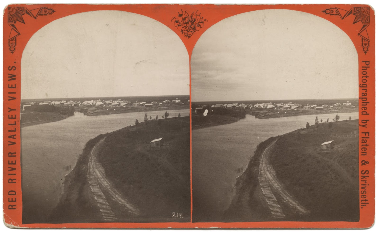
PHOTO INFO: A stereoview showing the railroad track along the eastern bank of the Red River in St. Vincent.This track is the continuation of the one coming in from the east into town from the "Y". This was laid down early on in anticipation of the main line going through town and over the river, but a rail bridge was never built.
Swan Anderson would get fan mail from people far and wide that had once lived in St. Vincent and the surrounding area, generated from his newspaper columns for the Enterprise, and even from his toll-free phone number into his home. Swan kept sharing history even when he was in the nursing home. And thank goodness he did.
Speaking of fan mail, let me share with you a letter Swan received from the LeMasuriers of Ontario, California; as many reading this may remember, the LeMasurier family lived in St. Vincent at one time. This letter shares some more history about St. Vincent and the railroads. Please note that the story told in the letter is second-hand, being told to the LeMasurier family by George (aka "Shorty") and Bessie Cowan. That does not make it any less true, but I wanted to be sure everyone knows the chain of how the story came to us.
Read on...
Before the turn of the century and when the railroad from Winnipeg east wasn't finished, St. Vincent was a booming railroad town. The round house was out by Lake Stellaand had a turntable to turn the engines around. The long depot in St. Vincent housed the Customs and Immigration offices. There was also a Signal House. In 1901 William LeMasurier bought itand moved it to his farm north of St. Vincent.He and his bride, the former Maggie Easter, started housekeeping there in 1902. The land north of St. Vincent and west of the Emerson road was all railroad land. Phillip LeMasurier bought some and later sold it to his sons, William and Arthur. John and George Cowan bought some, also Mose Parenteau and Austin Griffith. The railroad reserved a right-of-way along the top of the river bank. Bessie Cowan told me at one time the railroad had planned to build a bridge across the Red River on Shorty's land.
The land that the railroad bridge would have crossed into/from is located on this plat map in the northwest corner of Section 35, labeled George Cowan . . .
The Great Northern Hotel was a three-story building with a ballroom on the third floor. Bessie Cowan gave us a picture of it and we left it with the Pembina Museum when we left St. Vincent. When the hotel was torn down, the attached section that was the kitchen was bought by the Russells and made into their home. Later, Harold Easton bought it and finally Milton Gregoire bought it and tore it down, and built what is now known as the Nellie Blair house.
There was a strip of land from the Red River to the Emerson road, 137 acres in the Village of St. Vincent on its north side. Austin Griffith bought the 36 acres next to the Emerson road and Charlie LeMasurier bought the rest from Peter Monro. Harris remembers when Charlie had a lot cleared along the river. The man doing the work used oxen. Mrs. Morrow, who lived in St. Vincent, used to pick roots and would give Harris fifty cents to haul a load to town for her.
As I passed out through the crowd as it was dispersing on Sunday evening after the meeting at which Comrades Pettipiece and Fitzgerald were speaking on the Woman question, I chanced to hear a few remarks from some of the men that had been present at the meeting which struck me as rather amusing. One of the worthy bunch said in a rather sneering way: "What! Give the women a vote? Not much, their place is stay at home and minding their business, let us men do all the voting."
To me, of course, it was the same old yarn. I have heard it so often that I cannot keep silent any longer. Some of the men do not stop long enough to think just what a very important part a woman does fill in this life. If we women are fit to be mothers of their children; fit to teach those same children in the schools, and fit to fill most every position in life, then by all that's good and holy we are able to stand shoulder to shoulder with our noble brothers and cast our vote along with them for the one great cause for which we are both fighting, the only cause that will benefit the working men and women of today.
"Men say that we women do not have sense enough to vote the right way. Ditto, my brother! Could we possibly make it any worse than you have made it by your way of voting?"
Men say that we women do not have sense enough to vote the right way. Ditto, my brother! Could we possibly make it any worse than you have made it by your way of voting? Give the woman a chance. Let her once grasp the situation and see if she won't vote right. Treat her as an equal and try to help her get hold of a few socialistic ideals. Help her to see what it all means. Give her as fair a chance as you would give a man and you will find out that she can grasp the truth just as quick as any man.
I believe it is up to every woman in...any place on top of this old earth, to get busy, and dig down and find out for herself just where she is at and if some of the men turn up their noses at our feeble efforts, go to it with more heart than ever. Prove to them that if given a chance we can at least use our vote to as good advantage as they have in the past. We cannot make matters any worse than they are making them right now. So go to it, my sisters. Show them if we are fit to be mothers of the coming generation of Socialists we are fit to march to the ballot-box and vote the right way just as soon as you men give us a chance. And fit to share equally with you all the comforts that Socialism will bring when the men as well as the women get into their heads sense enough to vote the right way to hasten its coming.
[Source: Lena Mortimer, "One Woman's Way of Thinking," Western Clarion (Vancouver, BC), 27 May 1911.]
Wonderful news arrived in today's mail. The work here on this blog has been recognized and awarded the Excellence in Local History award by the State Historical Society of North Dakota.
It is an amazing honor to be chosen for this award. It is my hope that this award will bring further recognition to the amazing local history of my hometown, its neighbors, and the surrounding communities which are so interrelated. The individuals that make up these communities are related by blood, marriage, and culture, and their shared histories deserve not only to be recognized, but remembered...
VERY large scan of an 1878 stereograph of St. Vincent and Pembina, taken from Minnesota side of the Red River of the North.
Note the two railroad tracks merging into one, going along the the high bank of the Red River of the North. This is on what is the far west side of town, as the river curves north. There is no slope or erosion as there is now, let alone river woods all up and down the banks as we're used to, today. And take a close look at Pembina in the background - Click on the image to open, then click on it again to maximize it, to see as much detail as possible.
This is the earliest known photograph of our St. Vincent and Pembina that I am aware of. I am hoping to print this in the size of a stereograph and view it in one of my stereoscopes, in hopes that seeing it in 3-D might bring further clarity to the details...
The little border town of Emerson, Manitoba, was a surreal place to be in April 1997. Behind the permanent dike that had been doubled in height with the addition of a temporary structure of plywood and sandbags, Emerson was a dry island in the vast sea of the Red River, which had burst its banks. All the inhabitants, with the exception of a few who had been left behind to fight the flood, had been evacuated. The electric power still worked, so that at night the island of Emerson was ablaze in a strange white light. Deer and hares and other smaller animals had gravitated to the town to escape the ice cold waters of the raging river. They stood, frightened sentinels, in the white light of the ghost town.
A remarkable crew made up of town employees, a detachment of troops from the Canadian Forces and local Mounties kept the town of Emerson itself dry and secure. As the river rose to a critical level in late April, with no firm prediction on how high it would get, the struggle to maintain the wall around the town was in deadly earnest. Coordinated out of the Emerson Town Hall, the beleaguered warriors filled sandbags and directed them to potential weak points on the perimeter. So close is Emerson to the U.S. border, that a portion of the dike actually crossed into the small neighboring community of Noyes, Minnesota, protecting a U.S. Customs office and several nearby homes on U.S. soil. As residents noted at the time, what they were calling the "Red Sea" did not make distinctions between one side of the border and the other.
[The writer returns five years later, and talks to survivors in both Emerson and Pembina of their ordeal during the 1997 flood, then goes to the border to travel to Grand Forks to interview survivors there...]
In the large new Canada Customs post at the border- built since the flood of '97 - I meet two tall, muscular customs officers who have recollections of the mayhem...When asked about the purpose of my trip to North Dakota by a U.S. Customs official with grey hair, I tell him I am going to Grand Forks to talk to people on the fifth anniversary of the flood of '97. Not bothering to ask me for ID, he comments sardonically, "Why not go to Pembina? They know at least as much about the flood as anyone in Grand Forks."
I follow his advice and drive into the little town of Pembina, two minutes south of the border. The town had been British territory before it was handed over the U.S. with the adoption of the forty-ninth parallel as the border across the Prairies in 1818. On the east side of Pembina, there is a high earthen dike to protect the town from the Red River. It is the same on the other side of the river in the tiny hamlet of St. Vincent Minnesota. This April the Red is tame, but the dike is there for protection against future floods.
On the main street of Pembina, I find an old preacher and his young disciple out trying to win converts. I ask them if they were in town for the great flood of '97. In reply, the old man hands me a pocket-sized pamphlet titled, "A Preacher of the Old School." In our conversation, Mr. W. Seed and I are at cross-purposes. He is trying to save my soul from a flood of biblical proportions while I am in search of memories of a mere earthly flood. I manager to get Mr. Seed onto my line of inquiry, and he tells me of the long series of floods that have afflicted this community - in 1897, 1950, 1966, and 1979. In 1997, he says, the dike held and the town was saved.
In 1930, two brave young men paddled from Minneapolis to Hudson Bay and documented their odyssey in the book Canoeing With the Cree. For the 75th anniversary of this historic adventure, two men canoed the same route in 2005, followed by two other men in 2008. No women have ever successfully canoed this route.
I'm late to the game on reporting this one, folks, but as they say, better late than never.
Two women are attempting what has never been done before, and their path has went right through the heart of Pembina/St. Vincent on the Red River of the North.
Right now they're waiting on the weather - high wind advisories on Gull Harbour - so they're taking a forced break until things calm down.
While they have a dedicated website for this journey, I recommend you also check out their blog, where they keep everyone updated daily on the latest.
In eighteen hundred and fifty-nine, out on the great west plain The Prairie Schooner & ox cart, ruled the golden waves In old St. Paul a bounty was set, by the shaking of the traders’ hands To bring the mighty steamships to La Verendrye’s lands
Down on the Mississippi, Anson Northrup was heard to say “That eight thousand dollar bounty’s mine and my riverboat’s the way” We’ll launch at Crow Wing River and then go up the Red But first we’ll have to strip her down and take it north by sled
Chorus: The little girl playing on Fort Garry’s wall cried, “Sounds like someone blowing in a bottle” The great bells chimed at St. Boniface, as the Captain leaned on the throttle The children screamed, farmers ran to town, Metis feared the waking of the dead Their muskets roared and William Ross implored There’s a steamboat comin’, there’s a steamboat coming, The Anson Northrup’s comin’, comin’ ‘round the bend
The ragged ship set its compass north, followed the old Red River Trail And only three dared to get on board, so sure that it would fail As sparks roared from the smokestacks, rainin’ down on the dry cargo bins The furnace drew such a colossal draft, might take the fireman right in
The trip up the windy Red River was to take just four days But the bison still ruled the prairie and their crossing caused great delays “Well I bet my last bottle of whiskey, that boat must surely run aground” Said the rector at Fort Pembina as he heard its disappearing sound
As often happens in my research, I stumble across something when looking for something totally different. The poem below was written about the Red River; I smiled when I first read it, because it's obviously so idealized (at least about the river itself). There are also elements of imperialism and prejudice regarding the aboriginal cultures. Yet, to be fair, there are at the same time paradoxical phrases (such as "priestcraft's snare") that could be taken as condemnations of the eventual results.
by J.C.H.
'Neath high arched skies of clearest sheen, Sweeping thro' prairies' boundless green, Where branching elms and poplars throw Dark shadows of the flood below; Thro' the great rival nation's land, Uniting them with silver band, We greet thee, as we greet a Queen, Red River of the Northern Plain.
Thy crown is of the azure hue Of sun-set sky and pearly dew; Thy tresses of the ivy made, Twined with the willows, lighter shade; The Bois de Sioux, the small Marais, Unite to make thy girdle gay; The Assiniboine and wild Roseau Thy fair feet have in Northern Plain.
A Naiad Queen - thy bounteous hand Refreshes oft the parched land; The cattle bellow forth thy praise, The blackbirds land thee in their lays; The plover, mallard, and wild goose The slow-paced bear, the antlered moose, Come, lave and drink, a thankful band, Queen river of the Northern Plain.
Pray tell us of those ancient men, The Sioux, the Blackfeet, the Cheyenne, Whose forms majestic, by thy face Reflected were - a stately race; Their children on thy banks still stand, Sad remnant of a noble band; Their old renown, their fate, you ken, Old rover of the Northern Plain.
Then tell us of the men who came In humble guise and holy name, Who bore the cross, and taught that loss Was gain, and gain on earth was loss, With Him before whose sacred throne The red and white man count as one; Good men, ye sought for heaven to tame The wild men of the Northern Plain.
But ah, my Muse, in shame and tears, With downcast eyes, of after years She tells. By lust and lucre nurs'd, Came wrongs and cruel deeds, that curs'd The land, sod made the red man fall And fade, who had been king of all Canadians - shall the coming years Redeem from stain our Northern Plain?
Astraean Muse, the tears conceal, And of the coming years reveal; "Fair Queen, thy virgin shores shall be The home of Myriads blest and free; From despot's rod, from priestcraft's snare Thy waters pure their freight shall bear, Thy praise they'll raise, thy glory feel, Queen River of the Northern Plain."
NOTE: The Bois de Sioux, Marais, Roseau, and Assiniboine are four of the many rivers that drain the northern part of this immense prairie, and fall into the Red River of the North...
It's fascinating to read this article that includes information on the Red River ferry that once connected St. Vincent and Pembina. The method Davies alludes to in the article, must have been a rudder (possibly used in conjunction with a tiller control) that was pushed along by the current, and the ropes were just used to guide it in the desired direction, instead of using a more common pulley system...
Heading to the St. Vincent side of the Red River...
William H. Moorhead was a colorful character that was involved in many events of local historical significance. I have written about him before, as well as shared a story written about our area that featured him in it. In the course of my research, his name has come up over and over again in accounts of history relating to my hometown area.
The above article was reprinted many years ago, showing photographs featuring "Highwater Bill" in them, during the 1893 flood. Click on it to see an enlarged version, easier to read...


 [Note from Trish: I later spoke with DeeDee and got some very interesting information from her! Also, the pump in the photo at left, was found by her, and then taken and donated to the Kittson County History Center & Museum, where it is today, along with the Anchor found many years ago by Humboldt's Bockwitz family...]


.jpg)