Showing posts with label boundary. Show all posts

Monday, February 20, 2023

The Last of the Fenian Raids


Before Pembina, there was Vermont...

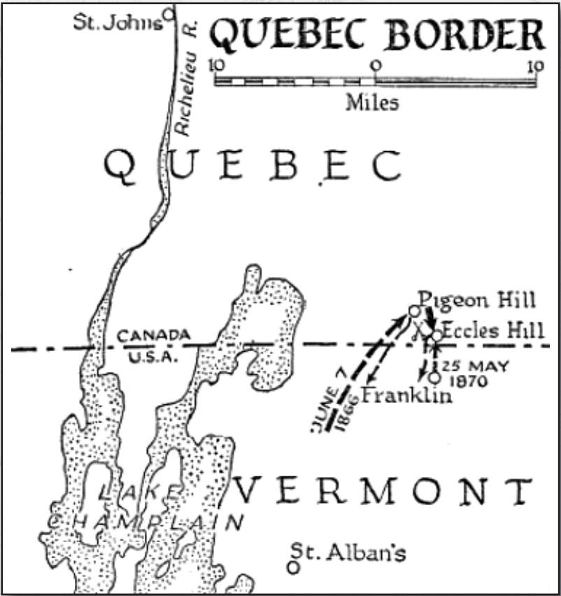
Soon after joining up in 1870, Private William James Kneeshaw, along with his brother, Sergeant Ebenezer Muir Kneeshaw, saw action during a Fenian raid on the Quebec/Vermont border.  Their unit - the 11th Battalion's Argenteuil Rangers - defeated the Fenian's attempt at invasion of Canada, once again; it was another of an ongoing string of incursions along the 45th parallel beginning in 1866.
 
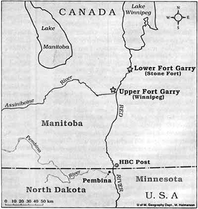
In 1871 John O'Neill and an odd character named W. B. O’Donoghue asked the Savage Wing Council to undertake another invasion of Canada across the Dakota Territory border. The Council, weary of Canadian adventures in general and O’Neill in particular, would have none of it. O'Neill's idea was turned down, but the Council promised to loan him arms and agreed they would not publicly denounce him and his raid. O'Neill resigned from the Fenians to lead the invasion, which was planned in Saint Paul, Minnesota, to invade Manitoba near Winnipeg. About 35 men, led by John O'Neill, William B. O'Donoghue, and John J. Donnelly, hoped to join forces with Louis Riel's Métis. 

On October 5, O'Neill's force managed to capture a Hudson's Bay Company post and a Canadian customs house which they believed to be just north of the international border. A U.S. survey team had determined the border was two miles further north, placing the Hudson's Bay post and the customs house both inside U.S. territory. O'Neill, J. J. Donnelly and ten others were taken prisoner near Pembina, Dakota Territory by U.S. soldiers led by  Captain Lloyd Wheaton.


The farcical raid was doomed from the very start. It actually took place inside the United States, and the Métis under Riel had signed a pact with the British just as the invasion began. Riel and his Métis captured O'Donoghue and gave him to U.S. authorities. In a somewhat muddled federal response, O'Neill was arrested twice - once in Dakota and once in Minnesota - but was released and never charged for "invading" U.S. territory. The men captured with him were released by the court as simply "dupes" of O'Neill and Donnelly.  It was John O'Neill's last hurrah.

And what happened to Vermont's W.J. and E.M. Kneeshaw?  Well, W.J. ironically emigrated to Pembina in 1873, not long after his militia service expired.  He became a lawyer, and eventually the well-known judge,
Judge William J. Kneeshaw.  His older brother E.M. (or as Ebenezer preferred to be called, Muir) eventually followed him to Pembina in 1880, initially farming for a bit, later becoming a surveyor. 

On a medal that Muir received:  On one side it has Victoria Regina et Imperatrix meaning, "Victoria, Queen and Empress", along with her raised image in profile.  On the other side it has a raised image of the Canadian flag (1870 version), with the Union Jack and Canadian coat of arms, with some greenery.  Around the edge of the coin, is stamped the rank and name of Sergeant E. M. Kneeshaw, as seen below.  On a bar, across the base of the ribbon, is stamped, Fenian Raid 1870...


Wednesday, May 23, 2018

Guest Essay: The Story of West Lynn

West Lynne, Manitoba townsite, today.

The Story of West Lynne and the First Customs House in Western Canada 
by James McClelland

To  say that the oldest federal building in southern Manitoba had a diverse and chequered past would be an understatement. According to the old Winnipeg Telegram, this building was originally built in the 1850s. The design and architecture were similar to buildings found in the Acadian region of Canada. The article describes the building as "20x26, and made from hewn oak timbers, dove tailed at the corners." Later this building would serve as a symbol of Canadian sovereignty and a floodgate against Yankee commerce.

Today it sits just 500m north of the border it guarded for so long.
The line separating the United States from British territory had always been vague and tentative. Agreement that the 49th parallel would record the western boundary was established as early as 1818, but its exact location tended to shift each time a party had been sent out to survey it. Between 1823 and 1870 three different boundary lines had been drawn; all of them controversial.
In the 1840s, agitation began to develop along this line between the free traders from the Red River Settlement and the Hudson Bay Company officials at Fort Garry. In 1843, the first regular cart service between Pembina and St. Paul was opened. This provided easy access to the American markets. This bickering heightened as more Red River traders sought the higher American prices. It intensified in 1845 when Norman Kittson, an American Trader, opened a store just a scant 4km south of British Territory, at the junction of the Red and the Pembina Rivers.

The door of American commerce was beckoning. In fact, Kittson offered such good prices for fur that the ensuing rush of illegal trade from British Territory was referred to by the HBC as "Kittson’s Fever". As a counter-move in September of 1845, the Hudson Bay Company opened a post called North Fort Pembina. It was located on what they considered their side of the line. The Company put John Palmer Bourke, a retired officer living in the colony, in charge of this new frontier post.

During the winter of 1845-46, Robert Clouston, an employee from the Stone Fort visited this place. In his journal, he described these Spartan surroundings.
"Mr. Bourke has a rough log house, the walls of which, inside and outside are plastered with clay, and the roof covered with earth - it is floored with rough logs: the men live in the same house, with merely a partition between them - a mud chimney in each room and a door opening from Mr. B's apartment to his trading room"
The following day Clouston visited Kittson's store. The uncertainty of the exact spot where American and British authority met is noted in his diary:
"About quarter of a mile above the house (the HBC store) we saw a post planted by Major Long - marking the boundary at a place called Monroe’s Encampment some wag had pulled up the post of demarcation and placed Uncle Sam's initials toward British territory." 
Clouston later reported that Kittson's store was about 3 kms farther south. Here, between Kittson's store and the HBC post, the log house was originally located.

From these squalid beginnings the HBC post at the border continued to develop. A sketch from 1858, shows several log buildings surrounded by a sturdy log palisade.

However, the strip of land between North Pembina and Kittson’s store quickly developed into a "no-man's land." Other buildings sprang up and an unsavory frontier community known as Huron City was born. A few years later the Lieutenant-Governor of Manitoba would complain to Ottawa about the rowdy brawling atmosphere and the flourishing trade in whiskey smuggling that was going on in this "Whisky Post". By this time, the log building, had been turned into an inn.

Unquestionably, many travelers passed through the doors of this establishment, but two guests in particular played a very important role in the creation of Manitoba. In the autumn of 1869, the Hon. Wm. McDougall, the Governor designate of Rupert's Land, stayed here briefly after he was denied entry into the Red River Settlement by Louis Riel's metis guards. In December, McDougall would return to the deserted post and read a Proclamation declaring himself the official lieutenant-governor of the region. Ironically, in August of the following year, Louis Riel himself found momentary refuge in the same building after his hasty escape from Fort Garry.


On July 1, 1871, F. T. Bradley arrived to become Collector of Customs. The log building, empty at the time, became Manitoba's first regular Customs House. It also served as a telegraph, express and postal office. Yet, in October 1871, one of the most bizarre events in Canadian history had yet to unfold on these premises.

Thursday, March 16, 2017

Frederick A. Bailey: An NWMP 'Original'

Sgt. Fred Bailey
[Source:  RCMP Veterans Association,
Vancouver Division]

Let me introduce you to an ordinary man who happened to make a bit of local history by just doing what many in his day did - living life, making choices, taking risks.  

"This I believe is the diary of Frederick Bagley when he enlisted in the North-West Mounted Police as a trumpeteer at 15 years of age; They left Fort Dufferin in 1874 to secure the Medicine Line!" 
- J. Rempel

I will be sharing portions of that diary here on this blog at a later time. But for now, let us learn a bit about Sub-Constable Fred Bagley, Trumpeteer ...


According to a fascinating online biography (which I quote here in-full since so many such pages seem to disappear):
Fred Bagley’s musical talents and leadership provided a major contribution to the Force and to the communities he served in.

With regarding setting records, he was first in the following areas: 
a) being the youngest member to be sworn into the Force; 
b) first Trumpeteer in the Force; 
c) present to guard and witness the first person to be hung in the North-West Territories at Fort Saskatchewan; and 
d) first member to lead a musical performance before Royalty.

Tuesday, June 28, 2016

Boundary Markers: "Soup Plates"

In the September of 1872, some two-hundred and fifty astronomers, blacksmiths, cooks, engineers, medics for the work animals and the working humans, naturalists, surveyors, topographers, wheelwrights, and woodworkers, gathered at the small isolated town of Pembina two degrees south of the parallel. When their American counterparts, flanked by the United States cavalry, arrived, the five-hundred members of the North American Boundary Commission were united in common cause. - From Beneath My Feet
George Mercer Dawson
A few months back, a friend of Jake Rempel - who is also a friend (and a fellow local historian) of this blog's writer - found a dish in an old basement north of Fort Dufferin near modern day Emerson, Manitoba.

How it got there is not known. Oral history has it that the building that used to be upon the foundation, was once a bar and a house of pleasure.

Boundary Marker Plate

Jake said, "I know they used different types of steel markers; I am not sure what they used right in the beginning, pole markers of some kind. George Mercer Dawson followed the survey crew and seems to have placed soup plates as each marker. This reference (below) in his book, Beneath My Feet, is all I have found about this type of marker..."


From George Mercer Dawson's Beneath My Feet
There is still an International Boundary Commission to this day. They describe their ongoing mission "...as maintaining the boundary in an effective state of demarcation. This is done by inspecting it regularly; repairing, relocating or rebuilding damaged monuments or buoys; keeping the vista cleared, and erecting new boundary markers at such locations as new road crossings."

Monday, June 06, 2011

Customs Stories IV: F.T. Bradley

One of the clearest copies of this photo that I've ever seen!
F.T. Bradley

In 1871, a customs house was opened on the west side of the Red River, and the first Collector of Customs, F. T. Bradley, (seen in above photo) was appointed. Bradley became an important figure in Emerson’s early years, becoming also a director of the Emerson and Northwestern Railroad and organizing the first Masonic Lodge of which he was Grand Master. By 1872, the customs building also served as a telegraph, express, and post office for what was known then as North Pembina and came later to be known as West Lynne. It was later discovered that this “Canadian” customs building was actually sitting on the American side of the boundary—and was hastily dragged north! The customs house, the first in Western Canada, is now located on the north side of Highway 75 on the west side of the river, along with Emerson’s first jail, also a well-preserved log building.

Source: Manitoba Historical Society, Tour of Emerson

This burial site on a small piece of property owned by the Town of Emerson (now part of the Municipality of Emerson-Franklin) is a considerable distance from the road, in the middle of a farm field. It contains the 1885 grave of Emerson customs official F. T. Bradley along with the ones of his wife Caroline, who died in 1879, and four of their sons. The wife and children had originally been buried in the Old Anglican Cemetery but were moved here in 1900. A single white monument for Caroline Bradley and their four sons is located in the centre of a 16-foot by 22-foot rectangular area delimited by a low concrete wall. A small concrete marker with Bradley’s name and the Masonic symbol is also located inside the rectangle, as is a small white stone marker bearing the initials C B.
In February 1884, Bradley was arrested on a charge of fraud and embezzlement of over $4,000, relating to a shipment of coal by the Canadian Pacific Railway, and was transported to Winnipeg for trial. He soon became too ill to appear in court, and died on 27 February 1884 without regaining consciousness at the Winnipeg home of his brother-in-law and physician Alfred Codd. His body was returned to Emerson for burial, but not in the local cemetery, instead in a 20- by 20-foot plot northeast of town.

Friday, June 03, 2011

Port-of-Entry: Emerson 1947

An image I found online for sale, of the Emerson port-of-entry, circa 1947
Locals would be waved through without stopping back then.  Even when I was growing up, they still did.

It's a different world now.  Technology has given and it hath taken away.  It has provided ways for very bad people to potentially do even worse things to innocent others.  In return it has given us countermeasures to fight against those ways.  In the meantime, we become prisoners of supposed safety...and there is less open and easy opportunities for neighborliness - at least of the frequent, in-person variety that deep and lasting bonds are made of.

Saturday, May 28, 2011

Setting the Record Straight

This appeared on the editorial pages of the Winnipeg Free Press recently...
In your editorial Radicals always in our midst (March 16), I was surprised to read in your editorial that in 1871 "the Irish rebel John J. O'Neill met Métis leaders in Manitoba to enlist support for an invasion of Canada in an effort to weaken British oppression in Ireland." I would respond: what Métis leaders?
I have researched this issue extensively. William O'Donoghue had recruited four Fenian leaders to come to Manitoba. The Fenian Brotherhood did not officially sanction this trip, but provided funds for 300 muskets. They had about 30 men with them when they crossed the Manitoba border and ransacked the HBC post at Emerson, which was called "Fort Pembina."

Wednesday, April 13, 2011

Geographic Trivia

From early on our area was unique,  geographically & politically
[Click to enlarge]
It is often thought that the title was secured by the U.S. at no cost. However, the territory of the original Louisiana Purchase west of the Red River Valley does extend north of the 49th parallel.

Annexed by Britain in exchange for its cession of the Red River Valley, the northernmost parts of the Louisiana Purchase are the only North American territory ever ceded by the United States to a foreign power.

The region was sparsely populated until Ojibwe claims to the most fertile portions of the valley were extinguished in the Treaty of Old Crossing (1863), after which it opened rapidly to agricultural development and settlement in the 1870s and 1880s. The area is one of several distinct regions of Minnesota.

From Red River Valley

Monday, November 22, 2010

NWMP Arrive in Fort Dufferin

North West Mounted Police trooper from 1870s
[Artist:  R.J. Marrion - Canadian War Museum]

Fort Dufferin was originally established in 1873 by the North West Mounted Police (later the Royal Canadian Mounted Police) - this site was also used by the International Boundary Commission in its mapping of the International Boundary in 1874.

That same year, men were recruited for important efforts even further west, but to get them there, they had to come down into the United States, then back up into Canada (direct travel not yet being practical due to obstacles such as the Canadian Shield...)  The article below chronicles their adventures 'getting there', coming through Fargo, then Fort Dufferin (the modern day Emerson area...)

[A thank you to Jake Rempel of Halbstadt, Manitoba...]

Saturday, April 24, 2010

Ephemera: Promotion of Progress


The image above is from an envelope I have in my possession. It is in the upper left-hand corner representing the return address of Charles Johnson of Pembina. I haven't been able to find out much about Mr. Johnson, but do see him listed in the Pembina County Pioneer Daughters Collection of the Elwyn B. Robinson Department of Special Collections, Chester Fritz Library, at UND.

To me, it shows the ambition of not only Mr. Johnson, but the dreams of the communities he represents themselves. At the time of the late 19th/early 20th century, things were changing fast, and hopes were high...

Wednesday, April 21, 2010

Huron City

Huron City - Location: 485950N by 0971400W - was a real place that no longer exists. I grew up just a stone's throw geographically-speaking from where it once stood and never knew. I discovered this place (and a few others) through my research for this blog, stumbling upon it quite by chance. It appears to have been the 'twin city' to Noyes, as Pembina is to St. Vincent, it being on the Dakota side of the Red River. The more I find out about my hometown area, the more I realize that much more land than I had any idea of, was at one time populated as camp, fort, mission, or town, then later went back to what eventually became farmland...
Heading north out of town, they approached Huron City at the International Boundary. In spite of land speculators' wild claims as to the town's grand future, only a few cabins and a small hotel were in existence. Charley knew that the hotel held the reputation of being the local brothel. Crossing the boundary line, they came to the road between West Lynne and Emerson. The hot, humid afternoon seemed to wrap the two men closely. - From BORDER TOWNS (Chapter 14), by Charles Harris Walker

Monday, March 15, 2010

Terratorial Aquisition: 1818

The treaty marked the last permanent major territorial loss of Continental United States, the northern most tip of the territory of Louisiana above the 49th parallel north, known as the Milk River in present day southern Alberta. Britain ceded all of Rupert's Land south of the 49th parallel and west to the Rocky Mountains, including the Red River Colony [of which our area was considered part of, at that time - Trish Lewis]

From Treaty of 1818

Monday, September 07, 2009

Early Boundary Marker

Marker at the International Boundary and principal meridian, Pembina area, Manitoba. In background Cree medicine man with pipe leads procession to willow enclose for a dog dance ritual. Cree camp at right. Midewiwin ritual.

Sketch by Major G. Seton (of the Royal Canadian Rifles)

Friday, July 31, 2009

The Trial of Pierre-Guillaume Sayer

To the cry of "La commerce est libre" from the armed Metis stationed outside the courtroom, the monopoly of the Hudson's Bay Company in Rupert's Land was effectively broken... - from The Road to the Rapids
Who was Pierre Guillaume Sayer, and what did he have to do with our area? And not only that, why did he have an important role in the history of our area?
Sayer’s significance derives from his trial in the General Quarterly Court of Assiniboia on 17 May 1849. The free trade in furs, practiced in the Red River valley since 1821, had greatly increased with the opportunity from 1843 to sell at Pembina (N.Dak.) to Norman Wolfred Kittson, who was in direct competition with the Hudson’s Bay Company. Sayer was arrested for illegally trading in furs, and was brought before the court by Chief Factor John Ballenden in a case designed to test the legality of the monopoly claimed by the HBC. Sayer’s counsel was James Sinclair, a representative of the free traders of Red River; the two were backed by Louis Riel Sr, who, with the Reverend George-Antoine Bellecourt, had organized the Métis to protest against both the monopoly and the inadequate representation of the Métis on the Council of Assiniboia. Presided over by the judicial recorder, Adam Thom, the trial was by jury and was conducted fairly. Sayer admitted to trafficking in furs, but claimed that he had been exchanging presents with relatives, an Indian manner of trading.

The jury returned a verdict of guilty but recommended mercy on the ground that Sayer had genuinely believed that the Métis were permitted to trade freely. Ballenden accepted the recommendation and Sayer was freed. Riel promptly asserted that the verdict was tantamount to a surrender of the HBC monopoly. This view was at once taken up by the Métis assembled outside the court-house, who cried “Le commerce est libre!” So it was to be: the HBC abandoned its efforts to maintain a monopoly and began aggressive competition with the free traders. Sayer’s trial was thus a landmark in the history of the Canadian west.
From the Dictionary of Canadian Biography

Monday, May 18, 2009

Border Security: RFID

These readers on the southern border, shown in use here, will soon be installed at the Pembina border crossing...
A recent Associated Press article states:

PEMBINA, N.D. — New technology is being installed at the U.S.-Canada border crossing at Pembina, in northeastern North Dakota.

Radio frequency identification readers are being installed in all vehicle inspection lanes.

The technology can read chip-enabled travel documents, promising shorter waits for travelers who have them.

The technology is being installed at 39 ports of entry along the Canada and Mexico borders

More details: RFID Technology Installation to Begin in Pembina, North Dakota

Saturday, May 16, 2009

Les Eddington: An Autobiography

William Henneberry (left) and Lester Eddington Here is a photo of William Henneberry (left) and Lester Eddington standing by Henneberry's bullet-riddled Paige after the encounter with the Winnipeg bank robbers (August, 1928) - Hey, Chicago wasn't the only place with some serious Action!

One thing leads to another...I'm getting contacted by more old-timer Customs Agents, and wow do they have stories to tell!
Customs Trivia: Did you know that for nearly 125 years, from the formation of our country - prior to personal income tax implementation - that Customs funded virtually the entire government, and paid for the nation's early growth and infrastructure?
Jim Benjaminson (see below) is trying to get permission from the family of one of those men, to allow us to share more of Les' story here. For now, below is what Jim can tell us, just to whet your appetite...
Lester Eddington had a welding shop in Neche and joined the Customs & Border Patrol in 1925, serving until 1956. There were several employment changes as various government agencies took control, so Les was in most of them. When he retired, one of his supervisors told him he should write a book about his adventures. Which he did...it was never published and I have one of the few copies not in the hands of the family. The original text was 116 pages of typewritten, legal-size paper, single spaced!

When I was a kid growing up, he'd always tell stories and then relate that the story was in his book. He would then proceed to pull out the manuscript, find the page the story was on and that would be the only part of the book he would allow me to read. In later years, Garnett (Les' son) spirited the manuscript to me so I could read all of it.

About 20 years ago or so, I asked Lester to allow me to reprint one of his stories for the North Dakota Peace Officer magazine. I took the manuscript and transcribed it onto computer disc (a VERY early Mac system). I also did research about the story to provide a prologue and epilogue to the story. When he saw the story in print he asked me to put it all on computer disc.

As I stated, it has never been published. Its working title is My Experiences While In The Government Service. The only hand-written part of the book was the last page - in which Lester dedicated it to three people - Judson LaMoure (his boss), to Dave Elves (who he worked with at Sarles) and "...last but not least, the late Art Gould, Winnipeg, Manitoba, the greatest liquor runner that ever crossed the International Boundary in this District."

The story I wrote about (using Les' main text as the body) for North Dakota Peace Officer related the story of a robbery that took place in Winnipeg in August of 1928. A bank messenger was held up on the street near one of the banks--the bandits made their escape back towards the USA. They crossed the border in the Mowbray/Maida area with Les and William Henneberry in hot pursuit. Somewhere between Langdon and Lakota the bad guys made a stand and shot up the pursuing car (an unmarked vehicle). Lester was driving...one slug came through the windshield, hit the steering wheel and struck Les in the stomach. It wasn't a serious injury. The only thing that saved their lives that day was the bad guys saw the badge on Lester's belt - saw he was a federal officer and backed off. Long story short - the bad guys were never found. And Lester had the slug mounted as a watch fob!

Winnipeg 1928 - from http://iectomorph.blogspot.com/2007/06/winnipeg-1928.htmlI have extra copies of the ND Peace Officer magazine with that story, if you'd like me to mail you a copy. I also have photos of the shot up car with Lester and Henneberry standing beside it.

As for the text of the book, I'll have to get permission from the family. Like I say, I think I have the only non-family member copy in existence. I can't release it without getting their o.k. The book also relates many adventures, many in the Sarles, Hannah, Maida, Mowbray1 area as that was Lester's first post. He spent the last years of his career at Pembina.

PS - I glanced at your blog. And I know Chuck Walker.


Back in 1976 I did research for a booklet for the Pembina County Sheriffs Office, documenting all of the county sheriffs from 1867 to the present (Glenn Wells was sheriff then - he was later my boss when I worked for Pembina County SO 1977-1979). I took it upon myself to try and find photos of all the sheriffs at which I was mostly successful....I think I missed 5, Charley Brown being one of them. I also missed one sheriff for the list (William Truemner) that I discovered while doing other research many years later.


I do have a file called "Murder and Mayhem in Pembina County" and I probably have references to various incidents that occurred in the early Pembina/St. Vincent days. I have details on the Pembina post office shooting (that was also in ND Peace Officer)......Charlie and I have discussed this at times in the past, regarding the outlaw that was killed...


Just glancing at the blog I'm wondering how much of the story/dialog Charlie made up regarding Charley Brown???
Jim also wrote an article from which this is taken:
Police cars, like police work, have changed considerably over the years. Few of the early-day police cars were given insignias identifying their purpose. An early-day North Dakota federal officer, Lester Eddington, wrote in his autobiography, "...we did not wear uniforms, just carried Customs caps to use while stopping cars." Because of this, stopping cars was not easy; many times the officer would pull alongside the offending vehicle and display his badge to tell the driver to pull over. Even more dangerous was the practice of stepping out into the lane of traffic to hold one's hand in the air, ordering the offender to stop.
Clarence Bingham told me this about Les:
Yes, I knew and worked with Lester Eddington for a year or more during 1951 - 52. I did not know that Les wrote an autobiography, but it doesn't surprise me. His wife's name was Milicent. Their daughter (June) married Allen Henneman from Pembina.

Lester and his partner were in a chase and shoot out with a car load of bank robbers out in the Maida - Hannah area of the border during the early 1930s. Les had a bullet on his watch chain that he claimed came through the front of their patrol car and lodged between his long underwear and his stomach. He thought for sure he had been shot, because the slug was burning him...He lived and farmed near [Cavalier] after retiring from Customs.
1 - I Remember When...the Birth and Death of a Prairie Town, By John J. Elias

There are several factors that caused towns to spring up, grow and thrive for a number of years, only to fall into decay and finally disappear completely. At times some group of interested people took the pains to erect some memorial to remind the passerby that a town once existed there. Why it came into existence in the first place depended on physical features but most prairie towns were planted because the railways deliberately placed them there by building a station on the location. The railways spaced them about eight miles apart since that was roughly the distance a settler would travel from home to town and back in a day with a load of grain or just to go shopping.

Nelsonville was the big town before the coming of the railway, situated about ten miles northwest of Morden. It had the land titles office, a NWMP detachment, gristmill, stores, church and community hall. It was certain the CPR would pass through it.

Mountain City, south of Morden, also was a thriving village. It too had high hopes that it would be selected by the railway. Nevertheless, the railway always kept secret where it would go and located towns where it suited and benefited the railway most. The track was laid between the two towns and Morden received a station. In two years, both Nelsonville and Mountain City disappeared. Only a stone now reminds us of the existence of a previous thriving community.

The histories of many prairie towns are very similar; only the names are different. For this reason I’ll take the town of Mowbray as an example since I became acquainted with it when it still was a healthy hamlet. Provincial Road 201 passes through it. Since it is the only east-west road between the Pembina River and the Canadian-U.S. border we traveled through there many times since 1941, the year I started farming together with my wife, Esther.

Since we became acquainted with Archie and Lily Scott, we learned much about the early history of the area and the town. They presented us with a small booklet that gives a short history of the first settlers. There is no point in giving a lot of names since they are all unknown to anyone but those who have long passed away. It is enough to record that the first settlers arrived in 1880.

The Andrew Johnstones settled where the Scotts now lived. A crude log cabin not far from the Scotts was their first home. Archie took us to the building one day. The west end of the house was the first post office and served as such for over 20 years. When Andrew died, Mrs. Johnstone continued the service till Mowbray was formed.

As more and more families settled in the district, the time came when a school was needed. The school was northeast of the present Scott home. This was the school that Archie and Lily attended. Most teachers taught for only one year. By the end of the year some promising young bachelor had won the heart of the young lady teacher and soon they added to the school population.

As the district filled up, the CPR extended the railway from Snowflake to Windygates. In 1904 they erected a station and Mowbray came into being. Elevators, a store, lumber yard, blacksmith shop and hotel soon followed. The two-story school was built, but only the first floor was used for classes. The upper story was used as a community hall and for church services. Some homes were built.

Just across the boundary the town of Mowbray, North Dakota sprang up and flourished. The two towns in actuality functioned as one town. The Americans sent their children to school in Canada. The biggest customers of the Canadian hotel bar were Americans. The Canadians shopped freely in both Mowbray, Manitoba and Mowbray, North Dakota. The Americans also made good use of the railway.

Some time in the late 1950s the town was almost gone; only the station was left. One day a car parked in front of the station. To satisfy our curiosity we stopped and visited the couple that was sitting outside on the platform. Some children were amusing themselves in the back. The couple was very hospitable and readily acquainted us with the history of the station.

The gentleman, Percy Williams, was the present owner of the station. His parents had arrived in Mowbray in 1927. His father passed away when Percy was a young lad and his mother carried on as the agent as long as the train service continued. In the beginning Mowbray had three passenger trains a day and this was cut down to one train a week. Service ended in 1954 and the mother and Percy left the district. Percy was able to buy the station from the CPR for a nominal price and he kept it in repair. He had already planted trees and shrubs around the property and the family spent the summer weekends there. They claimed they enjoyed driving to Maida for supper and visiting the farmers that were left.

The time came when we no longer found them there. Last summer (2008) a friend and I passed by and noticed a car parked in front of the station. I visited with the couple sitting outside and was told that Percy had died and had sold the station eight years ago. The trees and shrubs were now full grown and the lawns were freshly cut, but I noticed that half the platform had collapsed and the building too showed signs of considerable weathering. Still, it was good to see that the old station was still serving a purpose and had not been abandoned to slow decay.

What then was the main reason for the disappearance of so many prairie towns? The reason may be summed up in one word – transportation. It was the railway that built the towns. When there were no roads or few at best, the passenger trains with the mail car, flourished. When the automobile came along, roads were required. The first road to Winkler had no ditches and the roadbed was lower than the sides. As roads and cars improved, more and more people used the car to go to town, and the passenger trains were empty. Buses replaced the passenger trains and without passenger trains, the railroads were losing money. As a result they discontinued passenger service. In Mowbray the station was closed in 1954. The rails were salvaged and soon Mowbray disappeared.

As roads were improved and main highways paved, cars and trucks took over transportation. More and more branch lines were abandoned and now there is no elevator anymore between Winkler and Killarney. A large stretch has already been dismantled. The track serving Miami has been taken up. As time goes on more and more towns will disappear completely. -FROM Winkler Times article
I Remember When...The Birth and Death of a Prairie Town

Monday, May 04, 2009

Officially American

Major Stephen H. Long of the United States Army was the most important government-sponsored explorer in the decade after the War of 1812. He led three major and several minor expeditions up the Mississippi, Missouri, and Arkansas rivers and the Red River of the North, as well as exploring the central and southern Plains, the Front Range of the Rocky Mountains, and the Great Lakes. His companions included engineers, cartographers, naturalists, ethnologists, and artists, and they gathered a wealth of scientific, military, and artistic data about the interior of North America. For years Long's expeditions have been overlooked or misunderstood; here for the first time they are placed in the context of American scientific development.
When they reached Pembina on the Red River, the explorers paused. There, they had only one task - to decide whether the village lay north or south of the 49th parallel. Once they had done that they would begin their journey back to the eastern states. The return trip would take them along the virtually uninhabited north shore of Lake Superior and then south across the Great Lakes, a region that offered them little scientific challenge. In fact, rather than examining animals and plants along their route of march, the naturalists found their chief task to be getting themselves and their equipment back to civilization before the early northern winter blocked travel. This they succeeded in doing. yet, they encountered so little of interest or significance that the last half of the expedition proved anti-climactic for them.

On August 5, 1823, the explorers rode into Pembina and found the settlement virtually deserted. Most of the villagers had left on their annual buffalo hunt nearly seven weeks earlier and had not yet returned. The next day, the hideous screeching of 115 wooden carts loaded with fresh buffalo meat announced the villagers' return as 300 men, women, and children marched into town, shouting and singing. They had good reason for joy. Each of the wagons carried some 800 pounds of buffalo meat, enough to last for the winter. For a community with almost no domesticated animals, the annual hunt was a matter of grim necessity and this had been a good hunt.

The happy townsfolk straggled into their rude community, which consisted of about sixty log cabins strung out along the banks of the river for nearly five miles. A Hudson's Bay Company trading post had operated there until earlier that same summer, when company officials guessed that the settlement lay within the United States. Now the building stood empty. By August 8, Long and Colhoun completed their survey and astronomical observations and decided that the village did indeed lie south of the 29th parallel. Accordingly, on that day the major had an oak post placed in the ground at the border. On the south side of the pole he put the letters U.S., while G.B. faced to the north. At noon the troops raised the American flag and fired a salute. Then, in the presence of the villagers, Long proclaimed that "by virtue of the authority vested in him by the President...the country situated upon the Red River, above that point...was within the territory of the United States."

This simple ceremony completed the explorers' last specific assignment, and all that remained was their return trip. Long's orders called for the detachment to follow the 29th parallel east, but the settlers urged him not to try that route. They described the entire region between the Red River and Lake Superior as a maze of marshes, small lakes, and boulder-filled streams - all virtually impenetrable by a party as large as Long's. Instead, they claimed that the only practical way to travel east was by canoe via the larger streams. This advice convinced the Major to use his discretion, as Secretary of War Calhoun had suggested, and he chose to proceed north into Canada before turning east. Accordingly, the party prepared for the last part of their journey.

The brief stay at Pembina precipitated several bitter quarrels within the detachment, and, as a result, Mr. Beltrami quit the expedition. Long noted that the mercurial Italian, "having taken offense at the party generally, and being highly provoked at my objecting to his turning an Indian out of our lodge, left the party in a very hasty and angry manner." The Italian had proved a troublesome companion, and few of the other explorers expressed any regret when he left. James Colhoun claimed that the Indians said that one of the explorers "must be a foreigner, because he wanted the mild expression of countenance, which they said is universal with Americans. Their judgment was correct," he concluded. When the argument ended, Beltrami bought a horse from Long, and with a single companion rode south to find the source of the Mississippi. They failed to do so, but did find and name Lake Julia.

- From Stephen Long and American Frontier Exploration (1995)

Wednesday, March 04, 2009

Profile: H.L. Hime, Expedition Photographer

Encampment on the Red River - Hind Expedition, 1857
Born in Ireland, H. L. Hime came to Canada in 1854 and joined the Hind Expedition as official photographer. His photographs are probably the first ever taken of the Canadian prairies.

As so often happens, due to the geographic proximity, he is connected to our area in that he passed through it, and made observations of the land and the people living here...


The Palliser and Hind Expeditions, 1857 -1860

By 1855, the last remaining piece of wild land in Canada West (formerly Upper Canada) was sold for settlement. This allowed politicians to look to the prairies as a possible region to open up for immigrants. Starting in 1857, two explorers named John Palliser and Henry Youle Hind would set out on a "scientific expedition" to discover if this land was suitable for mass settlement.

However, Palliser's expedition had another purpose. It was to survey the 49th parallel as a possible western border between the U.S. and Canada. This was crucial as America created massive east-west Intercolonial railways during the 1860s, a move that some in British North America viewed as an attempt by the Americans to expand their territory into what was to become Canada.


- From Intercolonial Railway, The Canadian Encyclopedia

On Wednesday we reached Fort Pembina, and stayed the night with Mr. Mackenzie, the officer in charge of the Post, whose sad fate last December (described further on) is a melancholy proof of the danger attending traveling alone during the winters of this climate. The woods and prairies are then perfect deserts, Indians being at their winter quarters, birds far in the sunny south, and wild animals hibernating, or seeking food and shelter in the thickest parts of the swamps and forests. So complete is this desolation in the interior of many parts of Rupert's Land during the winter, that Mr. Christie, chief factor of the Hudson's Bay Company, when traveling from Athabasca to Red River in December 1859, did not meet with a single Indian throughout a long and dreary journey of 1400 miles. (of that I can believe!!)

The thermometer at Pembina Fort indicated 22 below zero on the morning of December 2nd, when we left the Post. Having procured another train of two dogs at the small village of Pembina, two miles from the Hudson's Bay Post of that name, we struck across the prairie to the "first of the Two Creeks," where we camped...

Pine River crossing is the spot from which Mr. Mackenzie, who had so hospitably treated us at Fort Pembina, started on the morning of the 29th December 1859, on his ill-fated journey in search of assistance. He and some companions were escorting an engineer from Georgetown to Fort Garry, who was traveling thither to make alterations and repairs in the steamer Anson Northrup, then laid up for the winter near the Indian settlement. The party fell short of provisions, and Mr. Mackenzie pushed on in the hope of being able to send supplies from Pembina. After leaving his companions, he appears to have followed the trail for some distance, and at the approach of night to have lost his way. His beaten track showed that in order to keep himself from freezing, he had spent the night in running round in a circle. At the break of day he started again across the trackless waste, but in a direction considerably to the eastward of his proper course. A second day of fruitless wandering was followed by a night more dreary than the first. The third day's journey brought him near the Roseau Lake, far to the east of his destination; here his strength appears to have failed him, for having hung some shreds of his coat on a tree, to mark his last resting-place, he lay down beneath it, where his frozen body was found, with one hand on his heart and the other grasping a compass.*

* An account of this melancholy journey is given in the Red River Nor'Wester, [Issue January 14, 1860] 
From Narrative of the Canadian Red River Exploring Expedition of 1857 by Henry Youle Hind

Friday, February 20, 2009

Early Noyes/Emerson Border/Ports

A snapshot of the early Noyes, MN/Emerson, MB ports of entry along the American/Canadian border

Saturday, February 14, 2009

Border Marker (Manitoba/Minnesota)

Border MarkerPhotos by WBaron


Noyes Customs and Border Patrol station as it was, shortly before it was closed, looking south. This is where I swore my loyalty to the United States at age 16, when I officially became a naturalized citizen - all so I could get my Social Security Number, and get my first real job (and because I was born in Canada, although to American parents...)