Last year, Pembina County celebrated its Sesquicentennial. In celebration of this, local historian Jim Benjaminson wrote an ongoing series of historical essays for the local newspaper entitled Pembina County at 150. Jim has shared some of them with us here on St. Vincent Memories before. Today we're sharing one on a subject we've been discussing on our Facebook page recently...
Ferries and Bridges
To the fur traders of the late 1700's and early 1800's the Red River and its tributaries were their “highways”. As permanent settlers began infiltrating the area establishing farms and communities, the rivers were at first an asset – but as more and more settlers took up permanent residence further away from the main streams, the rivers began to take on a new persona – they began to be more of a hindrance than anything. As trails became roads, crossing rivers and streams became a challenge and a chore. From 1859 on, as steam boats began to ply the Red the movement of goods was made considerably easier, despite the fact river travel consumed over 395 miles from Breckenridge to the International Border despite land routes that totaled under 200 miles. But river travel wasn't always dependable. For at least 5 months of the year, the river was frozen over and in other years, the water level was too low to allow passage of the steamers between river communities.
Amazing as it may seem, crossing the Red into Minnesota meant at least a day's journey to either Winnipeg or Grand Forks even as late as 1910. The pages of the early Pembina County Commissioners books are filled with requests from county residents “praying for funds” to establish either a road or a bridge crossing in various locations of the county. But there was at least one other option – establishment of a ferry service between the two states.
At least three ferry franchises were authorized by the County Commissioners over the years. One of the earliest references found in the Commission records is dated April 13, 1872 which granted D.F. Brawley a ten-year franchise for a ferry at Pembina, for which Brawley agreed to pay Pembina County $26 a year for the privilege; G.F. Keney was awarded the Grand Forks ferry franchise at $50 a year. Ten years later, on page 60 of commission records, Robert Tweedlie of Drayton was granted a three-year franchise, effective October 2, 1882 through October 2, 1885 paying a franchise fee of just $10 per year to the county – by late August of 1883 the Pioneer Express was running the following: “Wanted, a good man to run the Drayton Ferry”!
Apparently the Pembina franchise was worth considerably more than the Drayton franchise, as commission records show (on page 90) James Airth of Pembina agreed to pay Pembina County $75 per year for three-years, effective January 1, 1883 through January 1, 1886 – placing his ferry in service April 23, 1883.
Exactly when Pembina County relinquished issuing franchises in favor of the cities (and how the franchise was honored from the Minnesota side of the river) is unclear. D.F. Brawley, a St. Vincent resident had been awarded a ferry franchise which was revoked by the Minnesota Legislature in January of 1878. Brawley would be involved in other dealings with the government when he sued the military over a contract he held for supplying cord word to Fort Pembina (he lost the suit). At the Pembina Council meeting of April 1, 1889, tenders to operate the ferry between Pembina and St. Vincent were offered by P. L. Messareur [Note from Trish: Could this be a misspelling of Philip Le Masurier's name?] for $160 for the year of 1889; Wilbur Kerns tendered an offer of $156 per year for three years while Alex Airth offered $169 per year for three years. The franchise was granted to Airth.
Although details are lacking, Pembina County jail records record that William O'Keefe was arrested and jailed January 19, 1881, as was James L. Fisk for “establishing, maintaining and running an illegal ferry in North Dakota”. The next day, January 20, J. Rich was also arrested and charged as was W. W. Nicholas on January 21st. Whether these men were interlopers from Minnesota or just trying to worm their way into the ferry business has not been discovered – nor has any court disposition! One has to question why they were arrested in January when there obviously was no ferry service!
Showing posts with label progress. Show all posts
Tuesday, June 26, 2018
Friday, April 27, 2018
The Litchfield Brothers - "...Minnesota beckoned them in 1862"
![]() |
| Electus Backus Litchield "Flagrantly & monumentally impudent" |
In the course of his various "business enterprises", E.B. Litchfield is said to have bought many an elected official. Except for one: Populist Congressman Ignatius Donnelly of Minnesota. While Donnelly worked for all the railroads in Minnesota at one time or another, he refused to continue working for E.B. Litchfield and the First Division St.P&P RR.
While lobbying Congress to expand the St.P&P RR land grant to 10 sections (square miles) per mile of track built, E.B. needed the help of members of Congress. Railroads would sometimes hire sitting members of Congress (and other elected officials) to serve as their "legal counsel".
In 1868, Donnelly wrote to E.B. regarding his $1,000 "retainer" and position as legal counsel to the First Division: "The matter has given me no little uneasiness of conscience. I have been laboring under the fear and dread I might instinctively be willing to do more for your company as attorney than I would if I did not hold that relation to it." Donnelly even offered to return the $1,000 or perform some actual legal services for the money.
- Source: Ignatius Donnelly: Portrait of a Politician by Martin Ridge
Electus was just one of five Litchfield brothers, all involved in one way or another with the railroad business. Their main involvement: Investment.
Edwin Clark Litchfield was put in charge of the First Division. He agreed to finance the branch line from St. Paul to St. Cloud. To the Associates1, he was a greatly vexed investor, "a wary old bird". The Associates had trusted allies in Horace Thompson and Edmund Rice, who promised to "leave no stone unturned to bring about a reconciliation" between the contending parties. If they failed, the Associates had contingency plans "to handle, with or without gloves on," Litchfield, Becker, Farley, and anyone else who got in the way. They had not come this far only to lose the much-coveted land grant from St. Paul to the Canadian Border.
![]() |
| Source: Google Books |
1867 was the year the British North America Act granted Canadians their political independence. "Knowing that newly independent Canadians would soon embark on their own transcontinental railroad schemes, SP&P directors held a special stockholders meeting to map out ways to pull northern wheat-growing riches down a proposed Canadian Pacific Railroad (CPR) branch line from Winnipeg to the international border, through St. Vincent, and then down into St. Paul. On the strength of this scheme, the state legislature gladly renegotiated the land grants, rescheduling their completion for 1878."
The plan was for SP&P to construct a northern extension, connecting first with the NPR main line near Fargo, then with the proposed CPR branch line at St. Vincent.
![]() |
| Elisha Cleveland Litchfield One of the brothers who swooped in, bought up several railroads, and sold them for profit as fast as possible. . . |
Egbert Savage Litchfield (youngest brother) - Sent to St. Paul at one point to oversee and manage the brothers' investments in the railroad. In 1868, Egbert became James J. Hill's early partner. Soon, Hill began emerging as a businessman in his own right.
"The Litchfields' capital propped up the railroad's coffers and accelerated construction into the the state's already populated agricultural regions," and towards the Red River Valley (which the state legislature had recently approved a special act securing $3 million in bonds for railway construction projects...)
Trivia: NP used contractors to build the St. Vincent Extension.
To break it down to its simplest terms, the Litchfield brothers simply "went where the money was". [See the Brooklyn Historic Railway Association's incredible article about the slippery Litchfield Brothers, and their particular involvement with the building of the railroad that eventually included the St. Vincent Extension...]
Question: Where did all the money the Litchfields stole from Brooklyn go?
Answer: To an attempt to take over the lands and railroads of the northwestern United States (Minnesota) via federal railroad land grants and other financial tools, and then mortgage this wilderness property to unwary European investors (the Dutch) at vastly inflated sums.
No doubt E. B. Litchfield used his brother E. Darwin Litchfield, then a London banker, to launder the money hijacked from Brooklyn to acquire all the stock of the St. Paul & Pacific Railroad First Division, their new land and railroad speculation entity in Minnesota, which already owned 307,200 acres (480 square miles) of federal land grants. The Brooklyn loot was likely used as seed money to construct more track in Minnesota, thereby leveraging more massive federal land grants, which in turn enabled E. B. Litchfield to issue more St. Paul & Pacific securities in Holland with these land grants used as collateral.
Trivia: The construction of the St. Vincent extension was promptly put under contract, and large quantities of rails and fastenings for track were imported from England. These were of iron, weighing 30 pounds per linear yard, and went from Buffalo to Duluth by lake. Their cost at the latter point was reckoned at about 90 per ton. Construction proceeded with vigor, and, for the methods of those times, with rapidity, until shortly after the financial collapse in 1873. [Source: Minnesota Historical Society, James J. Hill Papers "The Great Northern Railway System"]
1 - The Associates were George Stephen, Donald Smith, James J. Hill, Norman Kittson, and E.S. Litchfield. Hill enlisted the support of Donald Smith and his equally wealthy cousin, George Stephen, of the Bank of Montreal, in getting control of the steamboat business on the Red River, the route to Winnipeg. Their syndicate, “George Stephens and Associates,” comprised Stephen and Smith, as the financiers, Norman Kittson, The Hudson’s Bay Company’s Minnesota agent, operating the steamboat line, and Hill, their St Paul freight forwarder. Once in control of steam navigation on the Red River, the Associates then went after the bankrupt St. Paul and Pacific Railroad which they intended to complete to the Red River and a connection with Kittson’s steamboats.
- From: STEEP AND CROOKED: THE MINING RAILROADS OF THE CANADIAN BORDER, by Bill Laux
Monday, October 16, 2017
Pembina County at 150: Historical Automobile Dealers

Where Have All The Car Dealers Gone?
by Jim Benjaminson
Gregory Ford's announcement last week that they are giving up their Ford Motor Company franchise after 58 years of sales brings to a close a long history of Ford sales in Cavalier —stretching all the way back to 1906. As Gregory's fold their tent for new car sales, Pembina County is left with just two automobile retailers – Soeby Motors (also Ford dealers) in Walhalla and the recently opened Birchwood Motors (GM dealers) in Cavalier.
Several years ago, the late Maxine (Fiedler) Least approached me during the annual Pioneer Machinery Show at the Pembina County Museum and asked if I had ever compiled a list of the implement dealers that had done business in Pembina County. Maxine's father was one of the principals in Fiedler & Moe, a John Deere agency in Cavalier. I had to admit that I hadn't but since our conversation I've made it a practice to note the names of various automobile and implement dealers—a random collection of notes that is far from complete – but continues to grow. The automobile and farm equipment business has changed over these past 111 years. In the old days nearly every community had an “agent” selling the latest car or tractor of some sort. In memory of Maxine and all those who have been involved in selling cars, trucks, tractors and motorcycles here is an incomplete history.
Pembina County's first Ford agency was granted to James Lang of Cavalier in 1906. His appointment named him “agent for Pembina County”. The first Fords sold, three identical 14-horsepower Model N “Light Tourings” arrived by rail in Cavalier that March and were sold to merchants D. E. Schweitzer, Charles Burgess and banker Ed Stong. They were not, however, the first automobiles sold in Cavalier but were the seventh, eighth and ninth automobiles in the city. Two years later (the same year the Model T Ford debuted) Lang and business partner Thomas G. McConnell formed the “Cavalier Garage & Automobile Company”, doing business out of a large brick building on the corner of East Main and Division Streets. Their business announcement stated they would continue selling Fords and “other favorite autos” in addition to handling “auto fixtures and supplies” and “do all kinds of repairing” plus add an “auto livery business”.
James Lang has the distinction of placing the first ad for an automobile in the Cavalier Chronicle in the June 26, 1908 issue. Found on page 4 the ad featured a line drawing of two Ford runabouts – the ad ran for the next six issues without change. Lang also gets credit for placing the second automobile ad in the paper, beginning with the March 19, 1909 issue, advertising both a $500 Maxwell and an $850 Ford, this ad running for twelve weeks. Lang was a busy man as he, along with partner George Horn, started the Cavalier electric light plant. By 1916 the local Ford dealership was taken over by G. A. Westline and Peter Freschett. Two years later Westline and Freschett were out of the Ford business, being replaced by Akra's Thorwaldson Brothers who would run the business until the mid 1930's, Westline took on the Essex line in 1919 while Freschette later picked up Pontiac and Oakland.
Trivia [answers at bottom]
- How many automobiles were in Cavalier in 1905?
- What year did the new hotel in Glasston open?
- What year did Cavalier remove the hitching posts from Main Street?
Following the end of World War Two S & T Motors opened a Ford agency in Cavalier on September 18, 1946. Owned by Bob Tomlinson of Devils Lake and Clarence Smerud of Minneapolis, a new brick building was built to house their facilities. Tomlinson soon left the business which operated until 1958 when Mr. Smerud passed away unexpectedly. The agency was then sold to Oliver Gregory who took over the business April 1st, 1959. A new dealership facility was built on the south of edge of Cavalier, opening in 1962 where the business is still located.Soeby Ford of Walhalla, which can proudly claim the distinction of being the oldest dealership in Pembina County traces its roots back to 1926 when C. K. Soeby acquired the Oakland and Pontiac car and International truck franchise. C. K. Soeby became a Ford dealer in 1930, passing the business along to his son Jack in 1948 who in turn passed it on to his sons in 1986. Another long time Walhalla dealer was A. O. Tetrault, whose Walhalla Motor Company held the Ford franchise in 1926, a year that would see a first in the delivery of new Fords when the first load of “completely built up” Ford cars arrived—previously dealers had to install items such as lights, wheels, tires and fenders before delivery could be made to a retail customer.
Harold Morrison and Freeman Levi built a new building “two blocks south of the post office” under the name of Cavalier Implement, selling Case farm equipment in May of 1944. By 1952 they added the Pontiac and Willys line of automobiles using the business name Cavalier Motor & Implement. Discontinuing selling farm equipment and moving to a new location on the west edge of Cavalier the new building was lost to fire Christmas Eve, 1959. Rebuilding on the same spot and re-named Cavalier Motors, it had the distinction of being named “Studebaker's newest dealer” in 1960. The business, which continued to sell Pontiac, was sold to Olson Motors in 1962. Down the street, Page Oil Company, which had been selling Oldsmobiles since 1941, took on the Rambler line in time to introduce the 1959 models.
Like S & T Motors several other dealerships were opened in Cavalier following WWII. Melsted-Olson Motors built a new brick building one block further south of the new S & T building, selling Chevrolet cars and trucks as well as Massey-Harris farm equipment. Kuball & Andrews, which had been in operation since before the war (Ole Andrews having been a Chrysler dealer since 1927), continued to sell Dodge and Plymouth cars in addition to Lehr's “Big Boy” tractors. Utilizing a Chrysler engine, Dodge truck 5-speed transmission and 2 speed differential, the “Big Boy” sold for $2,136 in 1948 and had a “road gear” good for 22 miles per hour. Letzring Motor & Implement which had previously sold Hudson and Terraplanes in Neche was also selling Chrysler products along with Allis-Chalmers tractors in Cavalier. Kuball's sold the Dodge-Plymouth agency to Erwin Herzog in May of 1956. Twenty years later Erwin sold the business to his son Tim, who later sold the business to Swanson Motors in September of 1999. Jack McPherson began selling Kaiser automobiles in 1950 and its companion compact car Henry J in 1952. A post war start-up company, Kaiser-Fraser dealers also included Andre Gratton at Walhalla and Hughes & Shaver at St. Thomas.
Auto and implement dealers weren't just centered in the larger towns of the county. Robert Halcrow, whose address was Nowesta, was an agent for the Lambert automobile in 1913; he is noted as having “brought a cow to town in a box wagon behind his auto”. It's claimed he made the eleven mile trip to town “in one hour and went home considerably faster”. In later years Halcrow Ford would be one of Drayton's leading automobile dealers. Drayton's early pioneer car dealer R. J. Moore began handling the E-M-F line in 1912 - named after the three principals of the company, Everitt, Metzger and Flanders - detractors claimed the initials stood for “Every Man's Failure” or “Every Morning Fixit”. It was later absorbed by Studebaker.
Over at Hamilton C. A. Morton's Auto Livery advertised they were agents for the Vulcan, Buick and Marathon brands and had “one 25-horsepower Marathon touring car used a little for demonstrating which will sell at a nice reduction." Any of the cars on hand could be bought “on one years time with first-class security at 7 percent interest.” By 1921 E. K. Evenson was selling Fords at both Hamilton and Neche. H. C. Thomson of Bowesmont was also selling the popular Ford line. George Paxman had been the Hamilton Ford agent as well as the Overland and Willys-Knight dealer. A disastrous fire July 7, 1918 destroyed the Paxman building but 5 new Overland cars were saved. At Hensel, H. J. Norman & Son were also selling Fords while Graham & Ross sold Republic trucks. In later years Frank Gillis would handle the International line in Hensel, eventually selling out to Art Anderson. Other International dealers included Glenn Morrison in Cavalier, and Neche Farm Equipment in that city.
Crystal's Bradley & Hunter were sales agent for the Racine, Wisconsin built Mitchell in 1912 while the Crystal Auto Company was selling Hudsons by the car load, adding the Studebaker line in 1917 and Essex, Overland and Willys Knight two years later. A man by the name of Bymaster later took over the Crystal Mitchell agency. G. G. Thompson of Pembina was also selling Mitchell's in 1912, with his territory carrying over to St. Vincent, Minnesota. By 1915 Thompson was a Maxwell dealer. At Mountain S. F. Steinolfson was selling Ford's while G. M. Benjaminson (his name was always misspelled as C. M. Benjaminson in newspaper ads) was selling Pontiac's and Oakland's in Gardar. Peter Freschette, earlier Cavalier's Ford dealer also took on the Pontiac-Oakland line in 1927.
As small town America dwindled several dealerships continued to run successful businesses. Louis Byron Motors sold Pontiacs after the war and were long-time Chrysler-Plymouth dealers in Mountain. Likewise, Dietrich Motors in Crystal sold DeSoto's and Plymouths while Christopher Motors at Pembina, which dated back to the 1920's sold Chevrolets well into the 1960's.
Among the more noted implement dealers have been Cavalier's Fiedler & Moe (John-Deere), Pembina's Meagher Brothers (Massey-Harris), Glenn Morrison (International Harvester), Hamilton's Frank White & Ernest Einarson (Minneapolis-Moline), and J. J. Myers, Mountain (Holt combines).
At least three Pembina County residents saw the demand for motorcycles, with B. S. Thorwaldson of Akra (a partner in Thorwaldson Brothers at Cavalier) selling the 11-horsepower Harley-Davidson Twin, Martin Brothers of Hamilton handling the Indian line (ride it to work and ride it for fun) and Svold's August Vivatson offering Wagner Motorcycles at prices ranging from $160 to $200.
There was always something special about going to “show day” - when the new models were introduced to the public. Coffee, doughnuts, trinkets, colorful brochures and new cars. What could be better? Sadly there's not as many places to go anymore.
Trivia answers
5
1904
1905
Monday, March 02, 2015
PROFILE: Dr. Alexander B. Campbell
Thursday, September 05, 2013
"Hell on Wheels" - St. Vincent Style
Three things defined St. Vincent from its beginning: The river that ran by it, the land that surrounded it, and later, the railroad that was built through (and by) it.
I wanted to share the story of how the railroad came to St. Vincent. No one that lived during that time is left to share that story with us, so we must go to the records of history and pull the story out, to shed light on it, to let it tell us why it happened, how it affected us, and what the legacy of it once being here is.
Please, dear Reader, read on! This is just the tip of a much larger iceberg, a tiny paragraph of a much larger story of how the iron horse not only changed St. Vincent, but our entire country!
...to be technically known as the St. Vincent Extension of the St. Paul & Pacific Railroad, from St. Cloud, 375 miles, to Pembina, near the northwestern corner of Minnesota, and on the border of the British Province of Manitoba. This is to be completed before the close of 1872. It will drain the richest portion of the Red River valley and open direct communication with the British settlements of Winnipeg and the productive valley of the Saskatchewan. It will also serve as the southeastern arm of the Northern Pacific road, reaching to St. Paul and Minneapolis.
Source: Scientific American, Volume XXVI, Number 13, New York, 23 March 1872Just as construction crews completed the line to St. Vincent, and the Associates eliminated the NPR as a competitor for the CPR contract, the Canadian government slapped up a tariff wall that virtually halted business between St. Paul and Winnipeg.
Source: Boosters Hustlers and Speculators: Entreprenurial Culture and the Rise of Minneapolis and St Paul, 1849-1883, by Jocelyn WillsIn 1857, the Minnesota and Pacific Railway Company was formed with the goal of constructing a mainline from Stillwater to Breckenridge...and a branch line to St. Vincent near the mouth of the Pembina River
After the mainline was completed, the Northern Pacific began construction on the St. Paul and Pacific branch line to St. Vincent, but 1872 witnessed a sluggish market for securities. This decline was compounded by the Panic of 1873, and the NP was forced to relinquish control of the St. Paul and Pacific. It went into receivership in August 1873 to a Jesse P. Farley.2
NOTE: During this time, there was much economic instability in the country, and deep concerns by investors, resulting in the Minnesota legislature enforcing conditions of repayment and investor lawsuits. This resulted in the Associates stepping in...
The Associates2 raised finances, rights to routes, and secured Dutch bonds, thus making it possible to lease the St. Vincent Extension from Farley [in September 1876], and the contract for completing the line to the Red River and Manitoba. The St. Vincent Extension [into St. Vincent itself] wasn't constructed until 1878, and was required to be finished by the end of that year. December 2, 1878 saw the final spike driven in the Extension, and four days later first train of the St. Paul & Pacific travel from St. Paul to Winnipeg via the St. Vincent Extension.
Source: Railroad Development in Minnesota, 1862-1956
![]() |
| The first Minnesota railways going east to west, south to north... [Click to Enlarge] |
But, Farley initially resisted. The Associates worried because they perceived Farley as being slow in getting the work done. "Alert to the possibility of losing the land grant, Hill traveled often to the end-of-the-track with Farley, whom he regarded as dilatory and inefficient. Under stern pressure from the Associates, Farley finally agreed to let Hill and Kittson take over responsibility for construction of the St. Vincent Extension in September 1878."
Yet, rather than being controlled, the work seemed to do the controlling. Suppliers lagged in delivering materials; October floods covered land and track; construction trains were delayed when locomotives were deprived of water because balky windmills failed; workmen drifted off the job; and snow, with extreme cold, came early.
Despite frustrating delays, the First Division met the legislative deadlines in 1878. The nearly 105 miles added in one year was more new track than had been laid by the St. Paul & Pacific companies for some seasons...Soon track-laying was completed from Warren to St. Vincent...and on November 10, 1878, the first train from St. Vincent pulled in to St. Paul.
Source: The Great Northern Railway: A History
The line from St. Vincent to the St. Vincent Junction was removed in 1952. Railway Service to St. Vincent was over..._______________
1 - The photograph that was used to create this stereoview was taken by Jacob Skrivseth. In the fall of 1879, Skrivseth became a partner of O. E. Flaten in Moorhead, Minnesota. The two men built a traveling wagon with a built-in darkroom. Flaten stayed in Moorhead, and Skrivseth traveled throughout the Red River Valley shooting town and farm scenes. Flaten & Skrivseth also were the official photographers for the St. Paul, Minneapolis, & Manitoba Railroad (which later became the Great Northern Railway...)
2 - Jesse Farley had two decades of experience in railroading, but he also had liabilities...He had next to no political influence in Minnesota,...he was nervous, jealous, and often tactless. Farley nevertheless worked hard to carry out an almost impossible task. The northern 104 miles of the St. Vincent Extension were a great worry. Earlier, the First Division had laid track from south of Glyndon, where it crossed the NP, to north of Crookston, ending there in "...an uninhabited prairie with no human habitation in sight." [Source: The Great Northern Railway, by Muriel E. Hidy]
3 - The Associates were Donald Smith (Hudson Bay Company), James J. Hill, John S. Kennedy, Norman Kittson, and George Stephen (Bank of Montreal), formed in 1877. They made sure the Dutch investors got paid, the St. Paul & Pacific got good management, and remained solvent. Later, the CPR Syndicate was formed in 1881 by Hill with Stephen, Smith, and Richard Angus; their original investment of $100,000 yielded an eventual 17 million dollars after 4 years.
Sunday, June 23, 2013
What Could Have Been
![]() |
| From the 1893 Plat Atlas - Click to Enlarge [Map Credit: Library of Congress] |
In the section of Pembina shown above - part of the 1893 Plat Map of Pembina County - you can see how the railroad was set up to come in north/south, but had a spur going southeast towards St. Vincent. In a stereoview of St. Vincent, it shows a spur coming up from the main track into town from the east, that then turn north and goes along the river to the exact point across the Red from the Pembina spur. At that time, the only thing needed was a railway bridge over the river, but that never happened, and that was one reason of many that discouraged more growth in St. Vincent. There was some serious missed opportunities, poorly thought-out politicking, etc. that went into it all. The nail in the coffin came around the infamous 1897 flood, after which J.J. Hill wanted to move the town out to the wye, aka the Junction and higher ground. But Mayor Deacon said no to the offer, without discussing it with any other city council member, let alone the townspeople. We can only speculate as to his reasons.
![]() |
| St. Vincent Spur that once went round north to opposite bank from Pembina's spur, meant to cross river via bridge never built, every likely thanks to William Deacon's fateful decision |
Thursday, December 27, 2012
PROFILE: Lapp General Store
A new general store. Short sales people on the street showing off the latest .22 rifles. Wide new sidewalks all along Pacific Avenue's north side through the entire town. Yep, St. Vincent was on a roll in 1912...
One of the best historical essays is all about the history of this store - HIGHLY recommended reading!
| Lapp General Store circa 1912, brand spanking new! [Lapp Family Photo Collection, Courtesy Beth Lapp] |
| Winnie & Dick Lapp packing heat in front of the family's store [Lapp Family Photo Collection, Courtesy Beth Lapp] |
| Richard Lapp: Ready, Aim...Fire? [Lapp Family Photo Collection, Courtesy Beth Lapp] |
![]() |
| Interior of General Store - Lapp Family Can be seen in back; Click on photo to see larger version and greater detail [Lapp Family Photo Collection, Courtesy Beth Lapp] |
Friday, May 18, 2012
Incorporated TWICE
1881 Charter heading...
ST. VINCENT Township, organized March 19, 1880, is opposite Pembina, N.Dak. Its name had been earlier given, before 1860, to a post of fur traders here, in honor of the renowned St. Vincent de Paul, founder of missions and hospitals in Paris...The city in sections 2 and 11, located on the site of an XY Fur Company trading post, was incorporated as a village on May 23, 1857, and again on March 8, 1881; it had a station of the Great Northern Railway in section 2, and at St. Vincent Junction in section 6; its post office began in 1878.
- Minnesota Place Names: A Geographical Encyclopedia, by Ward Upham
Wednesday, March 23, 2011
St. Vincent for Sale
![]() |
| From Daily globe (St. Paul, Minn.) April 16, 1882 Source: Library of Congress' Chronicling America |
From: Manitoba Historical Society“Gentlemen, I can’t go away from St. Pauland believe that you are all paupers. Twenty dollars for such a lot as that, two blocks from the shop reserves, and a corner lot, too; just the place for starting a saloon! Do I hear thirty? Going at thirty. Do I hear thirty-five? Remember, this sale is without reserve. Hitch on while the boom is on, and you will be wearing seal-skins and diamonds next year. Thirty dollars! Thirty dollars! Thirty dollars! Five do you say? Just in time; why I met a young man on the train the other day, and he showed me his bank book with a credit of $18,000, and he said he had $45,000 worth of real estate. He came to Winnipeg in a cattle car, and was returning in a Pullman. Made a little stake shingling roofs, caught on and there you are. Gentlemen, this double row of lots clear outside the town was bought by Winnipeggers yesterday at $250 per lot (whereupon he proceeded to sell a block in St. Vincent’s centre at prices ranging for $33 to $56 per lot). Hitch on to the boom boys, while she is moving. Telegraph to Sheppard, the town clerk in St. Vincent, or any one else there, and if he don’t say lots such as I am offering you are selling to-day at from $250 to $300, I'll open the wine for the house, provided there’s enough wine in town to fill such a thirsty crowd. Now pick your block; I’ll sell in any one of them not already purchased.”
James Sarsfield Coolican,
Auctioneer of St. Vincent
Monday, June 21, 2010
CentrePort Revisited
...milestones include the start of the first stage of development for the four-lane divided expressway known as CentrePort Canada Way and upgrades to Highway 75. These improvements will provide better, more efficient highway access to CentrePort Canada and nearby assets including Winnipeg’s James Armstrong Richardson International Airport and the Canadian Pacific Weston Rail intermodal facility, and ensure that trade moves more effectively across Canada and into the Asia Pacific Gateway, as well as south through the Emerson border crossing, and into the United States and Mexico.
Thursday, May 27, 2010
Speculation
Monday, May 03, 2010
Interapolis: City That Never Was
That post drew responses that revealed to me that there was a proposed 'twin' to Huron City, a town that never was, called Interapolis...
Map from View from Inside the Portcullis: A History of Emerson Customs and General Area, by Elmer McClelland (1992)
A. W. Stiles, connected with the U. S. Land Office in Washington, D.C., walked up the street to take in Hallock the other day while the train stopped. Mr. Stiles is one of the pioneers of this country. He ran the first sutler store at Fort Pembina, establishing it in 1871, the year the fort was built. He also started the townsite of Interapolis, located between St. Vincent and Emerson, in this county, but which never amounted to much. [From Kittson County Enterprise, July 1894]Since receiving a copy of the above-referenced book recently from Elmer McClelland (cousin of James McClelland, friend of this blog), I have since come to find out that the term I had coined for the town was already coined by him, i.e., the 'city that never was'...great minds think alike, I guess! Anyways, Elmer's piece from the book has this to say about Interapolis:
This town or city site was actually planned, with certain streets and avenues named. It was to have been on the east side of the Red River immediately south of the International Boundary - south of Emerson, Manitoba and due west of Noyes, Minnesota. Its name was listed as "Interapolis". To pinpoint exactly its mythical location, glance off to the south as you leave Emerson on Highway 75 and proceed westerly towards the Highway 75 bridge. The town or city that never materialized would have been about 200 yards to the south - at least, its most northwesterly corner would have appeared there, if all had gone as planned. This writer gained photocopies of the planned city from the Hallock, Minnesota deeds office. These copies show that Mr. & Mrs. Albert Stiles filed the plan on September 9, 1882. The office land description is as follows: North half of the South East Section 26 - Township 164, Range 51, in St. Vincent Township of Kittson County, Minnesota, U.S.A.I can attest to that last statement. When I was growing up, I had horses as a teenager. At that time, Harvey Le Mesurier's old place was being lived in by Reuben and Gloria Ohmann and their family, and I was best friends with their daughter Kathy. The place was north of my parents, who lived in one of the most northern points of St. Vincent, by about a mile. Right north of the Ohmanns was where Interapolis would have been. Kathy and I used to ride our horses there quite often, and I always noticed it was a very isolated area, peaceful, with one of the only true hills around, believe it or not, quite a dip for our flat-as-a-pancake area, which was fun to run up and down on at a canter!
Mr. Stiles had arrived in the area to become sutler at Fort Pembina and probably envisioned great possibilities for his new city. The plan covered 62 blocks and the streets and avenues were named: International Avenue, Stiles Avenue, Manitoba Avenue, Missouri Avenue, Irvine Avenue, Pennsylvania Avenue, River Street, Wilson Street, West Lynne Street, and First to Fifth Streets. There was also a proposed ferry and steamboat landing site on the Red River.
Alas, not a building was ever to grace this proposed town. The plan remains in the Hallock deeds office and the land is used as prime agricultural land at this writing.
Saturday, April 24, 2010
Ephemera: Promotion of Progress

The image above is from an envelope I have in my possession. It is in the upper left-hand corner representing the return address of Charles Johnson of Pembina. I haven't been able to find out much about Mr. Johnson, but do see him listed in the Pembina County Pioneer Daughters Collection of the Elwyn B. Robinson Department of Special Collections, Chester Fritz Library, at UND.
To me, it shows the ambition of not only Mr. Johnson, but the dreams of the communities he represents themselves. At the time of the late 19th/early 20th century, things were changing fast, and hopes were high...
Wednesday, August 12, 2009
Tuesday, July 14, 2009
The Ghost of KCND Lives On...?
A recent article discusses the fate of the physical remnants of what was once KCND-TV, Channel 12...
The saga continues...
Friday, June 12, 2009
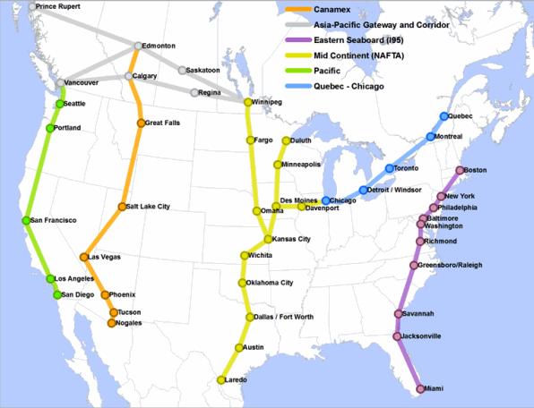
CentrePort Canada
It's coming, and it has serious regional economic implications even to smaller communities like Pembina/Emerson/St. Vincent...CentrePort Canada will be an inland port, a gateway "... centrally and strategically located at the heart of North America to connect businesses to world markets." It's part of an ambitious, overall strategy linking the northern Hemisphere for economic gain via the Arctic Bridge. In turn, it connects to the United States/Mexico corridor via Highway 75 through Emerson/Pembina, "...one of the busiest border crossings in Western Canada, which handles approximately three-quarters of Manitoba's trucking exports to the two other NAFTA countries."

Wednesday, January 21, 2009
Rural Life: Dying or Changing?
We all have seen the decline and depopulation of our hometowns in rural areas, but then you see an inspirational story like this and are reminded it doesn't have to be that way...
Awhile back, Minnesota Public Radio did a series on small town life in Minnesota. It found that "...A number of communities are struggling to manage growth while saving their history. Some say small towns are losing their character. Others say small town life is still good." I daresay most of you from my hometown area reading this - or those of you from other rural areas - will probably agree life is good where you live. I truly don't think those living in rural areas feel stuck there, or disadvantaged, but quite the contrary. It is the spirit of the people that will keep small towns alive.
Wednesday, August 06, 2008
Building I-29
During the 1950's, when the Interstate was being built (I-29), the road workers and their families needed places to park their trailers. Mom and Dad rented some of their land for this. My parents became friends with many of them. These photos show two of the trailers they lived in by our house, one with my sister Sharon standing in front of it.
I've included at the end of this post a brief and fascinating history behind the interstate system in general, and why it was built. It wasn't only for transportation of civilians, but as an important part of our national defense. Our section near the border was one of the first built for that very reason, being seen as a strategic location...

From North Dakota Highways:
North Dakota native Ryan Fischer shared the following information...
Popularly known as the National Interstate and Defense Highways Act of 1956, the Federal-Aid Highway Act of 1956 established an interstate highway system in the United States. The movement behind the construction of a transcontinental superhighway started in the 1930s when President Franklin D. Roosevelt expressed interest in the construction of a network of toll superhighways that would provide more jobs for people in need of work during the Great Depression. The resulting legislation was the Federal-Aid Highway Act of 1938, which directed the chief of the Bureau of Public Roads (BPR) to study the feasibility of a six-route toll network. But with America on the verge of joining the war in Europe, the time for a massive highway program had not arrived. At the end of the war, the Federal-Aid Highway Act of 1944 funded highway improvements and established major new ground by authorizing and designating, in Section 7, the construction of 40,000 miles of a "National System of Interstate Highways."
When President Dwight D. Eisenhower took office in January 1953, however, the states had only completed 6,500 miles of the system improvements. Eisenhower had first realized the value of good highways in 1919, when he participated in the U.S. Army's first transcontinental motor convoy from Washington, DC, to San Francisco. Again, during World War II, Eisenhower saw the German advantage that resulted from their autobahn highway network, and he also noted the enhanced mobility of the Allies, on those same highways, when they fought their way into Germany. These experiences significantly shaped Eisenhower's views on highways and their role in national defense. During his State of the Union Address on January 7, 1954, Eisenhower made it clear that he was ready to turn his attention to the nation's highway problems. He considered it important to "protect the vital interest of every citizen in a safe and adequate highway system."
Between 1954 and 1956, there were several failed attempts to pass a national highway bill through the Congress. The main controversy over the highway construction was the apportionment of the funding between the Federal Government and the states. Undaunted, the President renewed his call for a "modern, interstate highway system” in his 1956 State of the Union Address. Within a few months, after considerable debate and amendment in the Congress, The Federal-Aid Highway Act of 1956 emerged from the House-Senate conference committee. In the act, the interstate system was expanded to 41,000 miles, and to construct the network, $25 billion was authorized for fiscal years 1957 through 1969. During his recovery from a minor illness, Eisenhower signed the bill into law at Walter Reed Army Medical Center on the 29th of June. Because of the 1956 law, and the subsequent Highway Act of 1958, the pattern of community development in America was fundamentally altered and was henceforth based on the automobile.
I've included at the end of this post a brief and fascinating history behind the interstate system in general, and why it was built. It wasn't only for transportation of civilians, but as an important part of our national defense. Our section near the border was one of the first built for that very reason, being seen as a strategic location...

From North Dakota Highways:
North Dakota native Ryan Fischer shared the following information...
I-29 has a very peculiar history. Its first stretch was completed in the late 50s from Drayton to the Canadian border, making it among the earliest sections of Interstate highway built from scratch. Why it was built so early in such a sparsely populated part of the country baffles everyone I know from back home. Ahhh, the U.S. government...[NOTE from Trish - see bottom of this post for a VERY good reason why - defense of the country in strategic locations]Some history...
I-29 was built along the US-81 alignment across much of extreme eastern North Dakota. The segment from the Canadian border to Drayton was opened as a 2-lane, undivided alignment in the late 1950's, as an upgraded segment of ND-44. By 1975, I-29 was compete as far south as Walcott. The entire highway in the state was completed by 1977.National Interstate and Defense Highways Act (1956)
In early Interstate highway plans from 1957, only the Fargo to Pembina segment was planned, and this was to be designated as I-31; I-29 was reserved for the current alignment from Sioux Falls, SD, to Kansas City, MO. On October 18, 1957, the Bureau of Public Roads recommended an interstate from Fargo to Sioux Falls. North Dakota officials requested in February 1958 that the planned I-31 designation be changed to I-29, and federal officials approved.
If you look at 70s era Rand McNally road maps, you will see that the section from N.D. 5 to the Canadian border is marked "Two Lanes." While the overpasses were built and right-of-way was established for the divided, four-lane highway, this section of I-29 functioned as a two lane freeway until the late-70s.
Popularly known as the National Interstate and Defense Highways Act of 1956, the Federal-Aid Highway Act of 1956 established an interstate highway system in the United States. The movement behind the construction of a transcontinental superhighway started in the 1930s when President Franklin D. Roosevelt expressed interest in the construction of a network of toll superhighways that would provide more jobs for people in need of work during the Great Depression. The resulting legislation was the Federal-Aid Highway Act of 1938, which directed the chief of the Bureau of Public Roads (BPR) to study the feasibility of a six-route toll network. But with America on the verge of joining the war in Europe, the time for a massive highway program had not arrived. At the end of the war, the Federal-Aid Highway Act of 1944 funded highway improvements and established major new ground by authorizing and designating, in Section 7, the construction of 40,000 miles of a "National System of Interstate Highways."
When President Dwight D. Eisenhower took office in January 1953, however, the states had only completed 6,500 miles of the system improvements. Eisenhower had first realized the value of good highways in 1919, when he participated in the U.S. Army's first transcontinental motor convoy from Washington, DC, to San Francisco. Again, during World War II, Eisenhower saw the German advantage that resulted from their autobahn highway network, and he also noted the enhanced mobility of the Allies, on those same highways, when they fought their way into Germany. These experiences significantly shaped Eisenhower's views on highways and their role in national defense. During his State of the Union Address on January 7, 1954, Eisenhower made it clear that he was ready to turn his attention to the nation's highway problems. He considered it important to "protect the vital interest of every citizen in a safe and adequate highway system."
Between 1954 and 1956, there were several failed attempts to pass a national highway bill through the Congress. The main controversy over the highway construction was the apportionment of the funding between the Federal Government and the states. Undaunted, the President renewed his call for a "modern, interstate highway system” in his 1956 State of the Union Address. Within a few months, after considerable debate and amendment in the Congress, The Federal-Aid Highway Act of 1956 emerged from the House-Senate conference committee. In the act, the interstate system was expanded to 41,000 miles, and to construct the network, $25 billion was authorized for fiscal years 1957 through 1969. During his recovery from a minor illness, Eisenhower signed the bill into law at Walter Reed Army Medical Center on the 29th of June. Because of the 1956 law, and the subsequent Highway Act of 1958, the pattern of community development in America was fundamentally altered and was henceforth based on the automobile.
Monday, May 26, 2008
St. Vincent Gets Street Signs
Only took 150 years give or take, but St. Vincent now has street signs!
The corner in the above photo has special significance to me; it is at the main street of the town, at the corner where my grandmother's house is...up the road a few blocks is where their old house is, and where I grew up.
By the way, according to maps drawn up at the time St. Vincent became an official city, the street names now used on these new signs were the original street names...
Subscribe to:
Posts (Atom)