Showing posts with label floods. Show all posts

Wednesday, September 09, 2015

Obituary: William H. Moorhead


Apprentice Carpenter. Land Agent. Indian Trader. Trading Post Clerk. Buffalo Hunter. Undertaker. Farmer. Tavern Keeper.

Below is the obituary of an extraordinary man, one of our area's true pioneers.  I have left all the spelling as it appeared in the original article of the newspaper just as I found them, to give you a flavor of how common it was.  Some of the errors may have been due to misspellings or incorrect typesetting, but just as often there was no consistent agreed-upon spelling conventions for some words - Sometimes they just had to make their best guess!

PIONEER DEAD
William H. Moorhead Died Yesterday Morning at His Home In Pembina.
HAD BEEN ILL SIX MONTHS
And Underwent a Surgical Operation Here About Two Weeks Ago
Mr. Moorhead was One of the leading Characters in the Early Settlement of the Valley and was a Typical Frontiersman —"High Water Bill" was the Name by which He was Best Known— The Funeral Occurs Tomorrow.
Pembina, N.D., July 3.—(Herald Special)— William H. Moorhead, better known during later years as "High Water Bill," died at his home in this city this morning, after an illness extending more or less over the past six months. This sobriquet he gained by his numerous prophecies as to just how high the water in the Red river would rise each year, and, be it said, his predictions were usually not far astray. As an incident in this line - it is said that this spring, before the snow melted, as he was lying in his bed on the lower floor of his house talking "high water" to a visitor, he reached down about half way on one of his bed posts and said. "You'll see the water up to this spot when the snow melts," and his prediction was verified. He refused to be carried upstairs until the water came in on the floor.
Floods had been known to fill the Red River Valley with snowmelt runoff. The earliest pioneers remembered the flood of 1861. That spring, the Red River Valley was under so much water that it was called the “largest body of fresh water in the world” – for a few weeks, anyway.   -   North Dakota Studies, FLOODS
Wm. H. Moorhead was born in Freeport, Pa., Sept. 26, 1832. He left Pittsburgh where he received a common school education, April 1, 1852, and arrived in St. Paul, a month later, where he worked at his trade—that of a carpenter—for two years.

The summer of '54 and the following winter he spent at Sauk Rapids trading with the Winnebagos, when they were removed to Blue Earth county. He then returned to St. Paul and organized a company to lay out paper townsites in northern Minnesota and Red River Valley.

In August, '57, he came to Pembina in company with Joe Rolette to build a store building for a trading post for St. Paul parties. He completed the building and remained as clerk to February, '58, when he made a trip to St. Paul with a dog train, not seeing a single house between the two points. He returned to Pembina soon after, having some fearful blizzard experiences on the way.

On June 8th of the same year he left Pembina on a buffalo hunt and returned in August with 15 Red river carts laden with furs, hides and Pemican.

After the high water of '61 which was the flood, according to his tell, he moved out to Walhalla. Here he lived on very friendly terms with the Indians until hostilities broke out which ended in the Minnesota massacre and because he refused to sell ammunition to the hostiles, he had to leave. He moved near Devils Lake and pursued his trading.

In 1862 he married Lizzie Rivier, who with her five children still survives him. About this time he moved to Pembina, where he has since resided.

Source:  Google Books
Mr. Moorhead has long enjoyed the distinction of being the second oldest white settler in the valley. Hon. Chas. Cavileer, of this city, being the oldest having come in 1841. When the Historical society of North Dakota was created in 1895, Gov. Allin appointed Mr. Moorhead a member of it and he has collected considerable information for it since.

Mr. Moorhead was a typical frontiersman and a general favorite. The history of the Red River Valley would be far from complete without an interesting reference to a man who was known far and wide for his genial good nature, and interesting stories of the pioneer's life in the northwest.

Mr. Moorhead has been a member for years of Pembina lodge No. 2, A. F. and A. M., and the funeral, which will take place Monday afternoon at 4 o'clock, will be under the auspices of that order.

[July 04, 1897, Grand Forks Herald]

Thursday, October 31, 2013

The Border

The little border town of Emerson, Manitoba, was a surreal place to be in April 1997.  Behind the permanent dike that had been doubled in height with the addition of a temporary structure of plywood and sandbags, Emerson was a dry island in the vast sea of the Red River, which had burst its banks.  All the inhabitants, with the exception of a few who had been left behind to fight the flood, had been evacuated.  The electric power still worked, so that at night the island of Emerson was ablaze in a strange white light.  Deer and hares and other smaller animals had gravitated to the town to escape the ice cold waters of the raging river.  They stood, frightened sentinels, in the white light of the ghost town. 
A remarkable crew made up of town employees, a detachment of troops from the Canadian Forces and local Mounties kept the town of Emerson itself dry and secure.  As the river rose to a critical level in late April, with no firm prediction on how high it would get, the struggle to maintain the wall around the town was in deadly earnest.  Coordinated out of the Emerson Town Hall, the beleaguered warriors filled sandbags and directed them to potential weak points on the perimeter.  So close is Emerson to the U.S. border, that a portion of the dike actually crossed into the small neighboring community of Noyes, Minnesota, protecting a U.S. Customs office and several nearby homes on U.S. soil.  As residents noted at the time, what they were calling the "Red Sea" did not make distinctions between one side of the border and the other.
[The writer returns five years later, and talks to survivors in both Emerson and Pembina of their ordeal during the 1997 flood, then goes to the border to travel to Grand Forks to interview survivors there...]
In the large new Canada Customs post at the border- built since the flood of '97 - I meet two tall, muscular customs officers who have recollections of the mayhem...When asked about the purpose of my trip to North Dakota by a U.S. Customs official with grey hair, I tell him I am going to Grand Forks to talk to people on the fifth anniversary of the flood of '97.  Not bothering to ask me for ID, he comments sardonically, "Why not go to Pembina?  They know at least as much about the flood as anyone in Grand Forks." 
I follow his advice and drive into the little town of Pembina, two minutes south of the border.  The town had been British territory before it was handed over the U.S. with the adoption of the forty-ninth parallel as the border across the Prairies in 1818.  On the east side of Pembina, there is a high earthen dike to protect the town from the Red River.  It is the same on the other side of the river in the tiny hamlet of St. Vincent Minnesota.  This April the Red is tame, but the dike is there for protection against future floods. 
On the main street of Pembina, I find an old preacher and his young disciple out trying to win converts.  I ask them if they were in town for the great flood of '97.  In reply, the old man hands me a pocket-sized pamphlet titled, "A Preacher of the Old School."  In our conversation, Mr. W. Seed and I are at cross-purposes.  He is trying to save my soul from a flood of biblical proportions while I am in search of memories of a mere earthly flood.  I manager to get Mr. Seed onto my line of inquiry, and he tells me of the long series of floods that have afflicted this community - in 1897, 1950, 1966, and 1979.  In 1997, he says, the dike held and the town was saved.
From:  The Border: Canada, the US and Dispatches From the 49th Parallel

Sunday, June 23, 2013

What Could Have Been

From the 1893 Plat Atlas - Click to Enlarge
[Map Credit:  Library of Congress]

In the section of Pembina shown above - part of the 1893 Plat Map of Pembina County - you can see how the railroad was set up to come in north/south, but had a spur going southeast towards St. Vincent. In a stereoview of St. Vincent, it shows a spur coming up from the main track into town from the east, that then turn north and goes along the river to the exact point across the Red from the Pembina spur. At that time, the only thing needed was a railway bridge over the river, but that never happened, and that was one reason of many that discouraged more growth in St. Vincent. There was some serious missed opportunities, poorly thought-out politicking, etc. that went into it all. The nail in the coffin came around the infamous 1897 flood, after which J.J. Hill wanted to move the town out to the wye, aka the Junction and higher ground.  But Mayor Deacon said no to the offer, without discussing it with any other city council member, let alone the townspeople.  We can only speculate as to his reasons.

St. Vincent Spur that once went round north to opposite bank
from Pembina's spur, meant to cross river via bridge never
built, every likely thanks to William Deacon's fateful decision


Sunday, February 24, 2013

Past Resident Memories: John Stranger

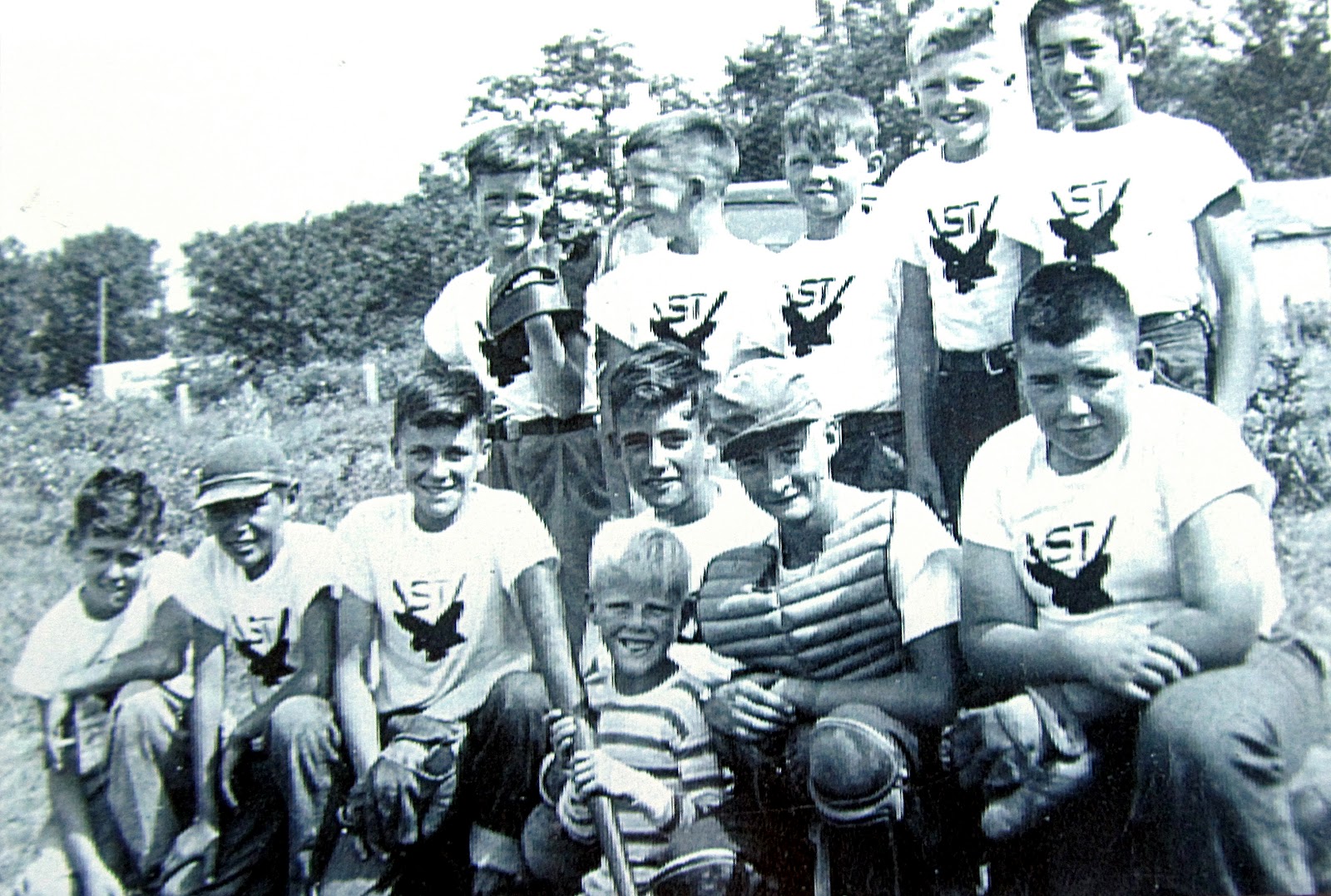
John Stranger - Back row, middle


A MEMOIR OF A LIFE, FOR BETTER OR WORSE
By John A. Stranger

CHAPTER ONE
Beginnings

This all begins in a small town in Minnesota during the 40's when growing up was a struggle without all the things a boy wants and dreams about. Outdoor toilets and dressing behind the oil burner turned up full blast where my brother (4 yrs. Younger) and I learned to dress very fast during the cold Minnesota winters.

My brother was a great kid even though we would have our brotherly confrontations. We had a younger sister too and she learned to hold her own with us boys. Our parents were very strict on almost everything that they thought was for our best interests even though we tried to disagree with our parents at times but trying to obey seemed better than a beating, (most we probably had coming).

Sunday, June 17, 2012

Profile: A.H. Anderson


Who was the man who photographed the 1897 Red River flood in St. Vincent?  The man who took the famous "High Water" series photographs?

His name was Andrew H. Anderson.

He was a farmer who happened to have an eye for photography. He apprenticed in Fergus Falls, Fosston, and Grand Forks before he began a photography business in Hallock in the1890s. 

He eventually sold his interest in his photography business to then partner William Hartvig so he could focus on farming.  But he returned to photography when he bought the studio of G. G. Shaker in Hallock in 1936.  

Born in 1867, he lived a long life in our area, passing away in 1960.  He chronicled many events and families in Kittson County!


Friday, July 15, 2011

Water, Water Everywhere

St. Vincent Post Office, during the 19-- Flood
[Photo Courtesy Perm Diamond]
Short's Cafe was near the river; it survived many floods over the years
[Photo Courtesy Perm Diamond]
Noyes Depot under water...
[Photo Courtesy Perm Diamond]

Monday, January 24, 2011

Highwater Bill "on hand"


William H. Moorhead was a colorful character that was involved in many events of local historical significance.  I have written about him before, as well as shared a story written about our area that featured him in it.  In the course of my research, his name has come up over and over again in accounts of history relating to my hometown area.

The above article was reprinted many years ago, showing photographs featuring "Highwater Bill" in them, during the 1893 flood.  Click on it to see an enlarged version, easier to read...

Monday, January 10, 2011

Collector Photos: Wayne Stewart

I can't prove it, but I'd bet that this photographer is the one who took
this infamous photograph of the 1897 Red River Flood in St. Vincent...
These photos are from the Wayne Stewart collection. This first photo shows another photographer taking a picture. The photographer being shot is setting up to take a picture of two men in a boat during the 1897 flood in St. Vincent. The print is labeled as taken on April 22, 1897; written on the side of the boat are the words, "Ferry Boat for St. Vincent".

Ad sign, as seen on building in above photo

Further in the background, on the upper story of the storefront behind them, is an ad for Climax Plug Tobacco, a popular chew of the time, and purported to be the inspiration for the Minnesota town of the same name.

I've been in touch both indirectly and directly a few times with Wayne in recent months about various subjects, mostly connected with his photograph collection, but also his brother Bob.

In a mailing to me from last year, that included the photos in this post, Wayne had this to say...

Sunday, December 19, 2010

Old St. Vincent in Photos: 1948 Flood

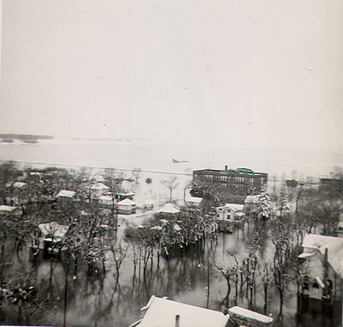
The pictures below were recently shared by a reader of this blog, a descendant of an early settler of the St.Vincent/Pembina area. Most of them were taken during the 1948 flood, with a few taken in other (mostly) unspecified but close years to 1948, including one of the then-new St. Vincent elevator, identified by handwriting on the back as being erected in 1950...

From far right front backwards:  Mont(gomery) Clinton's Minneapolis-Moline 
dealership, Art Clinton's home (Baker's Pool Hall), Post Office (Bill Ahles' 
grainery), (George) Sylvester's Store (Old Dick Lapp/Ahles Store), 
old City Hall, and finally, Short's Cafe (old First & Last Chance Saloon...)

Saturday, June 20, 2009

Interlude: Red Gets Out of Bed Again!

Carrie Snyder / The Forum
Yes, that darn Red River of the North is out of its bed again! I went walking today and was shocked to see the river way out of its bed, up at the foot of the dikes here in Fargo, totally covering the banks and even the walkways and low roads along it. Farmers markets had to be held in alternative locations, pedestrian river bridges were pulled off of the river, fully-blossomed trees were being drowned. This has been one of those strange but definitely-not-unheard-of years where the Red is temperamental, up then down, raging then quiet. All the while, pockets of too much rain cause some valley farmers to stay out of the fields, some fields likely not to be planted at all this year...

Saturday, May 30, 2009

Looking South

Taken from Canadian side of border, looking south, this is the Emerson, MB/Pembina, ND border crossing. [Courtesy James McClelland, Emerson...]

I know - the last thing most of us wanted to see was MORE flood photos! But I really liked this shot.

Tuesday, May 12, 2009

1950 Flood from the Water Tower

1950 Red River of the North FloodWilliam Ash shared, "I found these photos a few weeks ago and have just scanned them into my computer. The first five photos of the 1950 flood was taken by my mother Audrey Joyner who was working as a secretary at the US Customs District Headquarters building in downtown Pembina, ND during the 1950 spring flood. She climbed the Pembina water tower to take the photos.

"All the flood photos from 1950 that I sent you today were in a large brown envelope in my mother's former house on the farm in a dresser drawer in the attic. They belonged to my grandparents the Sheldon Joyner's which my mom collected after cleaning out her mother's house after her passing."

Wednesday, April 29, 2009

"...and now, for something completely different!"

From Willie Block’s “25 Things I Hate About the Red River”
1. It floods.

2. It does not obey the 100-year flood rule. Like at all.

3. It’s not all that Red.

4. It has to be different and flow North. Even when you’re not conforming you’re conforming, you ass.

5. It connects us to Grand Forks . . . city rivalry BURN.

6. It does not have a single cool marine animal in it. No giant squids, no whales, no sharks, nothing but stupid cat fish.

7. It is a deceptive jerk who pretends to be pretty and scenic to lure home owners to building near by and then boom, flood. Like a Venus fly trap but not cool.

8. Making me sandbag never gets anyone or anything any points.

9. A little known fact. The more curves a river has the older it is. Obviously this one is a young little shit. Explains the screaming temper tantrums for attention. Punk.

10. Has probably killed, like, 12 dudes, 6 chicks, and probably a couple of kids. Not cool dude, not cool.

11. Is a breeding ground for the-biggest-f***-up-God-ever-made-bug, better known as the mosquito. That’s like providing refuge for a terrorist.

12. The Red River is most likely working with Al Qaeda.

13. Has absolutely no sense of timing. Never takes into consideration the plans of other people outside of its self. Sort of like a rock star except the Red River is not a rock star. It’s more like a large dumb body of water. And it isn’t even that large. Just long and stupid.

14. You cannot drink it (actually, it would probably taste better than the shite that’s coming out of the faucet these days).

15. Provides a habitat for cute animals.

16. Besides the winter storms, it’s the only way we ever get on the national news. What about our fantastic urban sprawl?

17. Is a direct cause of global warming. Actually, that’s a lie, but I’m gonna run with it.

18. Is not as rad as the Mississippi.

19. Cannot be used to determine how long to wait before you open your eyes and go hunting for the hidden. “One Red River, two Red River, three Red River” See? Just doesn’t work.

20. You can’t take it shopping or to the movies. It would probably text throughout a movie anyways. Like I said, “This River is RUDE.”

21. Cannot be seen from space. [Note from Trish - WRONG!]

22. Probably talks about you behind your back. “Will thinks he’s all that and the bees knees, but this one time I saw him walking home and he walked right into a tree branch. Dumb ass.” Well, at least I don’t have a bladder problem, River.

23. It will drown you and feel no remorse. None whatsoever. Probably brags about it to the other rivers at the annual “Rivers That Kill Humans” conference.

24. Unlike the Nile—which produced a bad ass culture of Pharaohs, books of the dead and large pyramid houses—it created a bunch of stubborn dudes and babes that don’t know when the getting out is good. “By my cold dead hands.” The river laughs at this and goes “Yes, well, is there any other way?”

25. It is an inanimate object that you CANNOT PUNCH IN THE FACE.
Not my normal posting, but it's VERY funny (to me at least!) so I'm sharing with all of you...

Saturday, April 25, 2009

The Mighty Red

With the recent flood still firmly in everyone's memory (and for some, it's still a very current situation, in the northern end of the valley...), I thought I would share some interesting articles about the Red River of the North...
1825 had been a very good year at Red River. The community was growing and upgrading itself. Forty-two new homes were built in six months. The severe mouse infestation had been the only discouraging event.

The problems had begun during the winter. There had been a giant snow during December 1825. The Metis and Indians wintering in Pembina were near starvation. [Alexander] Ross visited Pembina in February and saw it first hand. A relief effort by individuals and the HBC sent many dog teams south with food and supplies. But many perished, especially in the harsh winter that year. Those that were found alive had devoured their horses, dogs, raw hides, leather and their shoes. The winter continued to bring much snow and temperatures reaching -45. The ice was five feet seven inches thick.

On May 2, 1826, the water rose 9 feet in 24 hours. On May 4 the river overflowed its banks. On the 5th all the settlers abandoned the colony seeking higher ground. The river would rise for 20 days and in places the settlement had a depth of water estimated at 16 feet. What did they save? First came the cattle then the grain, furniture and utensils. The water reached so high people had to break through the roofs of their houses to salvage what they could. Meanwhile ice flows cut everything in their path.

From The 1826 Flood, by George Siamandas [Winnipeg Time Machine]
A few unique facts about the Red River of the North:
- The Red River Valley is the youngest major land surface in the contiguous United States...it was exposed when glacial Lake Agassiz finished draining about 9,200 years ago, whereas most U.S. rivers are millions of years old.

- A normal river occupies a channel with a floodplain on the sides and valley walls immediately adjacent to the floodplain; the Red occupies a channel in a flat lakebed and the nearest valley walls are miles away, allowing its floodwaters to move "as shallow sheets that meet with other shallow sheets..."

- Unlike most U.S. rivers, the Red flows north - spring thaw starts in the southern valley before the northern valley, causing ice jams, backwater flow, and floods.

- The river slopes like a bowling lane, so gradual it's almost imperceptible to the naked eye. That gives the river a tendency to pool, spilling out as a shallow lake 50-60 miles wide at times.

From Have We Seen a Big Flood? (Fargo Forum, April 12, 2009)

Tuesday, April 21, 2009

Floods Make Good Neighbors

The border communities of Pembina, ND and Emerson, MB depended on each other for information. Two respondents said they often compared forecasts and used the activities of the other community — such as evacuation and return — as a gauge against which to measure their own activities:
I got everything I ever wanted from Emerson. I just had to call and they were...just wonderful....There was always someone there on the phone to answer [questions] and to tell us what they were doing. And it’s good to be able to get a little support or advice.

I called [Pembina regularly] to see what was happening.
When Pembina evacuated, the town offered their sandbags to Emerson. In turn, Emerson helped North Dakota residents load sandbags while their Canadian workers were loading their own bags. These American and Canadian elected officials recalled:
At the time, we left the extra sandbags and it was a way of helping Emerson...They didn’t take that many, and then they helped load up, a few of the rural people who came to get sandbags, they helped them load up and it worked out fine. We sent trucks in from Canada— again, with no customs clearance. We went to Pembina and got three semi-loads of sandbags...As we were loading our trucks, there were some residents from outside Pembina. They were coming in with their pick-up trucks to get sandbags. They didn’t know how to run the pallet fork so our operator would stop taking, putting sandbags in our trailer, and go over there and put one in the back of [their truck] and then go back to load and then turn around and then another farmer would come...There was no country there. They weren’t saying, “Hey, what’s that Canadian doing driving our forklift!” They were just happy for someone to put a pallet of sandbags on the back of their truck and away they went.
Some American citizens who depended on Manitoban hospitality actually assisted another Canadian operation. According to one respondent:
Prior to [Emerson’s] evacuation, we had people from Grand Forks [who had] already lost their homes [who] were heading to Winnipeg. I guess to take the invitation of Mayor Thompson and I guess some of the service groups here to stay [in Winnipeg]. [They were] coming up [Interstate 29] and, seeing the sandbagging initiatives from the duty free shop, pulled in and stopped, took their shirts off, and started sandbagging with us. And they said, “We already lost our homes. We’ve got nothing to do once we get to Winnipeg. We wouldn’t mind, you know, spending six to eight hours here helping you guys on the way.”....So there were Canadians and Americans working side by side.
Canada and the United States assisted each other when such activities served the overall interests of both countries, and because, over time, the social or economic ties within the region have produced a sense of affinity between the province and the states. Three respondents elaborated further:
Minnesota, North Dakota, and Manitoba are probably [more of a]community than we are with let’s say some of our sister provinces. You know, like it or not, that’s the truth. A lot of camaraderie and a lot of common ground.
They’re very good neighbors to us.
A lot of Manitobans and Winnipeggers go to Grand Forks to shop or just to have a get away, and similarly, so do Grand Forks people come to Winnipeg. In some ways there’s more affinity between these two cities than there is, you know, across [the country].
Manitoba, North Dakota, and Minnesota are physically and symbolically connected by the Red River. Valley residents viewed these three sub-national governments not only as adjoining jurisdictions but also as neighbors. Generally speaking, Canadians and Americans were willing to do what they could to help their neighboring country. These instances of cross-border assistance occurred on individual, collective, and organizational levels, and were particularly evident in border communities.

INTERACTION BETWEEN
CANADIAN AND AMERICAN
GOVERNMENTAL AND NON-GOVERNMENTAL
ORGANIZATIONS DURING THE
RED RIVER FLOOD OF 1997


submitted to the
International Joint Commission
Ottawa / Washington

by
Tricia Wachtendorf

Disaster Research Center
University of Delaware
January 2000

Saturday, April 18, 2009

1950 Flood from the Air

St. Vincent during the 1950 flood, courtesy of William Ash...

View is from southeast looking northwest. To my trained eye I can locate and identify Short's Cafe, Friebohle's Garage, the Firehall, the Valley Church (which became an EFC church my family attended eventually), my grandparents' house, the curling rink, the old depot's stockpen and barn...and I notice there is no quonset yet, and the bridge over the river is not the one I grew up with, so I am assuming it was yet to be built sometime later in the decade.

Friday, April 17, 2009

NASA Satellite Image of Red River

A fascinating satellite image of Fargo/Moorhead during the heighth of the recent flood. Be sure and take a look at the high-resolution version of the image...

Thursday, April 16, 2009

Pembina Island

Welcome to Pembina Island!

I received this image of the current flood from Chuck Walker yesterday. I don't know who took it, but it's taken from the west looking east. I-29 is at bottom, then Pembina, the Red River of the North, and St. Vincent. You can see the Junction if you know where to look above St. Vincent, and then you hit the farm land which finally fades into the horizon. Somewhere in that patchwork of farm fields, the United States gives way to Canada. In other words, the photo shows parts of one continent, two countries, and three states/provinces. Whoever took this photo, it's a great shot!

Wednesday, April 15, 2009

Border Store

This is the Rustad store in Noyes that was owned and run by great Uncle Carl Rustad and his wife Aagot. It was a store/post office. Carmen Curtis later ran the store for many years and it was a fixture in Noyes from the 1940s through the 1960s and beyond. 
- Mike Rustad 
Frank and Grace Surface were the two that ran it when I knew it, in the late 1960's and 1970's - by then, the post office had moved across the street where Carmen was still the postmaster, but the store remained in this same building. Many a week, on the way to my piano lessons in Emerson, my Dad would stop there to let me get a treat or a comic book. Behind it was the Noyes Depot where my Dad worked for many years...

Saturday, April 11, 2009

Like Living on the Nile Delta...

Netley Marsh / Lake WinnipegThe flood legacy of the Red River of the North...
FROM its humble origins as the small Bois de Sioux River along the South Dakota-Minnesota border, the Red River of the North grows wider and deeper until it eventually fans out into a delta at Manitoba’s Netley Marsh1 and flows into Lake Winnipeg. From A Gathering of Waters
A fascinating article from the Winnipeg Free Press, I learned more than a thing or two about my old friend, the Red River.

1 - Netley Marsh is one of the largest waterfowl breeding grounds in North America, the permanent home of 18 varieties of duck as well as of geese, herons, pelicans, terns and various kinds of diver. In spring the population is swollen by thousands of migratory birds. [Planetware]